(compound volcano 2329 m / 7,641 ft)
The Ambalatungan group is a cluster of several volcanoes on northern Luzon Island, Philippines, conprising Ambalatungan, Bumabag, Podakan, and Binuluan volcanoes, aligned roughly E-W.
Ambalatungan volcano is dacitic in composition, and has a steep-walled crater, inside whic... [
more info]
(lava dome 376 m / 1,234 ft)
Amorong volcano a small lava dome in NW Luzon Island, 80 km NNE of Pinatubo volcano, and belongs to the Eastern Volcanic Chain or Balungao Group, a chain of subduction volcanoes behind the Manila Trench.
It is the only of a group of several lava domes that still has fumarol... [
more info]
(Pyroclastic cone 358 m / 1175 ft)
[
more info]
(stratovolcano 1026 m / 3,366 ft)
Arayat is a forested stratovolcano above the flat Central Plain of Luzon Island and located NE of Angeles city, Philippines. It belongs to the Eastern Volcanic Chain, which includes Mounts Balungao, Cuyapo, Amorong and Arayat volcanoes.
Mt. Arayat's cone is probably built u... [
more info]
(complex volcano 2158 m / 7,080 ft)
Banahaw volcano is a complex of 3 volcanoes 80 km SE of Manila, Philippines. The Banahaw volcanic complex includes Mt Banahaw (2158 m), San Cristobal (1470 m), and Banhao de Lucban (1870 m) volcanoes.
Mild explosive eruptions might still occur at the Banahaw volcano complex... [
more info]
(compound volcano 2329 m / 7,641 ft)
Binuluan volcano belongs to the Ambalatungan volcanic group and is located in the Kalinga Province, Luzon Island, Philippines.
A possible steam eruption of Binuluan volcano in 1952 killed 12 people by a sulphur rich debris flow. [
more info]
(Stratovolcano 1565 m / 5,134 ft)
Bulusan, one of the most active volcanoes in the Philippines, is Luzon's southernmost volcano. It lies at the SE end of the Bicol volcanic arc occupying the peninsula of the same name that forms the elongated SE tip of Luzon island. [
more info]
(stratovolcano 1133 m / 3,717 ft)
Cagua is an active stratovolcano at the NE tip of northern Luzon Island, Philippines. It has a circular summit crater of 1.5 km diameter, with steep, 60-m-high walls, and is locally known as the "Fire Mountain". The volcano might have erupted in 1907, when strong fumarole activit... [
more info]
(stratovolcano 1196 m / 3,924 ft)
Mount Iriga volcano is a small stratovolcano immediately SW of Lake Buhi in southern Luzon, Philippines.
The volcano is dominantly andesitic in composition, but has several basaltic flank cones. It has a large crater breached to the SE, which formed during a massive flank f... [
more info]
(stratovolcano 1966 m / 6,450 ft)
Isarog volcano is an andesitic stratovolcano of Naga city, in SE Luzon, Philippines. It is part of the Bicol volcanic chain, and could still be active although no historic eruptions are known. The volcano has active fumaroles, steam vents and hot springs. [
more info]
(stratovolcano 1544 m / 5,066 ft)
Mount Labo volcano is located SW of the city of Daet at the northwestern end of the Bicol Volcanic Arc on Luzon Island, Philippines.
It is a forested, andesitic stratovolcano with a basal diameter of 24 km. Labo last erupted about 27,000 years ago, but still shows geotherm... [
more info]
(caldera 743 m / 2,438 ft)
The elliptical, 10 x 20 km wide caldera of Laguna de Bay is located immediately SE of Manila city, Philippines. It is the largest lake on Luzon Island and its surface is only 1 m above sea level.
Jalajala is a fumarole field on the flank of Mount Sembrano on the shore of La... [
more info]
(stratovolcano 1090 m / 3,576 ft)
Makiling volcano is a small perhaps still active stratovolcano in Laguna Province, Luzon Island, Philippines, on the southern shore of Laguna de Bay close to Manila city. Hot springs are located near Makiling at Los Baños town. [
more info]
(stratovolcano 1548 m / 5,079 ft)
Malinao volcano (also known as Buhi or Takit) is a forested stratovolcano north of Mayon volcano and 3 km west of Malinao town, in southern Luzon, Philippines.
The volcano contains a large summit crater breached to the east.
Malinao was active from about 500,000 to ... [
more info]
(stratovolcano 1157 m / 3,796 ft)
Malindig volcano (also known as Marlanga), is an andesitic stratovolcano at the southern tip of Marinduque Island, west of the Bondoc Peninsula on Luzon Island, Philippines.
The summit has sharp peaks. No recent eruptions have occurred at the volcano. Hot springs are activ... [
more info]
(stratovolcano 1388 m / 4,554 ft)
The small, but voluminous Mariveles stratovolcano is located at the southern end of the Bataan Peninsula, on the west side of Manila Bay, Luzon Island, Philippines.
Although there are no known eruptions in historic times, it is a still active stratovolcano of andesitic com... [
more info]
(stratovolcano 1328 m / 4,357 ft)
Masaraga volcano (left in the picture) with its taller and active neighbor, the Mayon stratovolcano seen during approach for Legazpi airport.
Masaraga is a stratovolcano with a pointed top located 10 km NW of Mayon volcano on Luzon Island in the Philippines.
The flanks of the andesitic-to-ryholitic volcano are covered by forested thick lava flows, indicating no recent eruptions, but it is thought that it has erup... [
more info]
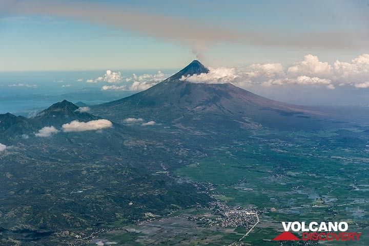
(Stratovolcano 2462 m / 8,077 ft)

The majestic, perfectly symmetrical Mayon stratovolcano seen from the northwest during its eruption in 2018.
Mayon, the most famous of the active volcanoes of the Philippines, is a perfect stratovolcano rising to 2462 m on Luzon Island. It erupts very frequently. [
more info]
(stratovolcano 1253 m / 4,111 ft)
Natib is a massive andesitic stratovolcano located at the northern end of the Bataan Peninsula, Luzon Island, Philippines.
It is truncated by a 6 x 7 km wide caldera. The age of its last activity is uncertain and the volcano might still be active. 5 thermal areas are presen... [
more info]
(stratovolcano 501 m / 1,644 ft)
Mount Panay is small andesitic stratovolcano on the Calumpang Peninsula west of the Batangas Bay, south of Lake Taal, Luzon Island, Philippines.
Panay may be extinct with its last eruptions being more than 10,000 years ago, but it still has strong solfataric activity. [
more info]
(stratovolcano 1865? m / 6,119 ft)
Mount Patoc is an andesitic stratovolcano in the Cordillera Central of north-central Luzon, Philippines. It has strong fumarolic activity. A small river and a village on the west side are named "Mainit", which means hot. [
more info]
(stratovolcano 1486 m / 4,875 feet)
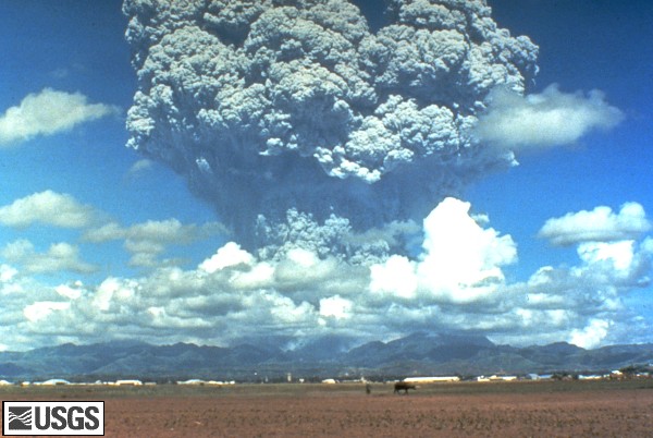
The June 12, 1991 eruption column from Mount Pinatubo taken from the east side of Clark Air Base. U.S. Geological Survey Photograph taken on June 12, 1991, 08:51 hours, by Dave Harlow.
Pinatubo volcano exploded spectacularly on 15 June 1991. The Pinatubo eruption on 15 June 1991 was the second largest volcanic eruption of the 20th century.
Pinatubo is a complex of lava domes located 100 km NW of Manila city, Luzon Island, Philippines.
Prior to the... [
more info]
(compound volcano 1102 m / 3,615 ft)
The volcanic Pocdol Mountains (also known as Bacon-Manito complex) are a group of volcanic cones between Saragon Bay and Albay Gulf in southern Luzon.
Some of the cones are probably only a few thousands of years old. A fumarole field and a geyser are found in the area, sug... [
more info]
(stratovolcano 1090 m / 3,576 ft)
The San Pablo volcanic field, (also known as the Laguna volcanic field) in Rizal Province, Luzon Island, Philippines, lies at the southern end of Laguna de Bay, the largest lake on Luzon Island. [
more info]
An extinct volcano in Luzon, Philippines, bears the same name as famous and very active Sangay volcano in Ecuador. [
more info]
(stratovolcano 2260 m / 7,415 ft)
Santo Tomas volcano on Luzon Island, Philippines, is one of the highest stratovolcanoes of the country. It has many volcanic vents and fissures.
A report about an eruption or "displacement" in the region on January 4, 1641, described as an outburst of water accompanied by ... [
more info]
(caldera 311 m / 1,020 ft)
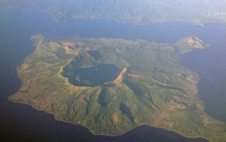
Aerial photo of Taal Volcano on December 22, 2012 (image: Mike Gonzalez, Wikimedia Commons, see text for link)
Taal volcano with its lake-filled 15x20 km wide Talisay (Taal) caldera is a beautiful caldera volcano, but also one of the most active and dangerous volcanoes of the Philippines. Taal has had some of the country's largest and deadliest eruptions: At least 6 eruptions during the r... [
more info]
(stratovolcano 1080+ m / 3,543 ft)
Babuyan Claro (Mt. Pangasun) is the largest and second youngest of 5 volcanoes that built up Babuyan Island, 100 km off the north coast of Luzon, Philippines. Babuyan Claro is an active stratovolcano of ca. 7 cubic km volume and has 2 summit craters of 300 and 400 m in diameter.
... [
more info]
(stratovolcano 712 m / 2,336 ft)
Camiguin de Babuyanes volcano is a small stratovolcano on the SW tip of the 22 km long Camiguin Island in the Babuyan archipelago, 35 km off the north tip of Luzon Island.
Note: A volcanic island called Camiguin is located off the north coast of Mindanao Island. [
more info]
(compound volcano 228 m / 748 ft)
Didicas volcano is a small volcanic island 22 km NE of Camiguin Island, 60 km off the northern coast of Luzon, Philippines.
Until 1952, it was a submarine volcano that had previously formed temporary islands during eruptions. In the eruption of 1952 the submarine volcano fo... [
more info]
(stratovolcano 1009 m / 3,310 ft)
Iraya is an active stratovolcano on Batan Island, 200 km north of Luzon, Philippines. It is the northernmost active volcano in the Philippines. Its last eruption probably happened in 1454 AD, but little details are known about this eruption.
It seems that Iraya volcano's er... [
more info]
(submarine volcano -24 m / -79 ft)
An active submarine volcano is located 5 km west of Ibugos Island, northern Philippines. Eruptions occurred in 1773, 1850, and 1854.
Ibugos is located at the southern end of the Batan Island chain in the Luzon Strait between Luzon and Taiwan. The unnamed volcano rises to w... [
more info]
(compound volcano 1301 m / 4,268 ft)
Biliran volcano comprises the whole 20x35 km Island of Biliran which is formed by a group of lava domes. It is located across the narrow Biliran Strait from the northern tip of Leyte Island.
Biliran volcano is at the northern end of a 170 km long volcanic chain extending S... [
more info]
(stratovolcano 945 m / 3,100 feet)
Mount Cabalían volcano is located on the SE tip of Leyte Island, Philippines. It is is an andesitic stratovolcano with steep radial erosion valleys and ridges that are moderately to thickly vegetated.
It contains a summit crater filled by a lake. The crater rim is irregula... [
more info]
(lava domes 900 m / 2953 ft)
Cancajanag volcano is a complex of lava domes located 6.5 km NNW of Lobi volcano on Leyte Island, Philippines. The age of its most recent eruptions is not known, but it was classified as potentially active by PHIVOLCS. [
more info]
(Stratovolcano 2435 m / 7,989 ft)
Canlaon volcano (also spelled Kanlaon) on Negros Island is one of the most active volcanoes of the Philippines and the most active one of the Central Philippines. It forms the highest peak of Negros Island and is located west of Canlaon about 36 km southeast of Bacolod City and b... [
more info]
(complex volcano 1862 m / 6,109 ft)
Cuernos de Negros (also known as Magaso) is a large stratovolcano complex located in SE Negros Island, Philippines, near the city of Dumaguete. It is unknown when it has erupted after since the last radiocarbon-dated activity about 14,000 years ago. At present, it still has activ... [
more info]
(stratovolcano 860 m / 2,821 ft)
Mahagnao volcano (also known as Kasiboi or Casiboi) is a forested andesitic stratovolcano in central Leyte Island, Philippines.
The volcano contains a steep-walled forested summit crater open to the south. Malagsom and Danao are 2 lakes located on the south flank. Malagsom ... [
more info]
(complex volcano 1885 m / 6,184 ft)
Mandalagan volcano in northern Negros Island, Central Philippines, is an eroded dominantly andesitic-dacitic volcanic complex. It is formed by 7 volcanic edifices and has at least 5 craters of up to 2 km in diameter, some of which are probably calderas. The age of its last erupt... [
more info]
(stratovolcano 1510 m 4,954 ft)
Silay volcano is the northernmost volcano on Negros Island lies 28 km east of Silay City. It is a basaltic-andesite stratovolcano with a partially breached, 3.5-km-wide summit caldera.
It is unknown when the last eruptions occurred at Silay volcano. The Malisbog solfatara ... [
more info]
(pyroclastic cones 811 m / 2,661 ft)
Jolo volcano is a group of young cinder cones and explosion craters on the 60-km-wide Jolo Island located off the Zamboanga Peninsula on SW Mindanao Island in the southern Philippines 190 km NE of Sabah, Malaysia.
It is part of the Sulu arc and contains several young volcan... [
more info]
(Stratovolcano? 1532 m / 5026 ft)
[
more info]
(stratovolcano 2938 m / 9,639 ft)
Apo volcano is the highest mountain in the Philippines, and its name means "Master" or "Grandfather". There are no known historic eruptions, but the volcano is considered still active. [
more info]
(compound volcano 2450 m / 8,038 ft)
Balatukan (also known as Balingoan or Balatocan) is a massive compound stratovolcano on the SW shore of Gingoog Bay, 15 km SW of Gingoog city in north-central Mindanao, opposite Camiguin Island, Philippines.
Lava flows on its flanks are 140,000 years old and it is not known... [
more info]
(stratovolcano 862 m / 2,828 ft)
Balut volcano (also known as Sanguil) is a small island of the Sarangani group south of the Batulaki Peninsula at the south end of Mindanao Island in the Philippines.
The age of the last activity on Balut volcano is unknown, but hot springs and thermal areas are active on ... [
more info]
(stratovolcano 1552 m / 5,092 ft)
Hibok-Hibok volcano (also known as Catarman volcano) is the youngest and the only historically active volcano on Camiguin Island, which is located 9 km off the north coast of Mindanao Island, Philippines.
Camiguin island itself is a 292 sq km oblate, 20 km long island compo... [
more info]
(Stratovolcano(es) 700 m / 2297 ft)
[
more info]
(stratovolcano 2824 m / 9,265 ft)
Kalatungan volcano (also known as Catatungan), is the second highest volcano in the Philippines and located 47 km east of Lake Lana on Mindanao Island.
The dominantly basaltic volcano forms a broad E-W trending ridge. The age of its last activity is unknown. [
more info]
(stratovolcano 2338 m / 7,671 ft)
Latukan is a poorly known volcano SE of Lake Lanao, in NW Mindanao Island (Philippines). The probably still active volcano lies in the center of a chain of young E-W trending stratovolcanoes, between the active Ragang and Makaturing volcanoes. The age of Latukan's last activity i... [
more info]
(stratovolcano 1080 m / 3,543 ft)
Leonard Range (also known as Leonard Kniazeff) volcano is an andesitic-dacitic volcanic complex with a 4x5 km caldera. It is located east of Davao Gulf in SE Mindanao, east of the major N-S-trending Philippine Fault and belongs to the East Mindanao Arc.
The last activity o... [
more info]
(stratovolcano 1940 m / 6,365 ft)
Makaturing is a stratovolcano at the shore of Illana Bay located about 40 km South of Marawi city, in central Mindanao, Philippines.
It is part of the Central Mindanao Arc. Many eruptions reported from Makaturing were actually from neighboring Ragang volcano, and there are... [
more info]
(stratovolcano 2404 m / 7,887 ft)
Malindang volcano is a stratovolcano on the western margin of Iligan Bay in north-central Mindanao Island, 20 km NE of Tambulig, Philippines. It is part of the Malindang National Park. [
more info]
(stratovolcano 2286 m / 7,500 ft)
Matutum is a symmetrical stratovolcano located in southern Mindanao, NW of Sarangani Bay and 30 km NNW of General Santos City.
The mountain, a popular hiking destination, has a well-preserved summit cone and a 320 m wide and a vegetated 120 m deep summit crater. The crater... [
more info]
(lava dome 646 m / 2,119 ft)
Musuan volcano (also known as Calayo volcano) is an isolated lava dome near the Pulangi River at the western base of Mt Tangkulan (1678 m) in Bukidnon Province in central Mindanao, Philippines. [
more info]
(stratovolcano 524 m / 1,719 ft)
Paco volcano (also known as Manlayao or Paco-Manlayao) is located at the NE tip of Mindanao Island, Philippines.
It is an basaltic-dacitic stratovolcano complex truncated by 2 nested calderas, 2.5 and 5 km in diameter. The volcano is located east of the N-S-trending Philipp... [
more info]
(stratovolcano 1824 m / 5,984 ft)
Parker volcano (also known as Falen locally) is a low, but steep-sided vegetated stratovolcano located 30 km west of General Santos City, near the southern tip of Mindanao Island, Philippines.
The andesitic-dacitic volcano contains a 2.9 km diameter summit caldera with a l... [
more info]
(stratovolcano 2815 m / 9,235 ft)
Ragang is an active stratovolcano 40 km SE of Marawi city, Mindanao Island, Philippines. It is Mindanao's most active volcanoes and belongs to the Central Mindanao Arc. Most of its historic eruptions were small explosive eruptions from the summit crater.
The volcano has a d... [
more info]