| RSS | EN | DE | EL | ES | FR | IT | RU

Santiaguito Volcano

Updated: Mar 31, 2025 15:20 GMT -
Stratovolcano
Guatemala, 14.76°N / -91.55°W
Summit height: 3772 m (12,375 ft)
Current status: erupting (4 out of 5)
Last update: 31 Mar 2025 (Volcanic Ash Advisory)
The lava dome complex of Santiaguito volcano seen from Santa Maria's summit

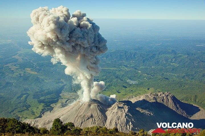
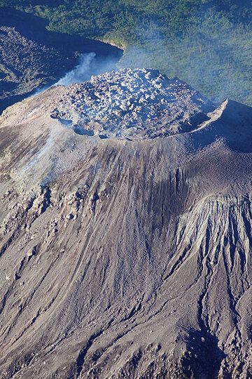
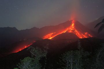
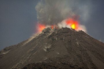
Santiaguito is the name of the dome complex that grew inside the collapse scar left by the catastrophic eruption and partial collapse of Santa María stratovolcano in 1902. Its currently active dome is called Caliente (the "hot one").
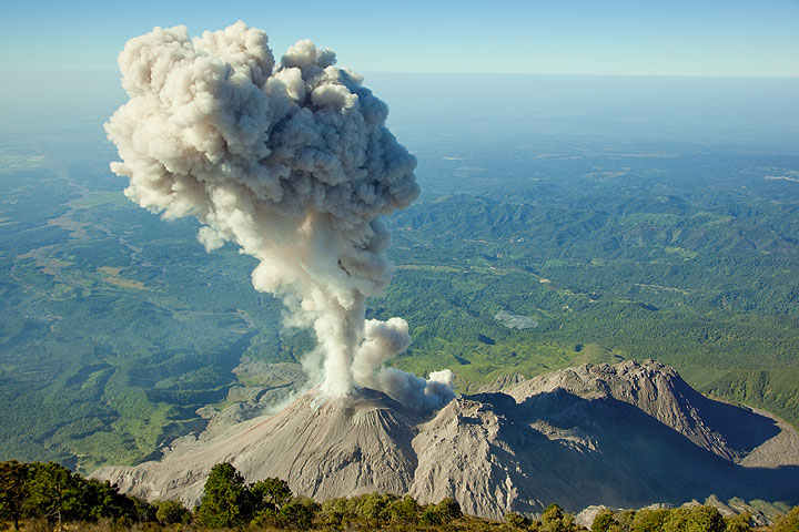
Symmetrical, forest-covered Santa María volcano is one of the most prominent of a chain of large volcanoes that rises dramatically above the Pacific coastal plain of Guatemala. Santa Maria erupted catastrophically in 1902 destroying its former summit.
Santa Maria is a popular excursion destination and the summit offers spectacular views onto erupting Santiaguito.

[smaller] [larger]
Typical eruption style: Dominantly explosive, formation of lava domes
Santiaguito volcano eruptions: 1902 (catastrophic Plinian eruption of Santa Maria), 1903, 1922-ongoing (Santiaguito dome complex)

Latest nearby earthquakes

Date and TimeMag / DepthDistance / Location

Background

The 3772-m-high stratovolcano has a sharp-topped, conical profile that is cut on the SW flank by a large, 1.5-km-wide crater. The oval-shaped crater extends from just below the summit of Volcán Santa María to the lower flank and was formed during a catastrophic eruption in 1902. The renowned plinian eruption of 1902 that devastated much of SW Guatemala followed a long repose period after construction of the large basaltic-andesite stratovolcano. The massive dacitic Santiaguito lava-dome complex has been growing at the base of the 1902 crater since 1922. Compound dome growth at Santiaguito has occurred episodically from four westward-younging vents, the most recent of which is Caliente. Dome growth has been accompanied by almost continuous minor explosions, with periodic lava extrusion, larger explosions, pyroclastic flows, and lahars.
Source: GVP

Santiaguito Volcano Photos

Significant volcanic eruptions: Santiaguito volcano

In the past 10,000 years, Santiaguito has had at least 3 confirmed eruptions, all documented by historical records or observations.
The table below lists all known eruptions (date in bold face) of Santiaguito volcano in historic times and during the past 10,000 years. Updates on the most recent volcanic activity of Santiaguito can be found on the news page of Santiaguito volcano.
DateNoteVEIDeathsDamage
1922 Jun 22 - ongoingSW flank (Santiaguito)
Historical obs./docs.
3
1990 Jul 19
(eruption 1922 Jun 22 - ongoing)
Historical obs./docs.
34
Info
1978 Sep 2
(eruption 1922 Jun 22 - ongoing)
Historical obs./docs.
31
Info
1929 Nov 2
(eruption 1922 Jun 22 - ongoing)
Historical obs./docs.
3200
Info
1903 - 1913SW flank (east end of 1902 crater)
Historical obs./docs.
2
1902 Oct 24 - Nov 12SW flank
Historical obs./docs.
6?
1902 Oct 25
(eruption 1902 Oct 24 - Nov 12)
Historical obs./docs.
610,000
moderate
Info
Remark:
Our list of volcanic eruptions closely follows the database of eruptions of the Smithsonian's Global Volcanism Project (GVP), the internationally most recognized data source for volcanic eruptions, but also includes significant eruptive episodes or related volcano events. "Volcanic eruptions" are usually to be understood as sequences of individual eruptive episodes that can follow each other, or even overlap (if several vents are involved), and can last many years, decades or even longer. For example, the current activity of Stromboli volcano is understood as a single eruption that has been ongoing since 1934.
Sources: NOAA National Centers for Environmental Information (NCEI), Global Significant Volcanic Eruptions Database. doi:10.7289/V5TD9V7K | Global Volcanism Project / Smithsonian Institution

Santiaguito Volcano FAQ

+When was the last eruption of Santiaguito volcano?

+How often does Santiaguito volcano erupt?

+How active is Santiaguito volcano at present?

+When was the largest eruption of Santiaguito volcano?

Latest satellite images

Santiaguito satellite image sat1Santiaguito satellite image sat2
Santiaguito Volcano Tours
11-day volcano tour to Pacaya and Fuego, Guatemala
8-12 days - Moderate to Challenging
Price $ 3590
5-15 Mar 2025
25 Nov - 5 Dec 2025

Santiaguito Volcano Maps

Below is a selection of maps showing the location and surroundings of the volcano at various resolutions based on aerial-imagery / terrain maps. Feel free to use them for non-commercial purposes on your blog or website as long as you credit them with a link back to this page (click to copy it).
Satellite/aerial-type map of Santiaguito volcano (world scale)
Terrain-type map of Santiaguito volcano (world scale)
Satellite/aerial-type map of Santiaguito volcano (region scale large)
Terrain-type map of Santiaguito volcano (region scale large)
Satellite/aerial-type map of Santiaguito volcano (region scale medium)
Terrain-type map of Santiaguito volcano (region scale medium)
Satellite/aerial-type map of Santiaguito volcano (region scale small)
Terrain-type map of Santiaguito volcano (region scale small)
Satellite/aerial-type map of Santiaguito volcano (local scale large)
Terrain-type map of Santiaguito volcano (local scale large)
Satellite/aerial-type map of Santiaguito volcano (local scale medium)
Terrain-type map of Santiaguito volcano (local scale medium)
Satellite/aerial-type map of Santiaguito volcano (local scale small)
Terrain-type map of Santiaguito volcano (local scale small)
Satellite/aerial-type map of Santiaguito volcano (scale of 10s of km)
Terrain-type map of Santiaguito volcano (scale of 10s of km)
Satellite/aerial-type map of Santiaguito volcano (scale of 20-40 km)
Terrain-type map of Santiaguito volcano (scale of 20-40 km)
Satellite/aerial-type map of Santiaguito volcano (scale of approx. 10-20 km)
Terrain-type map of Santiaguito volcano (scale of approx. 10-20 km)
Satellite/aerial-type map of Santiaguito volcano (scale of 5-10 km)
Satellite/aerial-type map of Santiaguito volcano (scale of few kilometers)
Volcanoes & Earthquakes - new app for Android
Guaranteed tours
6-19 Apr 2025: Desert, salt and volcanoes - Danakil desert (Ethiopia)
12-19 Apr 2025: Europe's Volcanic Outpost - Canary Islands
9-25 Jun 2025: Volcanoes and Spices - Sulawesi/Halmahera (Indonesia)
27 Jun - 6 Jul 2025: Iceland Volcano Special - Iceland
7-23 Jul 2025: Volcanoes and Spices - Sulawesi/Halmahera (Indonesia)
1-17 Aug 2025: Volcanoes and Spices - Sulawesi/Halmahera (Indonesia)
13-26 Sep 2025: Green Volcanoes - Azores (Portugal)
1-14 Oct 2025: Desert, salt and volcanoes - Danakil desert (Ethiopia)
4-12 Oct 2025: From Stromboli to Etna - Sicily and Eolian Islands (Italy)
= spaces available   = guaranteed   = few spaces left   = booked out
Santa Maria volcano satellite image (c) Google Earth View

On this page:

Why is there advertising on this site?
Sources: VolcanoDiscovery / VolcanoAdventures and other sources as noted.
Use of material: Most text and images on our websites are owned by us. Re-use is generally not permitted without authorization. Contact us for licensing rights.
Volcanoes & Earthquakes
VolcanoDiscovery Home
Volcanoes | Earthquakes | Photos | Volcano News | App
Adventure & Study Travel
Tours to Volcanoes and Volcanic Areas: walking tours, photo tours, study tours
Tours & Dates | FAQ | About us
Get our newsletter!
Company info
Contact | Legal info | Terms & conditions
Follow us
Follow us on facebook Follow us on Instagram Follow us on Bluesky Follow us on Twitter Visit our Youtube channel
EN | DE | EL | ES | FR | IT | RU
VolcanoDiscovery GmbH, Germany, Reg. nr.: HRB 103744, EU Tax Id: DE 297 465 123 owned and created by
Dr. Tom Pfeiffer, volcanologist, volcano photographer, tour organizer member of
IAVCEI
IAVCEI
Vulkanologische Gesellschaft
Volcanological Society
Ecotourism Greece
Ecotourism Greece
RUV insurance
Insured by R+V
VolcanoDiscovery © 2004- All Rights Reserved | Privacy - Cookie Settings