Peru's volcanoes belong to the subduction zone of the eastern Pacific's Nazca Plate beneath South America all along the west coast of Peru. However, only in southern Peru there are active volcanoes. The rest of the country's cordillera belongs to a volcanically inactive gap, where the subduction is at such a shallow angle that magma is not generated by the process.
| Date | Volcano | VEI | Region | Deaths | Damage | |
|---|---|---|---|---|---|---|
| Sabancaya Sabancaya crater | 3 | Peru | ||||
| Ubinas | ? | Peru | ||||
| Ubinas | 3 | Peru | ||||
| Ubinas | 2 | Peru | ||||
| Ubinas Summit crater | 2 | Peru | ||||
| Ubinas Summit crater | 2 | Peru | ||||
| Sabancaya Summit crater | 1 | Peru | ||||
| 2013 Sep 1 (eruption | Ubinas | 0 | Peru | light | Info | |
| Ubinas | 2 | Peru | ||||
| Sabancaya | 2? | Peru | ||||
| Sabancaya | 2 | Peru | ||||
| Sabancaya | 3 | Peru | ||||
| 1990 May 29 (eruptive episode | Coropuna | 3 | Peru | light | Info | |
| Sabancaya | 1 | Peru | ||||
| Sabancaya | 1 | Peru | ||||
| El Misti | 1? | Peru | ||||
| Ubinas | 2? | Peru | ||||
| Ubinas | 2 | Peru | ||||
| Ubinas | 2 | Peru | ||||
| Ubinas | 2 | Peru | ||||
| Ubinas | 2 | Peru | ||||
| Ubinas | 2 | Peru | ||||
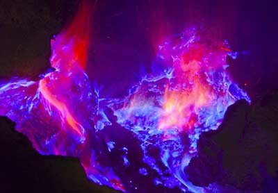
The last volcanic eruption in Peru was from Ubinas volcano in 2024.
The first historically documented eruption occurred around 1454 AD from El Misti volcano.
Since 1454 AD, Peru has seen at least 39 historically documented eruptions. This means that a volcano erupts on average every 14.6 years.
Peru is volcanically relatively active: Since 1900, at least 3 volcanoes in Peru have been active.Since 1900, Peru has had 20 volcanic eruptions from 3 individual volcanoes. Volcanic eruptions have been recorded erupted during 37 years out of 126 as of now. This means, at least one volcano in Peru has been in eruption in one in 3.4 years on average. The last volcano to erupt in Peru was Ubinas volcano, which erupted in 2024, 10 months ago.
The largest eruption in Peru in historic times was from Huaynaputina volcano. It occurred in 1600 AD. It ranks as a plinian eruption with a magnitude 6 on the VEI (Volcanic Explosivity Index) scale. Eruption of this size are often catastrophic on a regional scale.
| Date and Time | Mag / Depth | Nearest Volcano / Location | |||
|---|---|---|---|---|---|
| Apr 15, 12:54 am (GMT -5) | 4.0 35 km | 147 km (91 mi) SW of | Near Coast of Southern Peru I FELT IT | Info | |
| Sunday, April 13, 2025 GMT (1 quake) | |||||
| Apr 12, 10:47 pm (GMT -5) | 4.0 67 km | 467 km (290 mi) NW of | South Pacific Ocean, 80 km south of Lima, Peru I FELT IT - 1 report | Info | |
| Saturday, April 12, 2025 GMT (1 quake) | |||||
| Apr 12, 01:28 am (Lima) | 4.1 17 km | 684 km (425 mi) N of | Central Peru I FELT IT | Info | |
| Thursday, April 10, 2025 GMT (2 quakes) | |||||
| Apr 10, 12:13 pm (Lima) | 4.2 85 km | 239 km (149 mi) NW of | Central Peru I FELT IT | Info | |
| Apr 10, 01:24 am (Lima) | 4.3 10 km | 535 km (332 mi) SE of | 29 km N of Navarro, Peru I FELT IT | Info | |
| Wednesday, April 9, 2025 GMT (1 quake) | |||||
| Apr 8, 10:07 pm (Lima) | 4.1 129 km | 579 km (360 mi) S of | Northern Peru I FELT IT - 1 report | Info | |
| Date | Mag | Region | Deaths | Damage | |
|---|---|---|---|---|---|
| 2007 Aug 15 | 8.0 | Ica, Pisco, Lima | 514 | very heavy | Info |
| 2001 Jun 23 | 8.4 | Arequipa, Moquegua, Tacna, Ayacucho | 103 | very heavy | Info |
| 1991 Jul 23 | 4.7 | Maca, Chivay, Yanque | 92 | moderate | Info |
| 1991 Apr 5 | 6.7 | Rioja, Moyobamba, Nueva Cajamarca | 53 | heavy | Info |
| 1990 May 30 | 6.5 | Moyabamba-riojo | 200 | light | Info |
| 1974 Oct 3 | 8.1 | Lima, Callao | 78 | heavy | Info |
| 1970 Dec 10 | 7.6 | N; Ecuador S | 82 | moderate | Info |
| 1970 May 31 | 7.9 | Northern, Pisco, Chiclayo | 66,794 | very heavy | Info |
| 1969 Oct 1 | 6.2 | Huaytapallana, Lampa, Chilifruta | 150 | moderate | Info |
| 1966 Oct 17 | 8.1 | Lima, Huacho, Huaura, Chancay, Supe, San Nicolas | 110 | heavy | Info |
| 1960 Nov 20 | 6.7 | Peru | 66 | unknown | Info |
| 1960 Jan 15 | 7.0 | Lima, Nazca, Ica, Huancavelic, Palpa, Huaitara | 63 | light | Info |
| 1960 Jan 13 | 7.8 | Arequipa, Chuquibamba, Caraveli, Cotahuasi | 63 | heavy | Info |
| 1950 May 21 | 6.0 | Cusco | 83 | heavy | Info |
| 1947 Nov 1 | 7.3 | Satipo, Andamarca, Acobamba, La Merced, Victoc | 233 | heavy | Info |
| 1946 Nov 10 | 7.3 | Jocaibamba, Cerro Angaschaj, Cerro Sillapata | 800 | heavy | Info |
| 1943 Jan 31 | 5.0 | Yanacoa, Pampamarca | 75 | light | Info |
| 1940 May 24 | 8.2 | Peru | 179 | heavy | Info |
| 1913 Nov 4 | 6.3 | Amyaraes, Abancay, Casaya, Soraya | 150 | heavy | Info |
| 1913 Aug 6 | 7.9 | Caraveli, Chuquibamba, Ocona, Atico | 50-100 (*) | heavy | Info |
| 1912 Jul 24 | 7.0 | Huancabamba, Cajamarca; Ecuador Guayaquil | 100-1,000 (*) | heavy | Info |
The deadliest earthquake in Peru since 1900 was the magnitude 7.9 earthquake in ![]() Peru on May, 31, 1970. It resulted in 66,794 fatalities and 50,000 injured people. A tsunami was generated by the quake as well and contributed to its desctuctive effects. This was the most disastrous quake in Peru ever recorded.
Peru on May, 31, 1970. It resulted in 66,794 fatalities and 50,000 injured people. A tsunami was generated by the quake as well and contributed to its desctuctive effects. This was the most disastrous quake in Peru ever recorded.
Since 1900, at least 75 earthquakes claimed an estimated total of 71,000 fatalities in Peru.
There were 99 damaging or deadly quakes during this period that caused economic losses of approx. $1.8 billion US Dollars combined.