| Date | Volcano | VEI | Region | Deaths | Damage | |
|---|---|---|---|---|---|---|
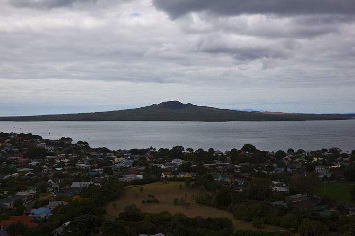
| White Island | ? | Bay of Plenty, New Zealand | ||||
| White Island 1978/90 Crater Complex | 2 | Bay of Plenty, New Zealand | ||||
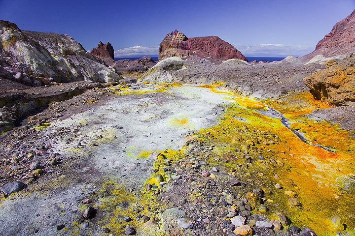
| White Island | 2 | Bay of Plenty, New Zealand | 22 | Info | ||
| White Island 2012 lava dome | 1 | Bay of Plenty, New Zealand | ||||
| White Island 1978/90 Crater Complex | 1 | Bay of Plenty, New Zealand | ||||
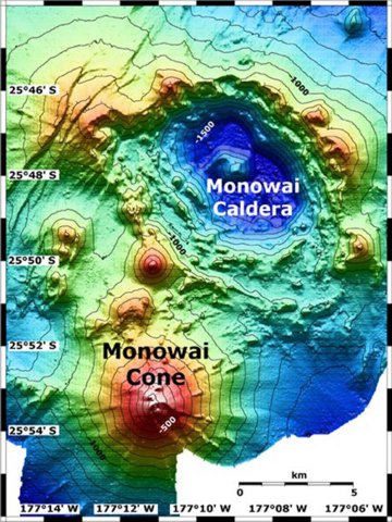
| Monowai Submarine | 0 | Kermandec Islands, New Zealand | ||||
| Monowai Summit | 1 | Kermandec Islands, New Zealand | ||||
| White Island 1978/90 Crater Complex | 2 | Bay of Plenty, New Zealand | ||||
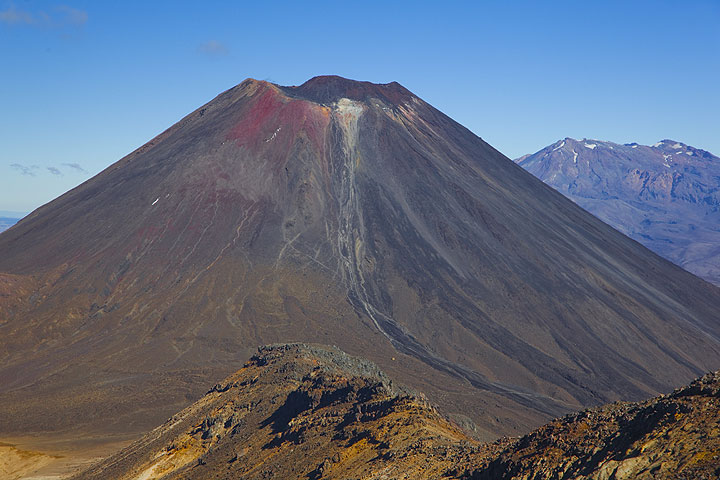
| Tongariro Upper Te Maari Craters | 2 | North Island, New Zealand | ||||
| Monowai Submarine | 0 | Kermandec Islands, New Zealand | ||||
| Tongariro Upper Te Maari Craters | 2 | North Island, New Zealand | ||||
| Havre Seamount New cone at edge of summit caldera | 1 | Kermandec Islands | ||||
| Monowai Summit Crater | 0 | Kermandec Islands, New Zealand | ||||
| Monowai | 0 | Kermandec Islands, New Zealand | ||||
| Rumble III | 0 | New Zealand | ||||
| Monowai | 0 | Kermandec Islands, New Zealand | ||||
| Monowai | 0 | Kermandec Islands, New Zealand | ||||
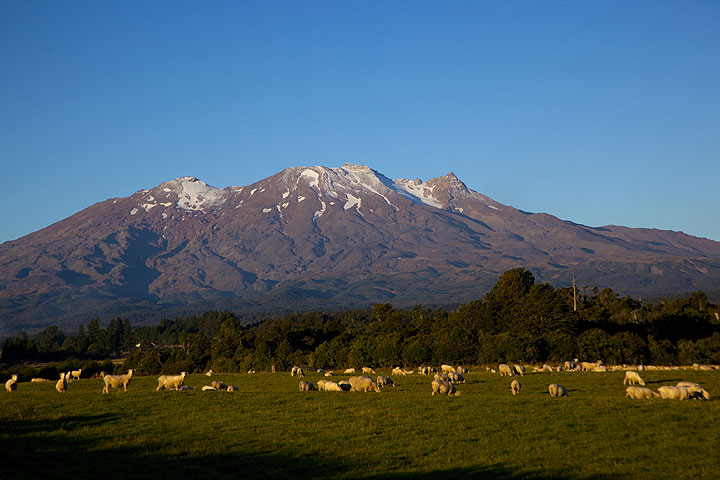
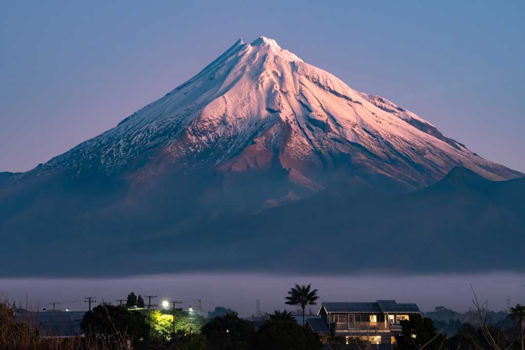
| Ruapehu | 1 | New Zealand (North Island) 39.28°S / 175.57°E | ||||
| Ruapehu | 1 | New Zealand (North Island) 39.28°S / 175.57°E | ||||
| Monowai | 0 | Kermandec Islands, New Zealand | ||||
| Raoul Island Green Lake crater | 1? | Kermandec Islands, New Zealand | ||||
| Monowai | 0 | Kermandec Islands, New Zealand | ||||
| Monowai | 0 | Kermandec Islands, New Zealand | ||||
| Monowai | 0 | Kermandec Islands, New Zealand | ||||
| White Island MH vent | 2 | Bay of Plenty, New Zealand | ||||
| White Island MH vent | 3? | Bay of Plenty, New Zealand | ||||
The last volcanic eruption in New Zealand was from White Island volcano in 2024.
The first historically documented eruption occurred 1814 from Raoul Island volcano.
Volcanoes in New Zealand erupt almost every year. Since the first historically documented eruption 1814in New Zealand, historic sources have shown nearly continuous volcanic activity: The Global Volcanism Project counts 223 historic eruptions until now, spanning a total of 138 out of 211 years. In other words, a volcano in New Zealand is active roughly every one in 1.5 years on average. This value is likely underestimated, because the record of historically documented activity is likely inclomplete the further back in time we look.
New Zealand is volcanically extremely active: Since 1900, at least 8 volcanoes in New Zealand have been active. Almost every year, at least one volcano has erupted in New Zealand. The last volcano to erupt in New Zealand was White Island volcano, which erupted in 2024, 4 months ago.
The largest eruption in New Zealand in historic times was from Okataina (Tarawera) volcano. It occurred in 1886. It ranks as a plinian eruption with a magnitude 5 on the VEI (Volcanic Explosivity Index) scale. Eruption of this size are often catastrophic on a regional scale.
| Date and Time | Mag / Depth | Nearest Volcano / Location | |||
|---|---|---|---|---|---|
| Apr 23, 01:01 pm (GMT -12) | 4.7 423 km | 11 km (6.8 mi) NW of | New Zealand I FELT IT | Info | |
| Wednesday, April 23, 2025 GMT (1 quake) | |||||
| Apr 23, 11:48 pm (GMT +12) | 4.6 245 km | 68 km (42 mi) SW of | South Pacific Ocean, 141 km northeast of Tauranga, Bay of Plenty, New Zealand I FELT IT | Info | |
| Tuesday, April 22, 2025 GMT (1 quake) | |||||
| Apr 22, 09:25 pm (GMT +11) | 4.5 750 km | 756 km (470 mi) SW of | New Zealand I FELT IT | Info | |
| Saturday, April 19, 2025 GMT (1 quake) | |||||
| Apr 20, 05:07 am (GMT +13) | 4.6 591 km | 121 km (75 mi) W of | New Zealand I FELT IT | Info | |
| Friday, April 18, 2025 GMT (2 quakes) | |||||
| Apr 19, 10:03 am (GMT +12) | 4.8 33 km | 157 km (98 mi) E of | New Zealand I FELT IT | Info | |
| Apr 19, 12:37 am (GMT +12) | 5.1 285 km | 48 km (30 mi) SW of | New Zealand I FELT IT | Info | |
| Date | Mag | Region | Deaths | Damage | |
|---|---|---|---|---|---|
| 2011 Feb 21 | 6.1 | Christchurch, Lyttelton | 185 | catastrophic | Info |
| 1931 Feb 2 | 7.7 | Hawke Bay | 261 | heavy | Info |
| 1929 Jun 16 | 7.5 | South Island | 17 | moderate | Info |
The deadliest earthquake in New Zealand since 1900 was the magnitude 7.7 earthquake in ![]() New Zealand, Hawke's Bay on Feb, 2, 1931. It resulted in 261 fatalities and 400 injured people. A tsunami was generated by the quake as well and contributed to its desctuctive effects. The height of the tsunami waves reached 15 m (49 ft). This was the most disastrous quake in New Zealand ever recorded.
New Zealand, Hawke's Bay on Feb, 2, 1931. It resulted in 261 fatalities and 400 injured people. A tsunami was generated by the quake as well and contributed to its desctuctive effects. The height of the tsunami waves reached 15 m (49 ft). This was the most disastrous quake in New Zealand ever recorded.
The earthquake that caused most damage was the magnitude 6.1 earthquake in ![]() New Zealand, Canterbury on Feb, 21, 2011. It caused 185 fatalities and estimated $15 billion US Dollars (today's equivalent) in total economic damage.
New Zealand, Canterbury on Feb, 21, 2011. It caused 185 fatalities and estimated $15 billion US Dollars (today's equivalent) in total economic damage.
Since 1900, at least 10 earthquakes claimed an estimated total of 473 fatalities in New Zealand.
There were 40 damaging or deadly quakes during this period that caused economic losses of approx. $28.8 billion US Dollars combined.