Menengai Volcano
Updated: Mar 31, 2025 14:44 GMT -
Shield volcano
Kenya, -0.2°S / 36.07°E 
Summit height: 2278 m / 7,474 ft
Current status: normal or dormant (1 out of 5)
[smaller] [larger]
Menengai volcano eruptions: 6050 BC (?)
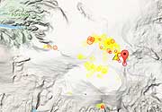
Latest nearby earthquakes
| Date and Time | Mag / Depth | Distance / Location | |||
|---|---|---|---|---|---|
Background
The massive Menengai shield volcano occupies the floor of the East African Rift. Construction of a 30 cu km shield volcano beginning about 200,000 years ago was followed by the eruption of two voluminous ash-flow tuffs, each preceded by major pumice falls. The first took place about 29,000 years ago and produced a large caldera. The second major eruption, producing about 30 cu km of compositionally zoned peralkaline trachytic magma about 8000 years ago, was associated with formation of the present-day 12 x 8 km summit caldera. More than 70 post-caldera lava flows cover the caldera floor, the youngest of which may be only a few hundred years old. No historical eruptions are known from Menengai. Fumarolic activity is restricted to the caldera.---
Smithsonian / GVP volcano information
Significant volcanic eruptions: Menengai volcano
No historic eruptions are known from Menengai volcano, but evidence from at least 2 eruptions during the past 10,000 years can be found in the geological record.
The table below lists all known eruptions (date in bold face) of Menengai volcano in historic times and during the past 10,000 years. Updates on the most recent volcanic activity of Menengai can be found on the news page of Menengai volcano.
| Date | Note | VEI | Deaths | Damage | |
|---|---|---|---|---|---|
| 6+ | |||||
| ? | |||||
Remark:
Our list of volcanic eruptions closely follows the database of eruptions of the Smithsonian's Global Volcanism Project (GVP), the internationally most recognized data source for volcanic eruptions, but also includes significant eruptive episodes or related volcano events. "Volcanic eruptions" are usually to be understood as sequences of individual eruptive episodes that can follow each other, or even overlap (if several vents are involved), and can last many years, decades or even longer. For example, the current activity of Stromboli volcano is understood as a single eruption that has been ongoing since 1934.
Sources: NOAA National Centers for Environmental Information (NCEI), Global Significant Volcanic Eruptions Database. doi:10.7289/V5TD9V7K | Global Volcanism Project / Smithsonian Institution
Menengai Volcano FAQ
+When was the last eruption of Menengai volcano?
The last confirmed eruption of Menengai occurred in 6050 BC.
+When was the largest eruption of Menengai volcano?
The largest eruption known from the younger geological history of Menengai volcano occurred in 6050 BC. It only has a VEI (Volcanic Explosivity Index) of , likely because it was a mainly effusive eruption generating lava flows but very little ash.
Latest satellite images
Menengai Volcano Maps
Below is a selection of maps showing the location and surroundings of the volcano at various resolutions based on aerial-imagery / terrain maps. Feel free to use them for non-commercial purposes on your blog or website as long as you credit them with a link back to this page (click to copy it).

Satellite/aerial-type map of Menengai volcano (world scale)

Terrain-type map of Menengai volcano (world scale)

Satellite/aerial-type map of Menengai volcano (region scale large)

Terrain-type map of Menengai volcano (region scale large)

Satellite/aerial-type map of Menengai volcano (region scale medium)

Terrain-type map of Menengai volcano (region scale medium)

Satellite/aerial-type map of Menengai volcano (region scale small)

Terrain-type map of Menengai volcano (region scale small)

Satellite/aerial-type map of Menengai volcano (local scale large)

Terrain-type map of Menengai volcano (local scale large)

Satellite/aerial-type map of Menengai volcano (local scale medium)

Terrain-type map of Menengai volcano (local scale medium)

Satellite/aerial-type map of Menengai volcano (local scale small)

Terrain-type map of Menengai volcano (local scale small)

Satellite/aerial-type map of Menengai volcano (scale of 10s of km)

Terrain-type map of Menengai volcano (scale of 10s of km)

Satellite/aerial-type map of Menengai volcano (scale of 20-40 km)

Terrain-type map of Menengai volcano (scale of 20-40 km)

Satellite/aerial-type map of Menengai volcano (scale of approx. 10-20 km)

Terrain-type map of Menengai volcano (scale of approx. 10-20 km)

Satellite/aerial-type map of Menengai volcano (scale of 5-10 km)

Satellite/aerial-type map of Menengai volcano (scale of few kilometers)