Harrat Kishb Volcano
Updated: Apr 17, 2025 23:59 GMT -
volcanic field
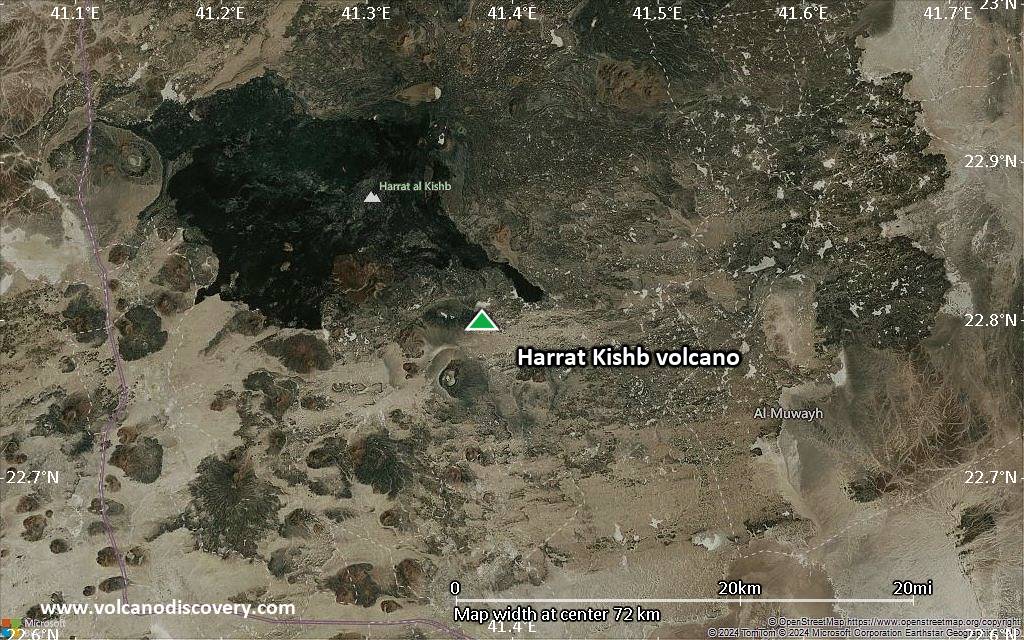
central Saudi Arabia, 22.8°N / 41.38°E 
Summit height: 1475 m / 4,839 ft
Current status: normal or dormant (1 out of 5)
Harrat Kishb volcano is a 5900 sq km volcanic field in central Saudi Arabia, east of the other N-S-trending chain of Harrats.
The volcanic field contains basaltic scoria cones, tuff rings, maars, lava domes and lava flows.
[smaller] [larger]
Harrat Kishb volcano eruptions: unknown, less than 10,000 years ago
Latest nearby earthquakes
| Date and Time | Mag / Depth | Distance / Location | |||
|---|---|---|---|---|---|
Background
Most of the Harrat Kishb volcanic field is of Pleistocene age. Young Holocene flows are restricted to 3 areas in the western half of the field.Jabal Aslaj cone and its associated lava flows contain abundant granitic blocks from basement rocks and ultramafic nodules. Jabal Hil is a large scoria cone with a 300-m-wide crater that was filled and overtopped by a lava lake.
Harrat Kishb includes several tuff rings and maars, including the 800 x 600 m wide Al Wabah maar in the west-central part of the Harrat. The most recent products of Harrat Kishb, which include the scoria cones and lava flows of Jabal Aslaj and Jabal Hil and the Jabal Shalman lava-dome, lava-flow, and scoria-cone complex, are stratigraphically younger than a pluvial period dated about 6500-4000 years before present. (from: Smithsonian / GVP)
The lava field contains a number of lava tubes, including Ghostly Cave (Kahf Al Ashbaah) and Kahf Al Mut'eb as some of the most known ones.
Latest satellite images

Harrat Kishb Volcano Maps
Below is a selection of maps showing the location and surroundings of the volcano at various resolutions based on aerial-imagery / terrain maps. Feel free to use them for non-commercial purposes on your blog or website as long as you credit them with a link back to this page (click to copy it).

Satellite/aerial-type map of Harrat Kishb volcano (world scale)

Terrain-type map of Harrat Kishb volcano (world scale)

Satellite/aerial-type map of Harrat Kishb volcano (region scale large)

Terrain-type map of Harrat Kishb volcano (region scale large)

Satellite/aerial-type map of Harrat Kishb volcano (region scale medium)

Terrain-type map of Harrat Kishb volcano (region scale medium)

Satellite/aerial-type map of Harrat Kishb volcano (region scale small)

Terrain-type map of Harrat Kishb volcano (region scale small)

Satellite/aerial-type map of Harrat Kishb volcano (local scale large)

Terrain-type map of Harrat Kishb volcano (local scale large)

Satellite/aerial-type map of Harrat Kishb volcano (local scale medium)

Terrain-type map of Harrat Kishb volcano (local scale medium)

Satellite/aerial-type map of Harrat Kishb volcano (local scale small)

Terrain-type map of Harrat Kishb volcano (local scale small)
Satellite/aerial-type map of Harrat Kishb volcano (scale of 10s of km)

Terrain-type map of Harrat Kishb volcano (scale of 10s of km)

Satellite/aerial-type map of Harrat Kishb volcano (scale of 20-40 km)

Terrain-type map of Harrat Kishb volcano (scale of 20-40 km)

Satellite/aerial-type map of Harrat Kishb volcano (scale of approx. 10-20 km)

Terrain-type map of Harrat Kishb volcano (scale of approx. 10-20 km)

Satellite/aerial-type map of Harrat Kishb volcano (scale of 5-10 km)

Satellite/aerial-type map of Harrat Kishb volcano (scale of few kilometers)