| RSS | EN | DE | EL | ES | FR | IT | RU

Volcanoes of El Salvador (30)

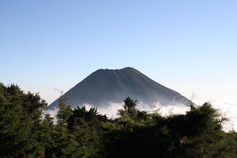
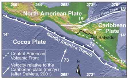
There are 20 potentially active volcanoes in El Salvador. They belong to the circum-pacific Ring of Fire, and are related to the oblique subduction of the oceanic Cocos Plate under the Caribbean tectonic plate.

[hide/show quakes] | [smaller] [bigger]

Significant volcanic eruptions: El Salvador

In historic times, at least 5 volcanoes have been active in El Salvador, including San Miguel, Santa Ana, and Izalco volcanoes. A total of 108 eruptions have been witnessed and documented since around 1510 AD.
The table below lists the most recent volcanic eruptions, significant eruptive episodes or related events in El Salvador since 1900.
DateVolcanoVEIRegionDeathsDamage
2022 Nov 15 - 2023 May 27San Miguel2El Salvador
2020 Feb 22San Miguel1El Salvador
2018 Jan 14 - Mar 4 ±4 d.San Miguel
Summit crater
1El Salvador
2017 Jan 7San Miguel
Summit crater
1El Salvador
2016 Jun 18San Miguel
Summit crater
1El Salvador
2016 Jan 12 - Jan 18San Miguel
Summit crater
1El Salvador
2015 Aug 13San Miguel
Summit crater
1El Salvador
2015 Jan 26 - Apr 11San Miguel
Summit crater
1El Salvador
2013 Dec 29 - 2014 Jul 28San Miguel
Summit Crater
3El Salvador
2005 Jun 16 - Oct 1 ?Santa Ana3El Salvador
2005 Oct 1
(eruption 2005 Jun 16 - Oct 1 ?)
Santa Ana3El Salvador2
Info
2002 Jan 16San Miguel1El Salvador
1997 Dec 31San Miguel1El Salvador
1995 Jan 12 - Apr 19San Miguel1El Salvador
1985 Nov 16 ±15 d. - 1986 Feb 16 ±15 d.San Miguel1El Salvador
1976 Dec 2 - 1977 Mar 1San Miguel1El Salvador
1970 Mar 30 - Apr 5San Miguel1El Salvador
1967 Jan 5San Miguel2El Salvador
1966 Oct 28 - Nov 16 ±15 d.Izalco
SSE flank (550 m below summit)
0El Salvador
1966 Jul 16 ±15 d.San Miguel2El Salvador
1966 Feb 22San Miguel2El Salvador
1965 Jun 14San Miguel
Summit crater
2El Salvador
1964 Oct 23 - Nov 16 ±15 d.San Miguel2El Salvador
1948 Nov 4 - 1957 Dec 1 ±30 d.Izalco
Summit, SW and NE flanks
3El Salvador
1954 Oct 21San Miguel2El Salvador
1939 Feb - 1948 FebIzalco
Summit and SSE flank
2El Salvador
1939 May - JulSan Miguel2El Salvador
1937 ? - 1938 ?Izalco2?El Salvador
1933 Nov 30 - 1934 Jan 12 or laterIzalco2El Salvador
1931 Mar - JunSan Miguel2El Salvador
1931 Mar 31 ±90 d.Izalco2El Salvador
1930 AprIzalco
Outer slope of eastern summit crater
?El Salvador
1930 Jan 26 ±5 d.San Miguel2El Salvador
1929 AugSan Miguel2El Salvador
1927 - 1928 ?Izalco2El Salvador
1925 Dec 26 - 1927 JanIzalco3?El Salvador
1920 Aug 14 - 1925San Miguel2El Salvador
1924 MarIzalco2El Salvador
1920 Oct 29 - 1921 Apr 10Izalco
SE flank
2El Salvador
1920 Oct 29
(eruption 1920 Oct 29 - 1921 Apr 10)
Izalco3El Salvador1-50 (*)
Info
1919 Dec 10 - 1920 JanSan Miguel2El Salvador
1917 Jun 7 - NovSan Salvador
Boquerón summit and north flank
3El Salvador
1917 Jun 7
(eruption 1917 Jun 7 - Nov)
San Salvador3El Salvador325
Info
1912 Jan 16 - 1916 Jan 26Izalco
Summit and NE flank
2El Salvador
1903 Nov - 1905 MarIzalco
Summit and east flank
2El Salvador
1904 Jan 12 - Jan 26 ?Santa Ana2El Salvador
1902 May 10 - Dec 30Izalco
Summit and NE flank
2El Salvador
1899 Dec 31 - 1900 MarIzalco2El Salvador
(*) Estimated numbers
Remark:
Our list of volcanic eruptions closely follows the database of eruptions of the Smithsonian's Global Volcanism Project (GVP), the internationally most recognized data source for volcanic eruptions, but also includes significant eruptive episodes or related volcano events. "Volcanic eruptions" are usually to be understood as sequences of individual eruptive episodes that can follow each other, or even overlap (if several vents are involved), and can last many years, decades or even longer. For example, the current activity of Stromboli volcano is understood as a single eruption that has been ongoing since 1934.
Sources: NOAA National Centers for Environmental Information (NCEI), Global Significant Volcanic Eruptions Database. doi:10.7289/V5TD9V7K | Global Volcanism Project / Smithsonian Institution

El Salvador FAQ

+When was the last volcanic eruption in El Salvador?

+When was the first documented volcanic eruption in El Salvador?

+How often do volcanoes in El Salvador erupt?

+How active are the volcanoes in El Salvador?

+When was the largest volcanic eruption in El Salvador?

Latest earthquakes: El Salvador

In the past 7 days, El Salvador was shaken by 4 quakes of magnitude 4.0 or above, 17 quakes between 3.0 and 4.0, and 15 quakes between 2.0 and 3.0. There were also 2 quakes below magnitude 2.0 which people don't normally feel.
A magnitude 4.8 quake was felt in North Pacific Ocean, El Salvador 5 days ago.
Date and TimeMag / DepthNearest Volcano / Location
Apr 28, 10:22 am (GMT -6)
1 day 18 hours ago
4.3

23 km
84 km (52 mi) S ofNorth Pacific Ocean, 79 km south of Santa Tecla, El SalvadorI FELT IT - 3 reportsInfo
Apr 28, 10:22 am (GMT -6)
1 day 18 hours ago
4.3

39 km
82 km (51 mi) S ofOffshore EL Salvador  I FELT IT - 1 reportInfo
Saturday, April 26, 2025 GMT (1 quake)
Apr 26, 08:54 am (GMT -6)
4 days ago
4.1

29 km
84 km (52 mi) S ofNorth Pacific Ocean, 76 km south of Usulutan, El SalvadorI FELT IT Info
Friday, April 25, 2025 GMT (1 quake)
Apr 25, 08:11 am (GMT -6)
5 days ago
4.8

63 km
70 km (43 mi) S of42 km SSW of La Libertad, El Salvador  I FELT IT - 24 reportsInfo
Thursday, April 24, 2025 GMT (2 quakes)
Apr 24, 06:10 am (GMT -6)
6 days ago
3.9

33 km
72 km (45 mi) S of44 km Al Suroeste De Delta Del Rio Lempa, El Salvador  I FELT IT Info
Apr 24, 06:10 am (GMT -6)
6 days ago
3.9

55 km
70 km (43 mi) S ofOffshore EL Salvador  I FELT IT Info

Significant Earthquakes in El Salvador since 1900


The deadliest earthquake in El Salvador since 1900 was the magnitude 5.4 earthquake in  El Salvador, Departamento de San Salvador on Oct, 10, 1986. It resulted in 1,100 fatalities and 20,000 injured people. This was the most disastrous quake in El Salvador ever recorded. This was also the most damaging earthquake that occurred in this time: total economic losses were estimated to the equivalent of $1.5 billion US Dollars. An unknown number houses and other buildings were destroyed and an unknown number damaged.

DateMagRegionDeathsDamage
2019 May 306.6 San Salvador1
light
Info
2018 May 65.4 La Union, San Miguel0
moderate
Info
2017 Apr 104.8 San Salvador, Soyapango1
light
Info
2015 Aug 94.5 Alegria0
moderate
Info
2011 Nov 245.1El Salvador-guatemala0
light
Info
2001 May 85.7 Conchagua1
moderate
Info
2001 Feb 136.6 San Juan Tepezontes-san Vicente-cojutep315
very heavy
Info
2001 Jan 137.7El Salvador; Guatemala844
very heavy
Info
1986 Oct 105.4 San Salvador1,100
catastrophic
Info
1982 Jun 196.2 San Salvador; Guatemala43
moderate
Info
1965 May 36.0 San Marcos125
heavy
Info
1937 Dec 26? Ahuachapan, Atiquizaya, Turin, La Puerta0
heavy
Info
1936 Dec 19? San Vicente400
unknown
Info
1932? Zacatecoluca, San Juan, Nonualco0
heavy
Info
1919 Apr 285.9 San Salvador50-100 (*)
heavy
Info
1917 Jun 86.7 San Salvador100-1,000 (*)
very heavy
Info
1902 Feb 267.0El Salvador-guatemala185
heavy
Info
(*) Estimated numbers
Source: NOAA National Centers for Environmental Information (NCEI), Global Significant Earthquake Database. doi:10.7289/V5TD9V7K

Map

Oldest quakes (until 1960) are shown in yellow, most recent (from 2000) in red.
[quakes -] [quakes +] [smaller] [bigger]

Significant Earthquakes in El Salvador FAQ

+Which was the deadliest earthquake in El Salvador since 1900?

+How many people were killed by earthquakes in El Salvador since 1900?

+How much damage did earthquakes cause in El Salvador since 1900?

Volcano List

Apaneca Range

(stratovolcanoes 2036 m / 6,680 ft)
Apaneca Range (Cuyanausul Range) is a group of E-W trending stratovolcanoes and geothermal areas located in western El Salvador, between the Santa Ana complex and the Guatemala border, about 6 km SE of Ahuachapin town. The volcanoes are basaltic-to-andesitic and Pleistocene and H... [more info]

Apastepeque

(volcanic field 700? m / 2,297 ft)
Apastepeque volcano is a young volcanic field 8 km north of San Vicente town in central El Salvador. The Volcanic features contains about 24 closely spaced cinder cones, lava flows, lava domes, and maars. The latter are now filled by lakes, such as Laguna de Apastepeque and Lagun... [more info]

Cerro Buena Vista

(Stratovolcano 750 m / 2461 ft)
[more info]

Cerro Cacahuatique

(Stratovolcano 1500 m / 4921 ft)
[more info]

Cerro Cinotepeque

(volcanic field 665 m / 2,182 ft)
Cerro Cinotepeque volcano is a group of 4 young cinder cones on both sides of Río Lempa, about 40 km north of San Salvador city.
Cerro Cinotepeque (also spelled Cinotepec) lies south of the river, 2 other cones, Cerro Santiago and Cerro Mosquito, immediately north of the ri... [more info]

Cerro las Tablas

(Stratovolcano(es) 782 m / 2566 ft)
[more info]

Cerro Lolotique

(Unknown 804 m / 2638 ft)
[more info]

Cerro Singüil

(cinder cones 957 m / 3,140 ft)
Cerro Singüil (also known as El Cerron) is a large scoria cone SE of Volcán Chingo in the interior valley of El Salvador near the Guatemalan border. The volcano has a well-preserved summit crater and belongs to a young volcanic field of cinder cones and explosion craters. [more info]

Cerro Yayantique

(Stratovolcano(es) 613 m / 2011 ft)
[more info]

Chinameca

(stratovolcano 1300 m / 4,265 ft)
Chinameca volcano (also known as El Pacayal) is a small stratovolcano next to the larger San Miguel volcano in eastern El Salvador. It is connected to San Miguel across a low saddle to the SE.
Chinameca is truncated by a 2-km-wide, steep-sided caldera, Laguna Seca el Pacay... [more info]

Coatepeque

(caldera 746 m / 2,447 ft)
Coatepeque volcano is a large 7 x 10 km wide caldera 50 km west of San Salvador city. The caldera is elongated in SE-NW direction, with walls rising up to 800 m above the floor in its southwestern part. An up to 120 m deep and 5 km diameter lake occupies the eastern part of the c... [more info]

Conchagua

(stratovolcano 1225 m / 4,019 ft)
Conchagua volcano (also known as Cochague) is an eroded stratovolcano on the western side of the Gulf of Fonseca in at the southeastern tip of El Salvador.
The main summit of Conchagua is Cerro del Ocote, but the secondary summit Cerro de La Bandera to the ENE of the elonga... [more info]

Conchagüita

(stratovolcano 505 m / 1,657 ft)
Conchagüita volcano at the SE tip of El Salvador forms a small 4-km-wide island in the Gulf of Fonseca separated from Conchagua volcano across a narrow strait.
The volcano is a sharp-topped cone with a 100-m-wide summit crater at the southern end and contains a young lava ... [more info]

Guazapa

(stratovolcano 1438 m / 4,718 ft)
Guazapa volcano an eroded basaltic stratovolcano 23 km NE of San Salvador city. It is not known whether the Pleistocene volcano is still active. It shows signs of intense erosion that have cut deep valleys into its flanks, suggestin a very long dormany period, and there is no cra... [more info]

Ilopango

(caldera 450 m / 1,476 ft)
Ilopango volcano is a 8x11 km wide caldera at the eastern margin of San Salvador city, El Salvador. It is elongated to the east, has 150-500 m high walls and contains the scenic Lake Ilopango, one of El Salvador's largest.
The caldera is the result of at least 4 large plini... [more info]

Isla Meanguera

(Stratovolcano(es) 468 m / 1535 ft)
[more info]

Isla Zacatillo

(Pyroclastic cone(s) 158 m / 518 ft)
[more info]

Izalco

(stratovolcano 1950 m / 6,398 ft)
Izalco volcano, El Salvador (image courtesy: Angela Rucker, USAID)
Izalco volcano was born in 1770 and is the youngest volcano in El Slavador. It formed on the southern flank of Santa Ana volcano located 45 km NW of San Salvador city.
Frequent strombolian eruptions and sometimes lava flows have built a largely unvegetated cone 650 m high w... [more info]

Laguna Aramuaca

(maar 181 m / 594 ft)
Laguna Aramuaca volcano is a lake-filled explosion crater (maar) 10 km SE of the city of San Miguel in southeastern El Salvador.
The crater is 1 km wide and might have formed less than 10,000 years. The phreatomagmatic eruptions that formed it left spectacular pyroclastic ... [more info]

Los Limones Volcanic Field

(Pyroclastic cone(s) 420 m / 1378 ft)
[more info]

Masahuat Volcanic Field

(Stratovolcano 1005 m / 3297 ft)
[more info]

San Diego

(volcanic field 781 m / 2,562 ft)
San Diego volcano is a young basaltic volcanic field near Lake Güija at the border between El Salvador and Guatemala. It contains cinder cones and unvegetated, fresh-looking lava flows.
The lava flows from San Diego volcanic field have created a natural dam to form Lake Güi... [more info]

San Miguel

(stratovolcano 2130 m / 6,988 ft)
San Miguel volcano (also known locally as Chaparrastique) in eastern El Salvador is a symmetrical stratovolcano and one of the most active volcanoes of the country. It rises majestically from near sea level to 2130 m elevation and forms a prominent land mark.
The volcano's ... [more info]

San Salvador

(stratovolcano 1893 m / 6,211 ft)
San Salvador volcano is a massive stratovolcano immediately northwestwest of El Salvador city. Its modern summit cone is also called the Boqueron stratovolcano. It formed within a 6 km wide caldera left by the collapse of the predecessor volcano about 40,000 years ago. Remnants o... [more info]

San Vicente

(stratovolcano 2182 m / 7,159 ft)
San Vicente volcano (also known as Chichontepec) is a twin-peaked stratovolcano SE of Lake Ilopango. It is the second highest volcano in El Salvador and probably still active although there are no known historical eruptions. There are many hot springs and fumaroles on the norther... [more info]

Santa Ana

(stratovolcano 2381 m / 7,812 ft)
Santa Ana (also known as Ilamatepec) volcano is a stratovolcano about 45 km west of San Salvador city. It is El Salvador's highest volcano and one of its most active.
The broad summit of Santa Ana has a beautiful array of concentric craters with crescent-shaped rims.
more info]

Taburete

(stratovolcano 1172 m / 3,845 ft)
Taburete volcano is a basaltic to basaltic-andesite stratovolcano rising above the Pacific coastal plain east of the Río Lempa in El Salvador, located at the SW end of a cluster of volcanoes between San Vincente and San Miguel volcanoes.
Volcan Taburete contains a well-pres... [more info]

Tecapa

(stratovolcano 1593 m / 5,226 ft)
Tecapa volcano a complex basaltic-to-andesitic stratovolcano in east-central El Salvador. It is located at the NW end of a cluster of volcanoes east of the Río Lempa between San Vicente and San Miguel volcanoes. [more info]

Unnamed

(Volcanic field 377 m / 1237 ft)
[more info]

Usulután

(stratovolcano 1449 m / 4,754 ft)
Usulután volcano is a stratovolcano in east-central El Salvador, at the SE end of a cluster of basaltic to basaltic-andesite stratovolcanoes between San Vicente and San Miguel volcanoes.
The volcano contains a broad 1.3-km-wide summit crater breached to the east. The flank... [more info]
Volcanoes & Earthquakes - new app for Android
Guaranteed tours
9-25 Jun 2025: Volcanoes and Spices - Sulawesi/Halmahera (Indonesia)
7-22 Jul 2025: From Krakatau to Bali - Java (Indonesia)
7-23 Jul 2025: Volcanoes and Spices - Sulawesi/Halmahera (Indonesia)
1-17 Aug 2025: Volcanoes and Spices - Sulawesi/Halmahera (Indonesia)
1-14 Oct 2025: Desert, salt and volcanoes - Danakil desert (Ethiopia)
4-12 Oct 2025: From Stromboli to Etna - Sicily and Eolian Islands (Italy)
6-21 Oct 2025: From Krakatau to Bali - Java (Indonesia)
3-19 Nov 2025: Volcanoes and Spices - Sulawesi/Halmahera (Indonesia)
= spaces available   = guaranteed   = few spaces left   = booked out
Latest news
Wed, 31 May 2023, 14:00

San Miguel volcano (Eastern El Salvador) - Smithsonian / USGS Weekly Volcanic Activity Report for 24 May-30 May 2023 (Continuing Activity)

MARN reported that seismicity at San Miguel was detected on 23 May and remained elevated. At 1647 on 27 May an explosion generated a gas-and-ash plume that rose 700 m; seismicity decreased afterwards. Sulfur dioxide emissions were as high as 400 tons per day that same day based on measurements from an instrument located on the W flank, and then decreased to 268 and below 100 tons per day on 28 and 29 May, respectively. ... Read all
Mon, 29 May 2023, 05:35

San Miguel volcano (El Salvador): near-constant eruptions continue

The explosion from San Miguel volcano on 27 May (image: Ministerio de Medio Ambiente)
The explosive eruption at the volcano continues at roughly regular intervals. ... Read all
Tectonic setting of El Salvador (from: Agostini et al, 2006)
Source:
Agostini et al (2006) "Tectonic and magmatic evolution of the active volcanic front in El Salvador: insight into the Berlín and Ahuachapán geothermal area", Geothermics, v.35, pp. 368–408
Try our free app!
Volcanoes & Earthquakes - new app for Android
Android | iOS version

More on VolcanoDiscovery

Why is there advertising on this site?

Support us - Help us upgrade our services!

We truly love working to bring you the latest volcano and earthquake data from around the world. Maintaining our website and our free apps does require, however, considerable time and resources.
We need financing to increase hard- and software capacity as well as support our editor team. We're aiming to achieve uninterrupted service wherever an earthquake or volcano eruption unfolds, and your donations can make it happen! Every donation will be highly appreciated. If you find the information useful and would like to support our team in integrating further features, write great content, and in upgrading our soft- and hardware, please make a donation (PayPal).

Planned features:Thanks to your past donations, these features have been added recently:
Download and Upgrade the Volcanoes & Earthquakes app to get one of the fastest seismic and volcano alerts online:
Android | IOS
Thank you!
Sources: VolcanoDiscovery / VolcanoAdventures and other sources as noted.
Use of material: Most text and images on our websites are owned by us. Re-use is generally not permitted without authorization. Contact us for licensing rights.
Volcanoes & Earthquakes
VolcanoDiscovery Home
Volcanoes | Earthquakes | Photos | Volcano News | | Shop | App
Adventure & Study Travel
Tours to Volcanoes and Volcanic Areas: walking tours, photo tours, study tours
Tours & Dates | FAQ | About us
Get our newsletter!
Company info
Contact | Legal info | Terms & conditions
Follow us
Follow us on facebook Follow us on Instagram Follow us on Bluesky Follow us on Twitter Visit our Youtube channel
EN | DE | EL | ES | FR | IT | RU
VolcanoDiscovery GmbH, Germany, Reg. nr.: HRB 103744, EU Tax Id: DE 297 465 123 owned and created by
Dr. Tom Pfeiffer, volcanologist, volcano photographer, tour organizer member of
IAVCEI
IAVCEI
Vulkanologische Gesellschaft
Volcanological Society
Ecotourism Greece
Ecotourism Greece
RUV insurance
Insured by R+V
VolcanoDiscovery © 2004-2025 All Rights Reserved | Privacy - Cookie Settings