| RSS | EN | DE | EL | ES | FR | IT | RU

Dalafilla Volcano

Updated: Mar 31, 2025 08:19 GMT -
stratovolcano
Ethiopia, 13.79°N / 40.55°E
Summit height: 613 m / 2011 ft
Current status: normal or dormant (1 out of 5)
Last update: 14 Dec 2021

Dalafilla (or Alu-Dalafilla) is a stratovolcano in the Erta Ale range, Ethiopia. It had a major effusive eruption on Nov 4, 2008 - one of the largest effusive eruptions in Africa during historic times.

[smaller] [larger]
Typical eruption style: effusive
Dalafilla volcano eruptions: Nov-Dec 2008

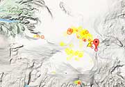
Latest nearby earthquakes

Date and TimeMag / DepthDistance / Location

Background

Dalaffilla (or Alu-Dalafilla), also called Gabuli, is one of the 6 volcanoes in the Erta Ale range in the northern Danakil desert in Ethiopia: Gada Ale, Alu-Dalaffilla, Borale Ale, Erta Ale, Hayli Gubbi and Ale Bagu.
Dalaffilla is a small conical stratovolcano with steep upper flanks and rises 300 m above surrounding lava fields SE of Alu volcano to 600 m above sea level.
Dalaffilla's shape with steep (up to ca. 35 deg) slopes is unusual for the Erta Ale Range volcanoes, which are mostly shield volcanoes made by basaltic lava flows. Dalafilla's cone is constructed of very viscous silicic flows that extend primarily to the east, while they are blocked to the west by tectonic morphologies. Numerous fissures surrounding the volcano have created lateral lava flows and constructed small cinder cones.
Fumarolic activity occurs in the 100-m-wide summit crater and has weathered surrounding lava flows.
The 2008 eruption started from a fissures on the rift axis between Dalaffilla and Alu volcanoes and produced enormous quantities of lava flows covering an estimated 300 square kilometers after the first days of the eruption. It is the first known eruption at Dalaffilla in historic times and likely to be one of the largest eruptions in the known history of Ethiopia.

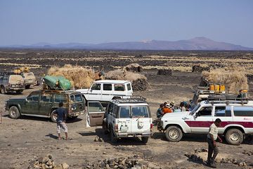
Dalafilla Volcano Photos

Significant volcanic eruptions: Dalafilla volcano

In the past 10,000 years, Dalafilla has had only one confirmed historic eruption in 2008.
The table below lists all known eruptions (date in bold face) of Dalafilla volcano in historic times and during the past 10,000 years. Updates on the most recent volcanic activity of Dalafilla can be found on the news page of Dalafilla volcano.
DateNoteVEIDeathsDamage
2008 Nov 3 - Dec 16 ±15 d.W and NW of Dalaffilla
Historical obs./docs.
3?
Remark:
Our list of volcanic eruptions closely follows the database of eruptions of the Smithsonian's Global Volcanism Project (GVP), the internationally most recognized data source for volcanic eruptions, but also includes significant eruptive episodes or related volcano events. "Volcanic eruptions" are usually to be understood as sequences of individual eruptive episodes that can follow each other, or even overlap (if several vents are involved), and can last many years, decades or even longer. For example, the current activity of Stromboli volcano is understood as a single eruption that has been ongoing since 1934.
Sources: NOAA National Centers for Environmental Information (NCEI), Global Significant Volcanic Eruptions Database. doi:10.7289/V5TD9V7K | Global Volcanism Project / Smithsonian Institution

Dalafilla Volcano FAQ

+When was the last eruption of Dalafilla volcano?

+How often does Dalafilla volcano erupt?

+How active is Dalafilla volcano at present?

+When was the largest eruption of Dalafilla volcano?

Latest satellite images

Dalafilla satellite image sat1Dalafilla satellite image sat2

Dalafilla Volcano Maps

Below is a selection of maps showing the location and surroundings of the volcano at various resolutions based on aerial-imagery / terrain maps. Feel free to use them for non-commercial purposes on your blog or website as long as you credit them with a link back to this page (click to copy it).
Satellite/aerial-type map of Dalafilla volcano (world scale)
Terrain-type map of Dalafilla volcano (world scale)
Satellite/aerial-type map of Dalafilla volcano (region scale large)
Terrain-type map of Dalafilla volcano (region scale large)
Satellite/aerial-type map of Dalafilla volcano (region scale medium)
Terrain-type map of Dalafilla volcano (region scale medium)
Satellite/aerial-type map of Dalafilla volcano (region scale small)
Terrain-type map of Dalafilla volcano (region scale small)
Satellite/aerial-type map of Dalafilla volcano (local scale large)
Terrain-type map of Dalafilla volcano (local scale large)
Satellite/aerial-type map of Dalafilla volcano (local scale medium)
Terrain-type map of Dalafilla volcano (local scale medium)
Satellite/aerial-type map of Dalafilla volcano (local scale small)
Terrain-type map of Dalafilla volcano (local scale small)
Satellite/aerial-type map of Dalafilla volcano (scale of 10s of km)
Terrain-type map of Dalafilla volcano (scale of 10s of km)
Satellite/aerial-type map of Dalafilla volcano (scale of 20-40 km)
Terrain-type map of Dalafilla volcano (scale of 20-40 km)
Satellite/aerial-type map of Dalafilla volcano (scale of approx. 10-20 km)
Terrain-type map of Dalafilla volcano (scale of approx. 10-20 km)
Satellite/aerial-type map of Dalafilla volcano (scale of 5-10 km)
Satellite/aerial-type map of Dalafilla volcano (scale of few kilometers)
Volcanoes & Earthquakes - new app for Android
Guaranteed tours
6-19 Apr 2025: Desert, salt and volcanoes - Danakil desert (Ethiopia)
12-19 Apr 2025: Europe's Volcanic Outpost - Canary Islands
9-25 Jun 2025: Volcanoes and Spices - Sulawesi/Halmahera (Indonesia)
27 Jun - 6 Jul 2025: Iceland Volcano Special - Iceland
7-23 Jul 2025: Volcanoes and Spices - Sulawesi/Halmahera (Indonesia)
1-17 Aug 2025: Volcanoes and Spices - Sulawesi/Halmahera (Indonesia)
13-26 Sep 2025: Green Volcanoes - Azores (Portugal)
1-14 Oct 2025: Desert, salt and volcanoes - Danakil desert (Ethiopia)
4-12 Oct 2025: From Stromboli to Etna - Sicily and Eolian Islands (Italy)
= spaces available   = guaranteed   = few spaces left   = booked out
Fri, 21 Nov 2008, 20:33

Dalaffilla volcano (Erta Ale range, Ethiopia), activity update: extensive lava flows

The eruption near Dalaffilla and Alu volcanoes on 3 November were reported by night-time satellite images. There was a multi-lobed lava-fieldwith a channel flowing to north-east. The source was a fissure northwest of Dalaffilla. The lava flowded area has a dimension of aproximately 9,3 x 15 km. Thermal anomalies showed that the lava-flow was also active during 12-16 November. ... Read all
Wed, 19 Nov 2008, 06:00

Alu-Dalafilla volcano (Ethiopia) - Smithsonian / USGS Weekly Volcanic Activity Report for 19 November-25 November 2008 (New Activity / Unrest)

During 19-24 November, the MODIS satellite continued to detect thermal anomalies over the area near Dalaffilla and Alu volcanoes from the eruption that began on 3 November. ... Read all

On this page:

Why is there advertising on this site?
Sources: VolcanoDiscovery / VolcanoAdventures and other sources as noted.
Use of material: Most text and images on our websites are owned by us. Re-use is generally not permitted without authorization. Contact us for licensing rights.
Volcanoes & Earthquakes
VolcanoDiscovery Home
Volcanoes | Earthquakes | Photos | Volcano News | App
Adventure & Study Travel
Tours to Volcanoes and Volcanic Areas: walking tours, photo tours, study tours
Tours & Dates | FAQ | About us
Get our newsletter!
Company info
Contact | Legal info | Terms & conditions
Follow us
Follow us on facebook Follow us on Instagram Follow us on Bluesky Follow us on Twitter Visit our Youtube channel
EN | DE | EL | ES | FR | IT | RU
VolcanoDiscovery GmbH, Germany, Reg. nr.: HRB 103744, EU Tax Id: DE 297 465 123 owned and created by
Dr. Tom Pfeiffer, volcanologist, volcano photographer, tour organizer member of
IAVCEI
IAVCEI
Vulkanologische Gesellschaft
Volcanological Society
Ecotourism Greece
Ecotourism Greece
RUV insurance
Insured by R+V
VolcanoDiscovery © 2004- All Rights Reserved | Privacy - Cookie Settings