| RSS | EN | DE | EL | ES | FR | IT | RU

Zao Volcano

Updated: Apr 22, 2025 05:45 GMT -
comlex volcano
Honshu (Japan), 38.14°N / 140.44°E
Summit height: 1841 m / 6,040 ft
Current status: normal or dormant (1 out of 5)
Last update: 21 Dec 2021 (Smithsonian / USGS Weekly Volcanic Activity Report)

Zao (or Zaozan, Zaosan) volcano is the most active volcano of northern Honshu and consists of a group of stratovolcanoes forming the crest of the divide between the Pacific Ocean and the Japan Sea.
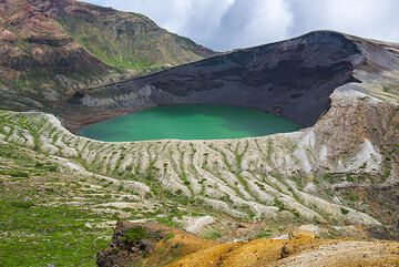
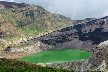
The older parts of the complex are Ryuzan volcano in the west and Byobu and Fubo volcanoes forming the southern group. Zao volcano proper (Chuo-Zao) is the youngest edifice and forms the central part of the group. One of its youngest summit lava domes is Goshiki-dake, which contains the active Okama crater, the source of most of the frequent historical eruptions recorded since the 8th century AD.
Okama crater contains a colorful, strongly acidic crater lake (pH 1.3).

[smaller] [larger]
Typical eruption style: explosive (phreatic)
Zao volcano eruptions: 1940, 1939 (?), 1927 (?), 1905, 1897 (?), 1896, 1895, 1895, 1894, 1890 (?), 1873, 1867, 1833, 1831, 1830, 1822, 1821, 1809, 1806, 1804, 1796, 1794, 1694, 1670, 1669, 1668, 1641, 1630, 1623-24, 1622, 1620, 1400 ± 100 years (radiocarbon), 1350 (?), 1331-33 (?), 1230, 1227, 1183, 884, 773 (?), 300 AD ± 200 (RC), 1600 BC (?, RC), 2000 BC ± 500 (tephrochronology), 2300 BC ± 75 (RC), 2600 BC ± 200 (RC), 3350 BC ± 50 (RC), 3850 BC ± 200 (RC), 4150 BC ± 200 (RC), 5500 BC (?, RC), 5600 BC (?, RC), 7600 BC (?, RC)

Latest nearby earthquakes

Date and TimeMag / DepthDistance / Location
Apr 17, 03:05 pm (GMT +9)
0.9

5.8 km
30 km (19 mi) to the N Japan: Southern Yamagata Pref Info
Apr 17, 09:37 am (GMT +9)
0.9

3.4 km
9.9 km (6.2 mi) to the W Japan: Southern Yamagata Pref Info
Thursday, April 10, 2025 GMT (1 quake)
Apr 10, 09:58 am (GMT +9)
1.0

3.4 km
9.6 km (6 mi) to the W Japan: Southern Yamagata Pref Info

Background

The Pleistocene Ryuzan volcano forms the western Zao group (Nishi-Zao), and Byobu and Fubo volcanoes form the southern Zao group (Minami-Zao). The complex was constructed over granitic basement rocks as high as 1500 m and thus has a relatively small volume. The 7 cu km Zao volcano proper forms the central ao group (Chuo-Zao), a volcanic complex topped by several lava domes and the Goshiki-dake tuff cone, aligned along a NW-SE trend. Several episodes of edifice collapse produced debris avalanches during the Pleistocene.

Zao Volcano Photos

Significant volcanic eruptions: Zao volcano

In the past 10,000 years, Zao has had at least 43 confirmed volcanic eruptions, out of which 31 are documented by historical records, while the others can be inferred from geological evidence.
Additionally, there are 9 uncertain or discredited eruptions from Zao volcano.
The table below lists all known eruptions (date in bold face) of Zao volcano since around 1800. Updates on the most recent volcanic activity of Zao can be found on the news page of Zao volcano.
DateNoteVEIDeathsDamage
1940 May 18Okama
Historical obs./docs.
1
?? 1939 Jul
Uncertain Eruption
1?
?? 1927
Uncertain Eruption
1?
1906
Discredited Eruption
1905Okama
Historical obs./docs.
1?
?? 1897 Jan 14
Uncertain Eruption
1?
?? 1896 Sep 1 ?
Uncertain Eruption
1?
1896 Mar 8Okama
Historical obs./docs.
1
1895 Aug 22 - Sep 28Okama
Historical obs./docs.
2
1895 Feb 15 - Mar 22Okama
Historical obs./docs.
1
1894 Jul 3Okama
Historical obs./docs.
2?
?? 1890
Uncertain Eruption
1?
1873 Aug - SepOkama
Historical obs./docs.
1?
1867 Oct 21Okama
Historical obs./docs.
2
1867 Oct 21
(eruption 1867 Oct 21)
Historical obs./docs.
23
Info
1833Okama
Historical obs./docs.
2
1831 Nov 22Okama
Historical obs./docs.
2
1830Okama
Historical obs./docs.
2
1822 May 1
Historical obs./docs.
?
1821 Jan 27 - May 1Okama
Historical obs./docs.
2
1809 Jun 12 - Dec 29Okama
Historical obs./docs.
2
1806 Jul 12Okama
Historical obs./docs.
2
1804 MayOkama
Historical obs./docs.
2
Remark:
Our list of volcanic eruptions closely follows the database of eruptions of the Smithsonian's Global Volcanism Project (GVP), the internationally most recognized data source for volcanic eruptions, but also includes significant eruptive episodes or related volcano events. "Volcanic eruptions" are usually to be understood as sequences of individual eruptive episodes that can follow each other, or even overlap (if several vents are involved), and can last many years, decades or even longer. For example, the current activity of Stromboli volcano is understood as a single eruption that has been ongoing since 1934.
Sources: NOAA National Centers for Environmental Information (NCEI), Global Significant Volcanic Eruptions Database. doi:10.7289/V5TD9V7K | Global Volcanism Project / Smithsonian Institution

Eruptions of Zao volcano


1992 earthquake
A M 4.7 earthquake occurred at 17h58 local time on 1 September a few kilometers ESE of the summit. There were no visible changes.

1990 seismic swarm
In July 1990, many small earthquakes were detected below the summit of Zao volcano.
(GVP)

1867 phreatic eruption and fatalities
On 21 Oct 1867, a phreatic eruption caused an overflow of muddy water from Okama crater lake, which killed 3 bathers who were in the hot springs at the foot of Goshiki-dake. ...more info

Zao Volcano FAQ

+When was the last eruption of Zao volcano?

+How often does Zao volcano erupt?

+How active is Zao volcano at present?

+When was the largest eruption of Zao volcano?

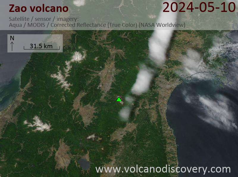
Latest satellite images

Zao satellite image sat1Zao satellite image sat2

Zao Volcano Maps

Below is a selection of maps showing the location and surroundings of the volcano at various resolutions based on aerial-imagery / terrain maps. Feel free to use them for non-commercial purposes on your blog or website as long as you credit them with a link back to this page (click to copy it).
Satellite/aerial-type map of Zao volcano (world scale)
Terrain-type map of Zao volcano (world scale)
Satellite/aerial-type map of Zao volcano (region scale large)
Terrain-type map of Zao volcano (region scale large)
Satellite/aerial-type map of Zao volcano (region scale medium)
Terrain-type map of Zao volcano (region scale medium)
Satellite/aerial-type map of Zao volcano (region scale small)
Terrain-type map of Zao volcano (region scale small)
Satellite/aerial-type map of Zao volcano (local scale large)
Terrain-type map of Zao volcano (local scale large)
Satellite/aerial-type map of Zao volcano (local scale medium)
Terrain-type map of Zao volcano (local scale medium)
Satellite/aerial-type map of Zao volcano (local scale small)
Terrain-type map of Zao volcano (local scale small)
Satellite/aerial-type map of Zao volcano (scale of 10s of km)
Terrain-type map of Zao volcano (scale of 10s of km)
Satellite/aerial-type map of Zao volcano (scale of 20-40 km)
Terrain-type map of Zao volcano (scale of 20-40 km)
Satellite/aerial-type map of Zao volcano (scale of approx. 10-20 km)
Terrain-type map of Zao volcano (scale of approx. 10-20 km)
Satellite/aerial-type map of Zao volcano (scale of 5-10 km)
Satellite/aerial-type map of Zao volcano (scale of few kilometers)
Volcanoes & Earthquakes - new app for Android
Guaranteed tours
9-25 Jun 2025: Volcanoes and Spices - Sulawesi/Halmahera (Indonesia)
27 Jun - 6 Jul 2025: Iceland Volcano Special - Iceland
7-23 Jul 2025: Volcanoes and Spices - Sulawesi/Halmahera (Indonesia)
1-17 Aug 2025: Volcanoes and Spices - Sulawesi/Halmahera (Indonesia)
1-14 Oct 2025: Desert, salt and volcanoes - Danakil desert (Ethiopia)
4-12 Oct 2025: From Stromboli to Etna - Sicily and Eolian Islands (Italy)
3-19 Nov 2025: Volcanoes and Spices - Sulawesi/Halmahera (Indonesia)
= spaces available   = guaranteed   = few spaces left   = booked out
Wed, 24 Jan 2018, 06:00

Zaozan [Zaosan] volcano (Honshu, Japan) - Smithsonian / USGS Weekly Volcanic Activity Report for 24 January-30 January 2018 (New Activity / Unrest)

JMA reported that tremor was detected at Zaozan on 28 and 30 January, and minor inflation at the S part of the volcano was recorded. There were 12 volcanic earthquakes detected on 31 January. JMA raised the Alert level to 2 (on a 5-level scale), noting the increased potential for a small eruption. ... Read all
Mon, 30 Nov 2015, 07:57

Zao volcano (Miyagi Prefecture, Japan): signs of internal unrest

Signs of unrest have been reported from the volcano. According to a news article, new episodes of volcanic tremor were detected under the volcano recently, believed to be signs of increased internal fluid movements. Read all

On this page:

Try our free app!
Volcanoes & Earthquakes - new app for Android
Android | iOS version

More on VolcanoDiscovery

Why is there advertising on this site?

Support us - Help us upgrade our services!

We truly love working to bring you the latest volcano and earthquake data from around the world. Maintaining our website and our free apps does require, however, considerable time and resources.
We need financing to increase hard- and software capacity as well as support our editor team. We're aiming to achieve uninterrupted service wherever an earthquake or volcano eruption unfolds, and your donations can make it happen! Every donation will be highly appreciated. If you find the information useful and would like to support our team in integrating further features, write great content, and in upgrading our soft- and hardware, please make a donation (PayPal).

Planned features:Thanks to your past donations, these features have been added recently:
Download and Upgrade the Volcanoes & Earthquakes app to get one of the fastest seismic and volcano alerts online:
Android | IOS
Thank you!
Sources: VolcanoDiscovery / VolcanoAdventures and other sources as noted.
Use of material: Most text and images on our websites are owned by us. Re-use is generally not permitted without authorization. Contact us for licensing rights.
Volcanoes & Earthquakes
VolcanoDiscovery Home
Volcanoes | Earthquakes | Photos | Volcano News | | Shop | App
Adventure & Study Travel
Tours to Volcanoes and Volcanic Areas: walking tours, photo tours, study tours
Tours & Dates | FAQ | About us
Get our newsletter!
Company info
Contact | Legal info | Terms & conditions
Follow us
Follow us on facebook Follow us on Instagram Follow us on Bluesky Follow us on Twitter Visit our Youtube channel
EN | DE | EL | ES | FR | IT | RU
VolcanoDiscovery GmbH, Germany, Reg. nr.: HRB 103744, EU Tax Id: DE 297 465 123 owned and created by
Dr. Tom Pfeiffer, volcanologist, volcano photographer, tour organizer member of
IAVCEI
IAVCEI
Vulkanologische Gesellschaft
Volcanological Society
Ecotourism Greece
Ecotourism Greece
RUV insurance
Insured by R+V
VolcanoDiscovery © 2004- All Rights Reserved | Privacy - Cookie Settings