| RSS | EN | DE | EL | ES | FR | IT | RU

Ukinrek Maars Volcano

Updated: Mar 26, 2025 09:22 GMT - 60 minutes ago refresh
Maars
United States, Alaska Peninsula, 57.83°N / -156.51°W
Summit height: 91 m / 299 ft
Current status: normal or dormant (1 out of 5)
Last update: 22 Dec 2021 (Smithsonian / USGS Weekly Volcanic Activity Report)

[smaller] [larger]
Typical eruption style: unspecified
Ukinrek Maars volcano eruptions: 1977 

Latest nearby earthquakes

Date and TimeMag / DepthDistance / Location
Mar 20, 06:39 am (Universal Time)
6 days ago
0.6

8.4 km
3.2 km (2 mi) to the N 65 km SE of Egegik, Alaska Info

Background

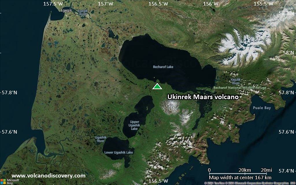
Ukinrek Maars are two explosion craters that were created in an area without previous volcanic activity during a 10-day-long phreatomagmatic eruption March-April 1977. The basaltic maars were erupted through glacial deposits in the Bering Sea lowlands 1.5 km south of Becharof Lake and 12 km west of Peulik volcano; their location is related to the regional Bruin Bay fault. The elliptical West Maar, which was the first to form, is 105 x 170 m wide and 35 m deep. The other maar, 600 m to the east, is 300 m wide and 70 m deep. Both maars are now filled by crater lakes; the eastern lake encircles a 49-m-high lava dome that was emplaced at the end of the eruption. Base surges were directed primarily to the NW. Juvenile material from the Ukinrek eruptions was of mantle-derived olivine basaltic composition. The dacitic Gas Rocks lava domes, of Quaternary age, are located on the shores of Becharof Lake, 3 km north of Ukinrek maars and were the site of a phreatic eruption about 2300 years ago.
---
Smithsonian / GVP volcano information

Significant volcanic eruptions: Ukinrek Maars volcano

In the past 10,000 years, Ukinrek Maars has had only one confirmed historic eruption in 1977 and one in 350 BC inferred from geological evidence.
The table below lists all known eruptions (date in bold face) of Ukinrek Maars volcano in historic times and during the past 10,000 years. Updates on the most recent volcanic activity of Ukinrek Maars can be found on the news page of Ukinrek Maars volcano.
DateNoteVEIDeathsDamage
1977 Mar 30 - Apr 9West and East Ukinrek Maars
Historical obs./docs.
3
350 ? BCGas Rocks?
Remark:
Our list of volcanic eruptions closely follows the database of eruptions of the Smithsonian's Global Volcanism Project (GVP), the internationally most recognized data source for volcanic eruptions, but also includes significant eruptive episodes or related volcano events. "Volcanic eruptions" are usually to be understood as sequences of individual eruptive episodes that can follow each other, or even overlap (if several vents are involved), and can last many years, decades or even longer. For example, the current activity of Stromboli volcano is understood as a single eruption that has been ongoing since 1934.
Sources: NOAA National Centers for Environmental Information (NCEI), Global Significant Volcanic Eruptions Database. doi:10.7289/V5TD9V7K | Global Volcanism Project / Smithsonian Institution

Ukinrek Maars Volcano FAQ

+When was the last eruption of Ukinrek Maars volcano?

+How often does Ukinrek Maars volcano erupt?

+How active is Ukinrek Maars volcano at present?

+When was the largest eruption of Ukinrek Maars volcano?

Latest satellite images

ukinrekmaars satellite image sat1ukinrekmaars satellite image sat2

Ukinrek Maars Volcano Maps

Below is a selection of maps showing the location and surroundings of the volcano at various resolutions based on aerial-imagery / terrain maps. Feel free to use them for non-commercial purposes on your blog or website as long as you credit them with a link back to this page (click to copy it).
Satellite/aerial-type map of Ukinrek Maars volcano (world scale)
Terrain-type map of Ukinrek Maars volcano (world scale)
Satellite/aerial-type map of Ukinrek Maars volcano (region scale large)
Terrain-type map of Ukinrek Maars volcano (region scale large)
Satellite/aerial-type map of Ukinrek Maars volcano (region scale medium)
Terrain-type map of Ukinrek Maars volcano (region scale medium)
Satellite/aerial-type map of Ukinrek Maars volcano (region scale small)
Terrain-type map of Ukinrek Maars volcano (region scale small)
Satellite/aerial-type map of Ukinrek Maars volcano (local scale large)
Terrain-type map of Ukinrek Maars volcano (local scale large)
Satellite/aerial-type map of Ukinrek Maars volcano (local scale medium)
Terrain-type map of Ukinrek Maars volcano (local scale medium)
Satellite/aerial-type map of Ukinrek Maars volcano (local scale small)
Terrain-type map of Ukinrek Maars volcano (local scale small)
Satellite/aerial-type map of Ukinrek Maars volcano (scale of 10s of km)
Terrain-type map of Ukinrek Maars volcano (scale of 10s of km)
Satellite/aerial-type map of Ukinrek Maars volcano (scale of 20-40 km)
Terrain-type map of Ukinrek Maars volcano (scale of 20-40 km)
Satellite/aerial-type map of Ukinrek Maars volcano (scale of approx. 10-20 km)
Terrain-type map of Ukinrek Maars volcano (scale of approx. 10-20 km)
Satellite/aerial-type map of Ukinrek Maars volcano (scale of 5-10 km)
Satellite/aerial-type map of Ukinrek Maars volcano (scale of few kilometers)
Volcanoes & Earthquakes - new app for Android
Guaranteed tours
6-19 Apr 2025: Desert, salt and volcanoes - Danakil desert (Ethiopia)
12-19 Apr 2025: Europe's Volcanic Outpost - Canary Islands
9-25 Jun 2025: Volcanoes and Spices - Sulawesi/Halmahera (Indonesia)
27 Jun - 6 Jul 2025: Iceland Volcano Special - Iceland
7-23 Jul 2025: Volcanoes and Spices - Sulawesi/Halmahera (Indonesia)
1-17 Aug 2025: Volcanoes and Spices - Sulawesi/Halmahera (Indonesia)
13-26 Sep 2025: Green Volcanoes - Azores (Portugal)
1-14 Oct 2025: Desert, salt and volcanoes - Danakil desert (Ethiopia)
4-12 Oct 2025: From Stromboli to Etna - Sicily and Eolian Islands (Italy)
= spaces available   = guaranteed   = few spaces left   = booked out
Wed, 12 May 2021, 06:00

Ukinrek Maars volcano (United States) - Smithsonian / USGS Weekly Volcanic Activity Report for 12 May-18 May 2021 (Continuing Activity)

On 12 May AVO changed the Aviation Color Code and Volcano Alert Level for Ukinrek-Maars to Green and Normal, respectively, reflecting that communication with seismic stations had been re-established, allowing for the location of earthquakes and detection of unrest. ... Read all
Wed, 14 Apr 2021, 06:00

Ukinrek Maars volcano (United States) - Smithsonian / USGS Weekly Volcanic Activity Report for 14 April-20 April 2021 (Continuing Activity)

AVO reported a loss of operation and communication with seismic stations that monitor Ukinrek-Maars, likely caused by snow cover. Both the Aviation Color Code and the Volcano Alert Level were changed to Unassigned on 19 April, reflecting the inability to locate earthquakes to detect unrest. Monitoring will continue with the remaining seismic stations, regional infrasound networks, lightning detection, and satellite images. ... Read all

On this page:

Why is there advertising on this site?
Sources: VolcanoDiscovery / VolcanoAdventures and other sources as noted.
Use of material: Most text and images on our websites are owned by us. Re-use is generally not permitted without authorization. Contact us for licensing rights.
Volcanoes & Earthquakes
VolcanoDiscovery Home
Volcanoes | Earthquakes | Photos | Volcano News | App
Adventure & Study Travel
Tours to Volcanoes and Volcanic Areas: walking tours, photo tours, study tours
Tours & Dates | FAQ | About us
Get our newsletter!
Company info
Contact | Legal info | Terms & conditions
Follow us
Follow us on facebook Follow us on Instagram Follow us on Bluesky Follow us on Twitter Visit our Youtube channel
EN | DE | EL | ES | FR | IT | RU
VolcanoDiscovery GmbH, Germany, Reg. nr.: HRB 103744, EU Tax Id: DE 297 465 123 owned and created by
Dr. Tom Pfeiffer, volcanologist, volcano photographer, tour organizer member of
IAVCEI
IAVCEI
Vulkanologische Gesellschaft
Volcanological Society
Ecotourism Greece
Ecotourism Greece
RUV insurance
Insured by R+V
VolcanoDiscovery © 2004-2025 All Rights Reserved | Privacy - Cookie Settings
Cookie-free, privacy-friendly web stats