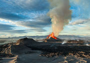
Contact | RSS | EN | DE | EL | ES | FR | IT | RU

Savai'i Volcano

Updated: Mar 14, 2025 04:48 GMT -
Shield volcano
Samoa, Samoan Islands, -13.61°S / -172.53°W
Summit height: 1858 m / 6,096 ft
Current status: normal or dormant (1 out of 5)

[smaller] [larger]
Typical eruption style: unspecified
Savai'i volcano eruptions: 1911 

Latest nearby earthquakes

Date and TimeMag / DepthDistance / Location

Background

Savai'i, the largest and highest of the Samoan islands, consists of a massive basaltic shield volcano constructed along a WNW-ESE-trending rift zone that splits into two rifts on the east side of the 75-km-long, oval-shaped island. Pliocene and Pleistocene shield formation was followed by stream and marine erosion, partial submergence, and growth of coral reefs. Late-stage Pleistocene and Holocene eruptions produced voluminous lava flows that partially buried fringing reefs. Numerous cinder cones and lava cones dot the broad crest of Savai'i, which has a low-angle, dome-like profile and reaches an elevation of 1858 m. Additional cones occur on the north-central flank, and a large number are found in the south-central part of the island. Three eruptions, including two in the 20th century, occurred in historical time, and produced voluminous lava flows that reached the northern coast along broad fronts up to about 15 km wide, destroying several villages and overtopping fringing reefs.
---
Smithsonian / GVP volcano information

Significant volcanic eruptions: Savai'i volcano

In the past 10,000 years, Savai'i has had at least 12 confirmed volcanic eruptions, out of which 3 are documented by historical records, while the others can be inferred from geological evidence.
The table below lists all known eruptions (date in bold face) of Savai'i volcano in historic times and during the past 10,000 years. Updates on the most recent volcanic activity of Savai'i can be found on the news page of Savai'i volcano.
DateNoteVEIDeathsDamage
1905 Aug 4 - 1911 NovMatavanu (north flank 402 m)
Historical obs./docs.
2
1907 Oct 6
(eruptive episode 1907 Oct 6)
Tsunami recorded
Historical obs./docs.
0
heavy
Info
1907 Jul 25
(eruption 1905 Aug 4 - 1911 Nov)
Tsunami recorded
Historical obs./docs.
2
Info
1907 Jul 9
(eruption 1905 Aug 4 - 1911 Nov)
Tsunami recorded
Historical obs./docs.
2
Info
1907 Jun 27
(eruption 1905 Aug 4 - 1911 Nov)
Tsunami recorded
Historical obs./docs.
2
Info
1907 Jun 19
(eruption 1905 Aug 4 - 1911 Nov)
Tsunami recorded
Historical obs./docs.
2
Info
1907 Jun 8
(eruption 1905 Aug 4 - 1911 Nov)
Tsunami recorded
Historical obs./docs.
2
Info
1906 Nov 28
(eruption 1905 Aug 4 - 1911 Nov)
Tsunami recorded
Historical obs./docs.
2
Info
1905 Aug 4
(eruption 1905 Aug 4 - 1911 Nov)
Tsunami recorded
Historical obs./docs.
2
heavy
Info
1902 Oct 30 - Nov 17 ±4 d.Mata Ole Afi (1649 m)
Historical obs./docs.
1
1760Mauga Afi (west-central Toasivi ridge)
Historical obs./docs.
2
1610 ±200 y. ADLe'ele?
1350 ±50 y. ADTafua Savai'i??
1310 ±50 y. AD?
1240 ±30 y. AD?
1040 ±150 y. AD?
170 ±100 y. AD?
480 ±300 y. BC?
1150 ±150 y. BC?
1990 ±150 y. BCNorth flank (Maugaloa)?
Remark:
Our list of volcanic eruptions closely follows the database of eruptions of the Smithsonian's Global Volcanism Project (GVP), the internationally most recognized data source for volcanic eruptions, but also includes significant eruptive episodes or related volcano events. "Volcanic eruptions" are usually to be understood as sequences of individual eruptive episodes that can follow each other, or even overlap (if several vents are involved), and can last many years, decades or even longer. For example, the current activity of Stromboli volcano is understood as a single eruption that has been ongoing since 1934.
Sources: NOAA National Centers for Environmental Information (NCEI), Global Significant Volcanic Eruptions Database. doi:10.7289/V5TD9V7K | Global Volcanism Project / Smithsonian Institution

Savai'i Volcano FAQ

+When was the last eruption of Savai'i volcano?

+How often does Savai'i volcano erupt?

+How active is Savai'i volcano at present?

+When was the largest eruption of Savai'i volcano?

Latest satellite images

savaii satellite image sat1savaii satellite image sat2

Savai'i Volcano Maps

Below is a selection of maps showing the location and surroundings of the volcano at various resolutions based on aerial-imagery / terrain maps. Feel free to use them for non-commercial purposes on your blog or website as long as you credit them with a link back to this page (click to copy it).
Satellite/aerial-type map of Savai'i volcano (world scale)
Terrain-type map of Savai'i volcano (world scale)
Satellite/aerial-type map of Savai'i volcano (region scale large)
Terrain-type map of Savai'i volcano (region scale large)
Satellite/aerial-type map of Savai'i volcano (region scale medium)
Terrain-type map of Savai'i volcano (region scale medium)
Satellite/aerial-type map of Savai'i volcano (region scale small)
Terrain-type map of Savai'i volcano (region scale small)
Satellite/aerial-type map of Savai'i volcano (local scale large)
Terrain-type map of Savai'i volcano (local scale large)
Satellite/aerial-type map of Savai'i volcano (local scale medium)
Terrain-type map of Savai'i volcano (local scale medium)
Satellite/aerial-type map of Savai'i volcano (local scale small)
Terrain-type map of Savai'i volcano (local scale small)
Satellite/aerial-type map of Savai'i volcano (scale of 10s of km)
Terrain-type map of Savai'i volcano (scale of 10s of km)
Satellite/aerial-type map of Savai'i volcano (scale of 20-40 km)
Terrain-type map of Savai'i volcano (scale of 20-40 km)
Satellite/aerial-type map of Savai'i volcano (scale of approx. 10-20 km)
Terrain-type map of Savai'i volcano (scale of approx. 10-20 km)
Satellite/aerial-type map of Savai'i volcano (scale of 5-10 km)
Satellite/aerial-type map of Savai'i volcano (scale of few kilometers)
Volcanoes & Earthquakes - new app for Android
Guaranteed tours
6-19 Apr 2025: Desert, salt and volcanoes - Danakil desert (Ethiopia)
12-19 Apr 2025: Europe's Volcanic Outpost - Canary Islands
9-25 Jun 2025: Volcanoes and Spices - Sulawesi/Halmahera (Indonesia)
27 Jun - 6 Jul 2025: Iceland Volcano Special - Iceland
7-23 Jul 2025: Volcanoes and Spices - Sulawesi/Halmahera (Indonesia)
1-17 Aug 2025: Volcanoes and Spices - Sulawesi/Halmahera (Indonesia)
13-26 Sep 2025: Green Volcanoes - Azores (Portugal)
1-14 Oct 2025: Desert, salt and volcanoes - Danakil desert (Ethiopia)
4-12 Oct 2025: From Stromboli to Etna - Sicily and Eolian Islands (Italy)
= spaces available   = guaranteed   = few spaces left   = booked out

No news in this list.

On this page:

Why is there advertising on this site?
Sources: VolcanoDiscovery / VolcanoAdventures and other sources as noted.
Use of material: Most text and images on our websites are owned by us. Re-use is generally not permitted without authorization. Contact us for licensing rights.
Volcanoes & Earthquakes
VolcanoDiscovery Home
Volcanoes | Earthquakes | Photos | Volcano News | App
Adventure & Study Travel
Tours to Volcanoes and Volcanic Areas: walking tours, photo tours, study tours
Tours & Dates | FAQ | About us
Get our newsletter!
Company info
Contact | Legal info | Terms & conditions
Follow us
Follow us on facebook Follow us on Instagram Follow us on Bluesky Follow us on Twitter Visit our Youtube channel
EN | DE | EL | ES | FR | IT | RU
VolcanoDiscovery GmbH, Germany, Reg. nr.: HRB 103744, EU Tax Id: DE 297 465 123 owned and created by
Dr. Tom Pfeiffer, volcanologist, volcano photographer, tour organizer member of
IAVCEI
IAVCEI
Vulkanologische Gesellschaft
Volcanological Society
Ecotourism Greece
Ecotourism Greece
RUV insurance
Insured by R+V
VolcanoDiscovery © 2004- All Rights Reserved | Privacy - Cookie Settings
Cookie-free, privacy-friendly web stats