| Data | Vulcano | VEI | Regione | Deceduti | Danni | |
|---|---|---|---|---|---|---|
| Dukono Malupang Magiwe and Malupang Warirang | 3 | Halmahera (Indonesia) | sconosciuto | |||
| Lewotobi | 2 | Flores (Indonesia) | sconosciuto | |||
| Semeru Jonggring Seloko | 4 | East Java, Indonesia | sconosciuto | |||
| Merapi | 1 | Central Java, Indonesia | sconosciuto | |||
| Marapi | 2 | Western Sumatra, Indonesia | sconosciuto | |||
| Ibu | 1 | Halmahera, Indonesia | sconosciuto | |||
| Raung | ? | East Java (Indonesia) | sconosciuto | |||
| Dempo | ? | Sumatra Island (Indonesia) | sconosciuto | |||
| Lewotolo | 2 | Lesser Sunda Islands (Indonesia) | sconosciuto | |||
| Dempo | 1 | Sumatra Island (Indonesia) | sconosciuto | |||
| Kerinci | 2 | Sumatra (Indonesia) | sconosciuto | |||
| Suoh | ? | Sumatra (Indonesia) | sconosciuto | |||
| 2024 Mag 11 (eruzione | Marapi | 0 | Western Sumatra, Indonesia | 67 | pesante | Info |
| Ruang | ? | Sangihe Islands, Indonesia | sconosciuto | |||
| Krakatau Anak Krakatau | 2 | Sunda Strait, Indonesia | sconosciuto | |||
| Bromo | 1 | East Java, Indonesia | sconosciuto | |||
| Karangetang Kawah Utama, Main Crater, South Crater | ? | Siau Island, Sangihe Islands, Indonesia | sconosciuto | |||
| Dempo | 2 | Sumatra Island (Indonesia) | sconosciuto | |||
| Marapi | 1 | Western Sumatra, Indonesia | sconosciuto | |||
| Kerinci | 2 | Sumatra (Indonesia) | sconosciuto | |||
| 2022 Dic 4 (eruzione | Semeru | 4 | East Java, Indonesia | leggero | Info | |
| Raung | 2 | East Java (Indonesia) | sconosciuto | |||
| Dempo | 1 | Sumatra Island (Indonesia) | sconosciuto | |||
| Sangeang Api | 2 | Flores Sea, Indonesia | sconosciuto | |||
| Karangetang Uncertain which summit crater | ? | Siau Island, Sangihe Islands, Indonesia | sconosciuto | |||
| 2021 Dic 4 (eruzione | Semeru | 4 | East Java, Indonesia | 45 | pesante | Info |
| Iliwerung | 0 | Lesser Sunda Islands (Indonesia) | sconosciuto | |||
| Sinabung | 3 | Sumatra, Indonesia | sconosciuto | |||
| Sirung | 1 | Pantar Island, Indonesia | sconosciuto | |||
| Kerinci | 1 | Sumatra (Indonesia) | sconosciuto | |||
| Dieng | 1 | Central Java (Indonesia) | sconosciuto | |||
| Raung | 2 | East Java (Indonesia) | sconosciuto | |||
| Karangetang Kawah Dua (North Crater, Second Crater) | 2 | Siau Island, Sangihe Islands, Indonesia | sconosciuto | |||
| Bromo | 1 | East Java, Indonesia | sconosciuto | |||
| Raung | 1 | East Java (Indonesia) | sconosciuto | |||
| Merapi | 3 | Central Java, Indonesia | sconosciuto | |||
| Sangeang Api Summit crater, Doro Api cone | 2 | Flores Sea, Indonesia | sconosciuto | |||
| Krakatau Anak Krakatau | 3 | Sunda Strait, Indonesia | sconosciuto | |||
| Soputan | 2 | North Sulawesi, Indonesia | sconosciuto | |||
| 2018 Dic 22 (eruzione | Krakatau | 3 | Sunda Strait, Indonesia | 437 | molto pesante | Info |
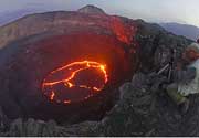
The last volcanic eruption nella Indonesia was from Raung volcano in 2024.
The first historically documented eruption occurred intorno 250 AD from Krakatau volcano.
Since 250 AD, Indonesia has seen at least 1295 historically documented eruptions. This means that a volcano erupts on average every 1.4 years.
Indonesia is volcanically extremely active: Since 1900, at least 68 volcanoes nella Indonesia have been active. Every year, at least one volcano has been in eruption nella Indonesia. The last volcano to erupt nella Indonesia was Raung volcano, which erupted in 2024, 3 months ago.
The largest eruption nella Indonesia in historic times was from Tambora volcano. It occurred during 1812 - 1815. It ranks as a very large plinian eruption with a magnitude 7 on the VEI (Volcanic Explosivity Index) scale. Eruption of this size can have catastrophic regional, or sometimes global consequences by disrupting climate globally over a few years. Eruption of this size are often catastrophic on a regional scale.
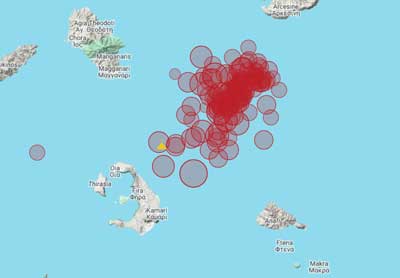
| Data e ora | Mag / Prof. | Vulcano più vicino / Posizione | |||
|---|---|---|---|---|---|
| 12 mar 21:51 (GMT +9) | 5.2 134 km | 65 km S da | Banda Sea I FELT IT - 1 report | Info | |
| 12 mar 19:55 (GMT +9) | 4.8 50 km | 394 km E da | West Papua Region, Indonesia I FELT IT | Info | |
| martedì, 11 marzo 2025 GMT (1 sismo) | |||||
| 11 mar 23:58 (GMT +9) | 4.9 49 km | 102 km O da | 126 km NW of Ternate, Indonesia I FELT IT | Info | |
| domenica, 9 marzo 2025 GMT (1 sismo) | |||||
| 9 mar 12:31 (GMT +8) | 4.8 65 km | 141 km S da | 114 km SSE of Sumbawa Besar, Indonesia I FELT IT - 18 reports | Info | |
| venerdì, 7 marzo 2025 GMT (2 sismi) | |||||
| 7 mar 18:42 (GMT +6) | 5.2 51 km | 117 km O da | Northern Sumatra, Indonesia I FELT IT - 1 report | Info | |
| 7 mar 16:34 (Makassar) | 5.0 10 km | 266 km S da | Kabupaten Luwu Timur, 106 km a nord est da Palopo, Indonesia I FELT IT - 3 reports | Info | |
| Data | Mag | Regione | Deceduti | Danni | |
|---|---|---|---|---|---|
| 2022 Nov 21 | 5.6 | W Java Cianjur | 635 | molto pesante | Info |
| 2018 Sep 28 | 7.5 | Sulawesi | 4,340 | catastrofico | Info |
| 2018 Aug 5 | 6.9 | Lombok Island | 560 | molto pesante | Info |
| 2010 Oct 25 | 7.8 | Sumatra | 431 | pesante | Info |
| 2009 Sep 30 | 7.5 | Sumatra Padang | 1,117 | catastrofico | Info |
| 2006 Jul 17 | 7.7 | Java | 802 | pesante | Info |
| 2006 May 26 | 6.3 | Java Bantul, Yogyakarta | 5,749 | catastrofico | Info |
| 2005 Mar 28 | 8.6 | Sumatera Sw | 1,313 | pesante | Info |
| 2004 Dec 26 | 9.1 | Sumatra Aceh Off West Coast | 227,899 | catastrofico | Info |
| 1992 Dec 12 | 7.8 | Flores Region, Maumere, Babi | 2,500 | molto pesante | Info |
| 1976 Jul 14 | 6.5 | Bali | 573 | molto pesante | Info |
| 1976 Jun 25 | 7.1 | New Guinea Irian Jaya | 6,000 | pesante | Info |
| 1969 Feb 23 | 7.0 | Sulawesi Parasanga, Paletoang | 664 | pesante | Info |
| 1926 Jul 5 | ? | Sumatra | 100-1,000 (*) | moderato | Info |
| 1926 Jun 28 | 5.8 | Sumatera | 100-1,000 (*) | moderato | Info |
| 1924 Dec 2 | ? | Java Wonosobo | 727 | pesante | Info |
| 1917 Jan 20 | 6.6 | Bali | 1,500 | moderato | Info |
| 1914 May 26 | 8.1 | New Guinea Irian Jaya Japen | 100-1,000 (*) | moderato | Info |
| 1909 Jun 3 | 7.6 | Sw Sumatra Kerintji, Redjanglebong | 100-1,000 (*) | pesante | Info |
| 1907 Jan 4 | 8.2 | Nw Sumatra Gunungsitoli, Barus | 2,188 | pesante | Info |
TIl terremoto più mortale nella Indonesia dal 1900 è stato the magnitude 9.1 earthquake nella ![]() Indonesia, Nanggroe Aceh Darussalam Province on dicembre, 26, 2004. Ha causato 227,899 vittime e between 100-1,000 feriti. La maggior parte delle vittime e dei danni è stata causata dallo tsunami seguito al terremoto.Lo tsunami ha raggiunto un'altezza d'acqua di 51 m. Questo era il 7° terremoto più mortale conosciuto nella storia umana e il terremoto più disastroso mai registrato nella Indonesia.
Indonesia, Nanggroe Aceh Darussalam Province on dicembre, 26, 2004. Ha causato 227,899 vittime e between 100-1,000 feriti. La maggior parte delle vittime e dei danni è stata causata dallo tsunami seguito al terremoto.Lo tsunami ha raggiunto un'altezza d'acqua di 51 m. Questo era il 7° terremoto più mortale conosciuto nella storia umana e il terremoto più disastroso mai registrato nella Indonesia.
Dal 1900, almeno 150 terremoti hanno causato un totale stimato di 260,000 vittime nella Indonesia.
In questo periodo ci sono stati 240 terremoti dannosi che hanno causato perdite economiche per ca. $20.6 miliardi di dollari americani combinato.
The archipelago of Indonesia consists of more than 13,000 islands, spread over an area that is similar in size to that of the continental United States. It is the country with the greatest number and density of active volcanoes.
Most volcanoes in Indonesia belong to the Sunda Volcanic Arc, streching over 3,000 kilometers from NW Sumatra to the Banda Sea. This volcanic arc results from the subduction of Indian Ocean crust beneath the Asian Plate and includes 76% of the region's volcanoes. To the NNW, the basaltic volcanism of the Andaman Islands results from short spreading centers, and to the east the Banda Arc reflects Pacific Ocean crust subducted westward. North of this arc, the tectonic setting is much more complex: several fragments of plates are converging to form multiple subduction zones, mainly oriented N-S. These produce the Sulawesi-Sangihe volcanoes on the west and Haimahera on the east of the collision zone.
Indonesia leads the world in many volcano statistics. It has the largest number of historically active volcanoes (76), its total of 1,171 dated eruptions is only narrowly exceeded by Japan's 1,274, although not much is know about the volcanic activity in the time before European colonialists arrived from the 15th century on. Indonesia has suffered the highest numbers of eruptions producing fatalities, damage to arable land, mudflows, tsunamis, domes, and pyroclastic flows. Four-fifths of Indonesian volcanoes with dated eruptions have erupted in this century.
Two of the most devastating volcanic eruptinos in historic time took place in Indonesia: the enormous eruption of Tambora in 1815,- the largest known eruption of the world during historical times,- had such far-reaching effects on the climate that for instance Europe was to experience 1816 as the year without summer. In 1883, the disastrous eruption of Krakatau carved itself deeply into the collective memory of mankind. The eruption of Krakatau was followed by severe tsunamis that killed about 30-40,000 people.
In 1920, a volcano survey was established by the Dutch-led government, leading to much improved volcano monitoring and reporting. The Volcanological Survey of Indonesia (VSI) now operates a network of 64 volcano observatories continuously monitoring 59 volcanoes.
---
Freely adapted from: Simkin and Siebert, 1994, Volcanoes of the World: Smithsonian Institution and Geoscience Press, Inc., Tucson, Arizona, 349p.