Contact | RSS | EN | DE | EL | ES | FR | IT | RU

Baru Volcano

Updated: Mar 14, 2025 17:38 GMT -
stratovolcano
Chiriquí Province, Panamá, 8.81°N / -82.54°W
Summit height: 3474 m / 11,397 ft
Current status: normal or dormant (1 out of 5)
View east to Volcán Barú, from 15 km distance. Foreground is hummocky terrain underlain by debris-avalanche deposits from Barú. Hachured lines approximate the headwall of ancient debris avalanche (from Sherrod et al 2007)

Barú volcano (also called Volcán de Chiriqui) is an active volcano 35 km east of the border to Costa Rica in the Talamanca Range of western in Panama. The complex, mainly andesitic stratovolcano is Panama´s highest peak.
A large explosive eruption occurred at about 700 AD destroyed settlements around the volcano. Excavations at the Cerro Punta archaeological site NW of the volcano have brought back to life their ruins.
The only historical eruption of Barú was an explosive eruption reported from the mid 16th century, but radiocarbon-dated tephra samples suggest that there was some activity less than 500 years ago.
Volcán Barú is the youngest major volcano in Panamá and there are geothermal exploration projects under way.

[smaller] [larger]
Typical eruption style: explosive
Baru volcano eruptions: 1550 ± 10
tephrochronology and radiocarbon-dated: 1340 ± 75, 1130 ± 150, 710 AD ± 30, 260 AD ± 150, 1270 BC ± 100, 7420 BC ± 75, 9280 BC ± 30 years

Latest nearby earthquakes

Date and TimeMag / DepthDistance / Location
Mar 4, 11:22 pm (Universal Time)
3.1

3 km
19 km (12 mi) to the N 51 km south of Changuinola, Bocas del Toro, Panama Info
Mar 4, 06:05 pm (Universal Time)
2.3

16 km
28 km (18 mi) to the SE 23 km north of David, Chiriqui, Panama Info

Background

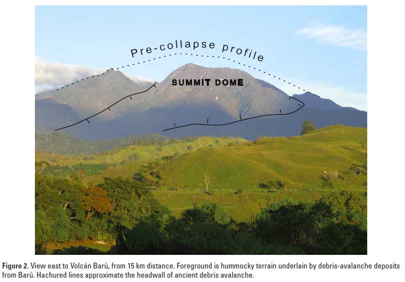
Volcán Barú is located south of the continental divide in the Cordillera de Talamanca of western Panamá. Its main edifice is the truncated remnant of a larger stratovolcano, which may have exceeded 4000 m elevation and partially collapsed during a large landslide probably more than 50,000 years ago.
Debris avalanche
The landslide formed a debris avalanche to the west reaching the Pacific coastal plain, and left a 6 km wide horseshoe-shaped summit caldera open to the west.
The avalanche deposit which originated from the amphitheatre truncating the cone is one of the larger and best exposed in Central America. It is reached 30 km length and 20 km width, and removed an estimated volume of 30 cubic km. The deposit of the flow is marked by a large area of hummocky terrain (hummocks are very large, internally intact blocks detached from the original mountain and left standing as small hills in the area of the landslide).

Post caldera lava domes formed inside the caldera and built up a new complex cone which is now higher than the original caldera rim. 10-20 m thick lava flows from Barú have reached 11 km distance of the summit.

Hazards at Baru volcano
(from Sherrod et al, 2007)
Barú with its 3,374 m altitude rises about 2,000 m above populated valleys to the west and about 2,400 m above those to the east. More than 10,000 people live in
areas immediately adjacent to the volcano, where the hazards from future eruptions are greatest. The heavily populated Pacific coastal plain, crossed by the Pan-American Highway, lies 30 km to the south.
Volcán Barú's eruptive episodes typically have included widespread tephra fallout, pyroclastic flows, and lahars. If such eruptions were to occur now, many people and costly infrastructure would be at risk.
Tephra fall
Prehistoric eruptions of Volcán Barú have repeatedly spread tephra blankets more than 100 km downwind and deposited thicknesses of 10 to 20 cm at distances 10 to 15 km downwind. A tephra fall of such magnitude can darken skies, cause panic among some residents, and ultimately cause roofs of some houses to collapse.
Pyroclastic flows
Pyroclastic flows have been common during eruptions of Volcán Barú. The type most common at Barú, block-and ash flows, has originated by the collapse of hot lava from the steep slopes of the summit lava dome. Block-and-ash flows of the past 1,600 years have descended westward from the summit area toward and through the present-day town of Volcán. Indeed, Volcán is built on block-and-ash flow deposits many meters thick. These block-and-ash flows have been limited
to an area within 15 km from their source at the summit dome
Some events, such as lahars and landslides (debris avalanches), can occur even when the volcano is not erupting.
Lahars
At Volcán Barú, many streams are incised in steep-sided canyons, so the damage from lahars trapped within them will be limited to the canyon itself. The largest lahars may reach to midslope altitudes on the plain from La Concepción to the
Río Caldera, where the canyons broaden and lose topographic relief. In this area the largest lahars can spread more widely.
In contrast, the Volcán area, although close to the volcano, lies upon a broad plain. Lahars from the mouth of the amphitheater would spread across this plain and then be funneled in the canyons of the Río Chiriquí Viejo and Río
Macho de Monte. Exceptionally large lahars may reach to the Río Gariché and then be funneled downvalley until they deplete their mass.
Landslides and lahars may cause problems for years after the original eruptions end. Once lahars have filled stream channels with sediment, the streams begin to erode new paths.

Source:
- Sherrod et al (2007) "Volcán Barú: Eruptive History and Volcano-Hazards Assessment", USGS Open-File Report 2007–1401
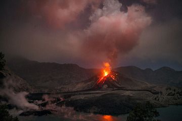
Baru Volcano Photos

Significant volcanic eruptions: Baru volcano

In the past 10,000 years, Baru has had only one confirmed historic eruption around 1550 AD, but at least 7 eruptions can be inferred from geological evidence.
The table below lists all known eruptions (date in bold face) of Baru volcano in historic times and during the past 10,000 years. Updates on the most recent volcanic activity of Baru can be found on the news page of Baru volcano.
DateNoteVEIDeathsDamage
1550 ±10 y. AD
Historical obs./docs.
?
1340 ±75 y. AD?
1130 ±150 y. AD?
710 ±30 y. AD?
260 ±150 y. AD?
1270 ±100 y. BC?
7420 ±75 y. BC?
9280 ±30 y. BC?
Remark:
Our list of volcanic eruptions closely follows the database of eruptions of the Smithsonian's Global Volcanism Project (GVP), the internationally most recognized data source for volcanic eruptions, but also includes significant eruptive episodes or related volcano events. "Volcanic eruptions" are usually to be understood as sequences of individual eruptive episodes that can follow each other, or even overlap (if several vents are involved), and can last many years, decades or even longer. For example, the current activity of Stromboli volcano is understood as a single eruption that has been ongoing since 1934.
Sources: NOAA National Centers for Environmental Information (NCEI), Global Significant Volcanic Eruptions Database. doi:10.7289/V5TD9V7K | Global Volcanism Project / Smithsonian Institution

Baru Volcano FAQ

+When was the last eruption of Baru volcano?

+How often does Baru volcano erupt?

Latest satellite images
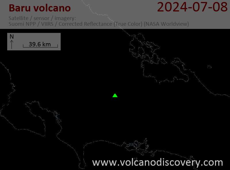
Baru satellite image sat1Baru satellite image sat2

Baru Volcano Maps

Below is a selection of maps showing the location and surroundings of the volcano at various resolutions based on aerial-imagery / terrain maps. Feel free to use them for non-commercial purposes on your blog or website as long as you credit them with a link back to this page (click to copy it).
Satellite/aerial-type map of Baru volcano (world scale)
Terrain-type map of Baru volcano (world scale)
Satellite/aerial-type map of Baru volcano (region scale large)
Terrain-type map of Baru volcano (region scale large)
Satellite/aerial-type map of Baru volcano (region scale medium)
Terrain-type map of Baru volcano (region scale medium)
Satellite/aerial-type map of Baru volcano (region scale small)
Terrain-type map of Baru volcano (region scale small)
Satellite/aerial-type map of Baru volcano (local scale large)
Terrain-type map of Baru volcano (local scale large)
Satellite/aerial-type map of Baru volcano (local scale medium)
Terrain-type map of Baru volcano (local scale medium)
Satellite/aerial-type map of Baru volcano (local scale small)
Terrain-type map of Baru volcano (local scale small)
Satellite/aerial-type map of Baru volcano (scale of 10s of km)
Terrain-type map of Baru volcano (scale of 10s of km)
Satellite/aerial-type map of Baru volcano (scale of 20-40 km)
Terrain-type map of Baru volcano (scale of 20-40 km)
Satellite/aerial-type map of Baru volcano (scale of approx. 10-20 km)
Terrain-type map of Baru volcano (scale of approx. 10-20 km)
Satellite/aerial-type map of Baru volcano (scale of 5-10 km)
Satellite/aerial-type map of Baru volcano (scale of few kilometers)
Volcanoes & Earthquakes - new app for Android
Guaranteed tours
6-19 Apr 2025: Desert, salt and volcanoes - Danakil desert (Ethiopia)
12-19 Apr 2025: Europe's Volcanic Outpost - Canary Islands
9-25 Jun 2025: Volcanoes and Spices - Sulawesi/Halmahera (Indonesia)
27 Jun - 6 Jul 2025: Iceland Volcano Special - Iceland
7-23 Jul 2025: Volcanoes and Spices - Sulawesi/Halmahera (Indonesia)
1-17 Aug 2025: Volcanoes and Spices - Sulawesi/Halmahera (Indonesia)
13-26 Sep 2025: Green Volcanoes - Azores (Portugal)
1-14 Oct 2025: Desert, salt and volcanoes - Danakil desert (Ethiopia)
4-12 Oct 2025: From Stromboli to Etna - Sicily and Eolian Islands (Italy)
= spaces available   = guaranteed   = few spaces left   = booked out

No news in this list.

On this page:

Why is there advertising on this site?
Sources: VolcanoDiscovery / VolcanoAdventures and other sources as noted.
Use of material: Most text and images on our websites are owned by us. Re-use is generally not permitted without authorization. Contact us for licensing rights.
Volcanoes & Earthquakes
VolcanoDiscovery Home
Volcanoes | Earthquakes | Photos | Volcano News | App
Adventure & Study Travel
Tours to Volcanoes and Volcanic Areas: walking tours, photo tours, study tours
Tours & Dates | FAQ | About us
Get our newsletter!
Company info
Contact | Legal info | Terms & conditions
Follow us
Follow us on facebook Follow us on Instagram Follow us on Bluesky Follow us on Twitter Visit our Youtube channel
EN | DE | EL | ES | FR | IT | RU
VolcanoDiscovery GmbH, Germany, Reg. nr.: HRB 103744, EU Tax Id: DE 297 465 123 owned and created by
Dr. Tom Pfeiffer, volcanologist, volcano photographer, tour organizer member of
IAVCEI
IAVCEI
Vulkanologische Gesellschaft
Volcanological Society
Ecotourism Greece
Ecotourism Greece
RUV insurance
Insured by R+V
VolcanoDiscovery © 2004- All Rights Reserved | Privacy - Cookie Settings
Cookie-free, privacy-friendly web stats