Ambrym Volcano
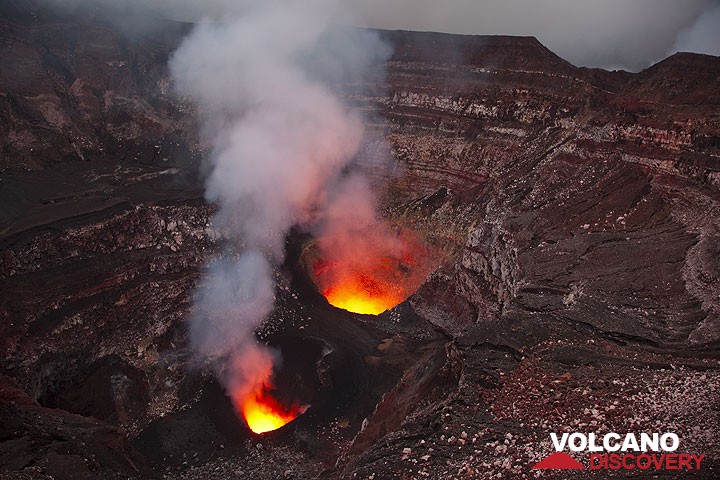
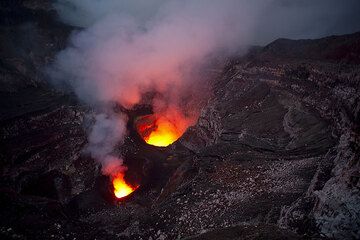
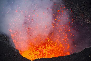
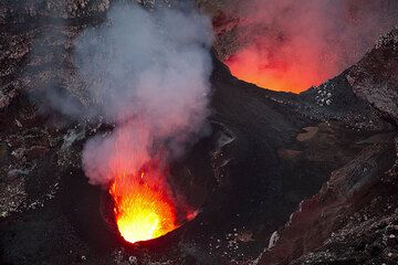
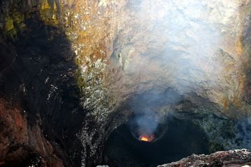
Ambrym is a large basaltic volcano with a 12-km-wide caldera. It is not only one of the most active volcanoes of Vanuatu, but in the world. Its most active craters often contain small lava lakes.
Ambrym volcano eruptions: 1774, 1820(?), 1863, 1870(?), 1871, 1883, 1884, 1886, 1888, 1894, 1898, 1908, 1909(?), 1910, 1912, 1913, 1915, 1929, 1935, 1937, 1938, 1942, 1950, 1952, 1953, 1954, 1955, 1957, 1958, 1960, 1961, 1963, 1964, 1967, 1971, 1972, 1973, 1977 (2x), 1979 (2x), 1980, 1981, 1983, 1984, 1986, 1988, 1989, 1990, 1994, 1996, 2006, 2008, 2009 -ongoing
Latest nearby earthquakes
| Date and Time | Mag / Depth | Distance / Location | |||
|---|---|---|---|---|---|
| Apr 4, 03:05 pm (Efate) | 3? 5 km | 26 km (16 mi) to the SE | Info | ||
| Apr 4, 01:26 pm (Efate) | 3? 78 km | 21 km (13 mi) to the N | Info | ||
| Thursday, April 3, 2025 GMT (1 quake) | |||||
| Apr 3, 10:42 pm (Efate) | 3? 192 km | 23 km (14 mi) to the NW | Info | ||
Background
Ambrym is a large basaltic volcano with a 12-km-wide caldera. It is not only one of the most active volcanoes of Vanuatu, but also in the world.Ambrym's caldera is a wide, impressive moon-like landscape containing an ash plain, cut by innumerable erosion gullies and containing several active craters and recent lava flows.
The caldera is believed to have formed during a major plinian eruption with dacitic pyroclastic flows about 1900 years ago. Activity after the caldera formation was concentrated around two vents that have become large complex craters called Marum and Benbow. Often, both Marum and Benbow (as well as other craters) contain small lava lakes, which occasionally erupt lava flows onto the caldera floor, or even exit the caldera through erosion gaps.
The post-caldera eruptions have also formed a series of scoria cones and maars along a fissure system oriented ENE-WSW. Eruptions have apparently occurred almost yearly during historical time from cones within the caldera or from flank vents. However, from 1850 to 1950, reporting was mostly limited to extra-caldera eruptions that would have affected local populations.
Occasionally, explosive eruptions occur from the craters, mostly because of water-magma interaction. Such eruptions produce tall clouds of ash, and can cause serious health problems in the local population because the ash contaminates ground water.
Ambrym Volcano Photos
Significant volcanic eruptions: Ambrym volcano
There is one uncertain or discredited eruption in 1870 from Ambrym volcano.
| Date | Note | VEI | Deaths | Damage | |
|---|---|---|---|---|---|
Historical obs./docs. | ? | ||||
Historical obs./docs. | ? | ||||
| Benbow Crater Historical obs./docs. | 1 | ||||
| Benbow and Marum Historical obs./docs. | 2 | ||||
| 2018 Dec 15 (eruption | Historical obs./docs. | 2 | moderate | Info | |
| Marum (Mbwelesu) Historical obs./docs. | 2 | ||||
| Benbow, Marum, Niri Mbelesu, Mbwelesu Historical obs./docs. | 1 | ||||
| Benbow and Marum Historical obs./docs. | 1? | ||||
| Mbwelesu, Niri Mbwelesu, Niri Taten Historical obs./docs. | 2 | ||||
| Marum, Benbow, Niri Mbwelesu Taten Historical obs./docs. | 2 | ||||
| Benbow, Mbwelesu, Marum, Niri Taten Historical obs./docs. | 3 | ||||
| New cone 3 km east of Marum Historical obs./docs. | 2 | ||||
Historical obs./docs. | 2 | ||||
| Marum Historical obs./docs. | 2 | ||||
| Benbow, Marum Historical obs./docs. | 2 | ||||
| Marum Historical obs./docs. | 3 | ||||
| Benbow, Marum Historical obs./docs. | 2 | ||||
| Benbow Historical obs./docs. | 2 | ||||
Historical obs./docs. | 2 | ||||
Historical obs./docs. | 2 | ||||
| Benbow, Mbuelesu, Marum Historical obs./docs. | 3 | ||||
| Benbow, Marum Historical obs./docs. | 3 | ||||
| Marum, Benbow Historical obs./docs. | 2 | ||||
| Marum, Benbow, Mbuelesu Historical obs./docs. | 2 | ||||
| Marum, Benbow Historical obs./docs. | 2 | ||||
| Benbow, Marum Historical obs./docs. | 2 | ||||
| Benbow, Marum, south of Marum Historical obs./docs. | 3 | ||||
| Mbuelesu, Benbow, near Marum Historical obs./docs. | 1? | ||||
| Marum Historical obs./docs. | 2 | ||||
| Benbow and Marum Historical obs./docs. | 2? | ||||
| Benbow, Marum Historical obs./docs. | 1? | ||||
| Benbow Historical obs./docs. | 2 | ||||
| Benbow Historical obs./docs. | 2 | ||||
| Benbow, Mbuelesu, S flank of Benbow Historical obs./docs. | 2 | ||||
| Benbow Historical obs./docs. | 2 | ||||
| Benbow Historical obs./docs. | 4+ | ||||
| NW flank of Benbow Historical obs./docs. | 2 | ||||
| Benbow, Marum ? Historical obs./docs. | 2 | ||||
| Benbow and west flank Historical obs./docs. | 2 | ||||
| Benbow Historical obs./docs. | 2 | ||||
| Benbow, west flank, Marum Historical obs./docs. | 2 | ||||
| Marum, crater at SE point Historical obs./docs. | 2 | ||||
| 1913 Dec 6 (eruption | Historical obs./docs. | 3 | 21 | heavy | Info |
| Benbow, west flank, Marum Historical obs./docs. | 3 | ||||
| Marum ?, west flank ? Historical obs./docs. | ? | ||||
| Base of Marum Historical obs./docs. | 0? | ||||
Historical obs./docs. | 2? | ||||
Historical obs./docs. | 2? | ||||
Ambrym Volcano FAQ
+When was the last eruption of Ambrym volcano?
The last confirmed eruption of Ambrym occurred in 2024.
+How often does Ambrym volcano erupt?
Since 1774, Ambrym volcano has had at least 56 historically documented eruptions. This means that it erupts on average every 4.5 years.
Many eruptions of Ambrym have lasted more than one year. In total, the volcano has been in eruption during 89 out of 251 years until now. In other words, Ambrym has been active at least one in 2.8 years on average. Note that this value is likely an underestimate, because the known history of eruptions from Ambrym is likely incomplete, especially further back in time.
+How active is Ambrym volcano at present?
Ambrym volcano is extremely active: Since 1900, it has been frequently active, showing eruptive activity during 77 years out of 126 as of now. The last eruption was in 2024 and ended 5 months ago.
+When was the largest eruption of Ambrym volcano?
The largest eruption known from the younger geological history of Ambrym volcano occurred around 50 AD. It ranks as a sub-plinian eruption with a magnitude 4 on the VEI (Volcanic Explosivity Index) scale.
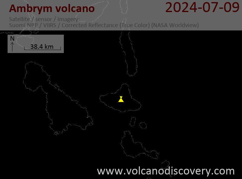
Latest satellite images

Price 5900 €
Ambrym Volcano Maps