Contact | RSS | EN | DE | EL | ES | FR | IT | RU

Ahyi Volcano

Updated: Mar 17, 2025 03:21 GMT -
Submarine volcano
United States, Mariana Islands, 20.42°N / 145.03°E
Summit height: -137 m / - 449 ft
Current status: normal or dormant (1 out of 5)
Last update: 12 Mar 2025 (Smithsonian / USGS Weekly Volcanic Activity Report)
3D model of Ahyi seamount volcano (image via GVP)

[smaller] [larger]
Typical eruption style: unspecified
Ahyi volcano eruptions: 1979?, 2001, 2014, 2022 (mid Oct - ongoing, to be confirmed)

Latest nearby earthquakes

Date and TimeMag / DepthDistance / Location

Background

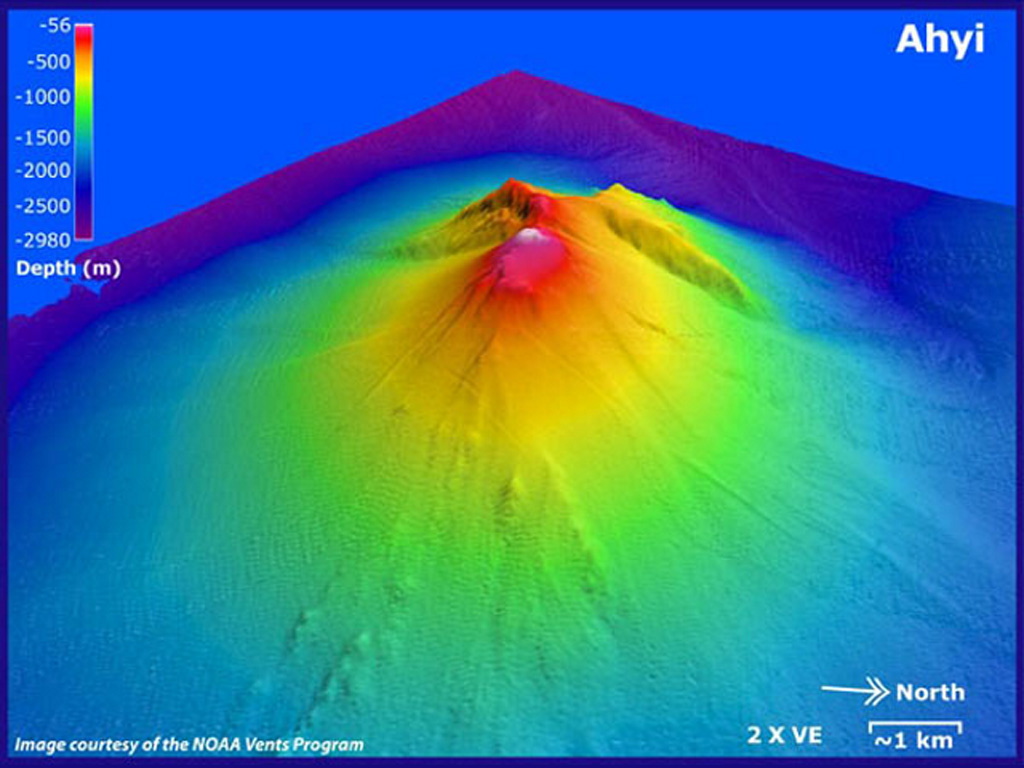
Ahyi seamount is a large conical submarine volcano that rises to within 137 m of the sea surface about 18 km SE of the island of Farallon de Pajaros (Uracas) in the northern Marianas. Water discoloration has been observed over the submarine volcano, and in 1979 the crew of a fishing boat felt shocks over the summit area of the seamount followed by upwelling of sulfur-bearing water. On April 24-25, 2001 an explosive submarine eruption was detected seismically from a seismic station on Rangiroa Atoll, Tuamotu Archipelago. The event was well constrained (+/- 15 km) at a location near the southern base of Ahyi; the summit of the seamount lies within the location uncertainty.
---
Smithsonian / GVP volcano information

Significant volcanic eruptions: Ahyi volcano

In the past 10,000 years, Ahyi has had at least 11 confirmed eruptions, all documented by historical records or observations. There is one uncertain or discredited eruption in 1979 from Ahyi volcano.
The table below lists all known eruptions (date in bold face) of Ahyi volcano in historic times and during the past 10,000 years. Updates on the most recent volcanic activity of Ahyi can be found on the news page of Ahyi volcano.
DateNoteVEIDeathsDamage
2024 Aug 5 -
Historical obs./docs.
?
2024 Jan 1 - Mar 27
Historical obs./docs.
?
2022 Nov 18 ±1 d. - 2023 Jun 11
Historical obs./docs.
1
2014 Apr 24 - May 17Summit crater and SE slope
Historical obs./docs.
2
2001 Apr 24 - Apr 25S of Ahyi (20.34 N, 145.02 E)
Historical obs./docs.
0
1994 Apr 23
Historical obs./docs.
0
1989 Sep 21 - Dec 27SW of Ahyi (~20.3 N, 144.9 E)
Historical obs./docs.
0
1985 Aug 2 - Sep 5SW of Ahyi
Historical obs./docs.
0
?? 1979 Nov 15
Uncertain Eruption
Historical obs./docs.
0
1969 Mar 11 - Mar 13S of Ahyi (20.24 N, 145.02 E)
Historical obs./docs.
0
1967 Mar 27 - Apr 10SW of Farallon de Pájaros
Historical obs./docs.
0
1934 Jul 15 ±45 d.Vicinity of Farallon de Pájaros
Historical obs./docs.
1
Remark:
Our list of volcanic eruptions closely follows the database of eruptions of the Smithsonian's Global Volcanism Project (GVP), the internationally most recognized data source for volcanic eruptions, but also includes significant eruptive episodes or related volcano events. "Volcanic eruptions" are usually to be understood as sequences of individual eruptive episodes that can follow each other, or even overlap (if several vents are involved), and can last many years, decades or even longer. For example, the current activity of Stromboli volcano is understood as a single eruption that has been ongoing since 1934.
Sources: NOAA National Centers for Environmental Information (NCEI), Global Significant Volcanic Eruptions Database. doi:10.7289/V5TD9V7K | Global Volcanism Project / Smithsonian Institution

Ahyi Volcano FAQ

+When was the last eruption of Ahyi volcano?

+How often does Ahyi volcano erupt?

+How active is Ahyi volcano at present?

+When was the largest eruption of Ahyi volcano?

Latest satellite images

ahyi satellite image sat1ahyi satellite image sat2

Ahyi Volcano Maps

Below is a selection of maps showing the location and surroundings of the volcano at various resolutions based on aerial-imagery / terrain maps. Feel free to use them for non-commercial purposes on your blog or website as long as you credit them with a link back to this page (click to copy it).
Satellite/aerial-type map of Ahyi volcano (world scale)
Terrain-type map of Ahyi volcano (world scale)
Satellite/aerial-type map of Ahyi volcano (region scale large)
Terrain-type map of Ahyi volcano (region scale large)
Satellite/aerial-type map of Ahyi volcano (region scale medium)
Terrain-type map of Ahyi volcano (region scale medium)
Satellite/aerial-type map of Ahyi volcano (region scale small)
Terrain-type map of Ahyi volcano (region scale small)
Satellite/aerial-type map of Ahyi volcano (local scale large)
Terrain-type map of Ahyi volcano (local scale large)
Satellite/aerial-type map of Ahyi volcano (local scale medium)
Terrain-type map of Ahyi volcano (local scale medium)
Satellite/aerial-type map of Ahyi volcano (local scale small)
Terrain-type map of Ahyi volcano (local scale small)
Satellite/aerial-type map of Ahyi volcano (scale of 10s of km)
Terrain-type map of Ahyi volcano (scale of 10s of km)
Satellite/aerial-type map of Ahyi volcano (scale of 20-40 km)
Terrain-type map of Ahyi volcano (scale of 20-40 km)
Satellite/aerial-type map of Ahyi volcano (scale of approx. 10-20 km)
Terrain-type map of Ahyi volcano (scale of approx. 10-20 km)
Satellite/aerial-type map of Ahyi volcano (scale of 5-10 km)
Satellite/aerial-type map of Ahyi volcano (scale of few kilometers)
Volcanoes & Earthquakes - new app for Android
Guaranteed tours
6-19 Apr 2025: Desert, salt and volcanoes - Danakil desert (Ethiopia)
12-19 Apr 2025: Europe's Volcanic Outpost - Canary Islands
9-25 Jun 2025: Volcanoes and Spices - Sulawesi/Halmahera (Indonesia)
27 Jun - 6 Jul 2025: Iceland Volcano Special - Iceland
7-23 Jul 2025: Volcanoes and Spices - Sulawesi/Halmahera (Indonesia)
1-17 Aug 2025: Volcanoes and Spices - Sulawesi/Halmahera (Indonesia)
13-26 Sep 2025: Green Volcanoes - Azores (Portugal)
1-14 Oct 2025: Desert, salt and volcanoes - Danakil desert (Ethiopia)
4-12 Oct 2025: From Stromboli to Etna - Sicily and Eolian Islands (Italy)
= spaces available   = guaranteed   = few spaces left   = booked out
Wed, 12 Mar 2025, 15:00

Ahyi volcano (United States) - Smithsonian / USGS Weekly Volcanic Activity Report for 5 March-11 March 2025 (Continuing Activity)

Unrest at Ahyi Seamount continued during 28 February-7 March. A plume of discolored water in the vicinity of the seamount was identified in a satellite image on 3 March, indicating possible submarine activity. Weather clouds obscured views during the rest of the week. ... Read all
Wed, 5 Mar 2025, 15:00

Ahyi volcano (United States) - Smithsonian / USGS Weekly Volcanic Activity Report for 26 February-4 March 2025 (Continuing Activity)

Unrest at Ahyi Seamount continued during 21-28 February. Occasional weak signals coming from the direction of Ahyi were identified in data from underwater pressure sensors near Wake Island (about 2,270 km E of Ahyi). The Aviation Color Code remained at Yellow (the second lowest level on a four-color scale) and the Volcano Alert Level remained at Advisory (the second lowest level on a four-level scale). ... Read all

On this page:

Why is there advertising on this site?
Sources: VolcanoDiscovery / VolcanoAdventures and other sources as noted.
Use of material: Most text and images on our websites are owned by us. Re-use is generally not permitted without authorization. Contact us for licensing rights.
Volcanoes & Earthquakes
VolcanoDiscovery Home
Volcanoes | Earthquakes | Photos | Volcano News | App
Adventure & Study Travel
Tours to Volcanoes and Volcanic Areas: walking tours, photo tours, study tours
Tours & Dates | FAQ | About us
Get our newsletter!
Company info
Contact | Legal info | Terms & conditions
Follow us
Follow us on facebook Follow us on Instagram Follow us on Bluesky Follow us on Twitter Visit our Youtube channel
EN | DE | EL | ES | FR | IT | RU
VolcanoDiscovery GmbH, Germany, Reg. nr.: HRB 103744, EU Tax Id: DE 297 465 123 owned and created by
Dr. Tom Pfeiffer, volcanologist, volcano photographer, tour organizer member of
IAVCEI
IAVCEI
Vulkanologische Gesellschaft
Volcanological Society
Ecotourism Greece
Ecotourism Greece
RUV insurance
Insured by R+V
VolcanoDiscovery © 2004- All Rights Reserved | Privacy - Cookie Settings
Cookie-free, privacy-friendly web stats