| Дата | Вулкан | VEI | Область | Летальные исходы | Ущерб | |
|---|---|---|---|---|---|---|
| Dukono Malupang Magiwe and Malupang Warirang | 3 | Halmahera (Indonesia) | неизвестно | |||
| Ibu | 1 | Halmahera, Indonesia | неизвестно | |||
| Lewotobi | 2 | Flores (Indonesia) | неизвестно | |||
| Semeru Jonggring Seloko | 4 | East Java, Indonesia | неизвестно | |||
| Merapi | 1 | Central Java, Indonesia | неизвестно | |||
| Marapi | 2 | Western Sumatra, Indonesia | неизвестно | |||
| Raung | ? | East Java (Indonesia) | неизвестно | |||
| Dempo | ? | Sumatra Island (Indonesia) | неизвестно | |||
| Lewotolo | 2 | Lesser Sunda Islands (Indonesia) | неизвестно | |||
| Dempo | 1 | Sumatra Island (Indonesia) | неизвестно | |||
| Kerinci | 2 | Sumatra (Indonesia) | неизвестно | |||
| Suoh | ? | Sumatra (Indonesia) | неизвестно | |||
| 2024 Май 11 (извержение | Marapi | 0 | Western Sumatra, Indonesia | 67 | тяжелое | Информация |
| Ruang | ? | Sangihe Islands, Indonesia | неизвестно | |||
| Krakatau Anak Krakatau | 2 | Sunda Strait, Indonesia | неизвестно | |||
| Bromo | 1 | East Java, Indonesia | неизвестно | |||
| Karangetang Kawah Utama, Main Crater, South Crater | ? | Siau Island, Sangihe Islands, Indonesia | неизвестно | |||
| Dempo | 2 | Sumatra Island (Indonesia) | неизвестно | |||
| Marapi | 1 | Western Sumatra, Indonesia | неизвестно | |||
| Kerinci | 2 | Sumatra (Indonesia) | неизвестно | |||
| 2022 Дек 4 (извержение | Semeru | 4 | East Java, Indonesia | легкое | Информация | |
| Raung | 2 | East Java (Indonesia) | неизвестно | |||
| Dempo | 1 | Sumatra Island (Indonesia) | неизвестно | |||
| Sangeang Api | 2 | Flores Sea, Indonesia | неизвестно | |||
| Karangetang Uncertain which summit crater | ? | Siau Island, Sangihe Islands, Indonesia | неизвестно | |||
| 2021 Дек 4 (извержение | Semeru | 4 | East Java, Indonesia | 45 | тяжелое | Информация |
| Iliwerung | 0 | Lesser Sunda Islands (Indonesia) | неизвестно | |||
| Sinabung | 3 | Sumatra, Indonesia | неизвестно | |||
| Sirung | 1 | Pantar Island, Indonesia | неизвестно | |||
| Kerinci | 1 | Sumatra (Indonesia) | неизвестно | |||
| Dieng | 1 | Central Java (Indonesia) | неизвестно | |||
| Raung | 2 | East Java (Indonesia) | неизвестно | |||
| Karangetang Kawah Dua (North Crater, Second Crater) | 2 | Siau Island, Sangihe Islands, Indonesia | неизвестно | |||
| Bromo | 1 | East Java, Indonesia | неизвестно | |||
| Raung | 1 | East Java (Indonesia) | неизвестно | |||
| Merapi | 3 | Central Java, Indonesia | неизвестно | |||
| Sangeang Api Summit crater, Doro Api cone | 2 | Flores Sea, Indonesia | неизвестно | |||
| Krakatau Anak Krakatau | 3 | Sunda Strait, Indonesia | неизвестно | |||
| Soputan | 2 | North Sulawesi, Indonesia | неизвестно | |||
| 2018 Дек 22 (извержение | Krakatau | 3 | Sunda Strait, Indonesia | 437 | очень тяжелое | Информация |
The last volcanic eruption в Индонезия was from Raung volcano in 2024.
The first historically documented eruption occurred вокруг 250 AD from Krakatau volcano.
Since 250 AD, Индонезия has seen at least 1295 historically documented eruptions. This means that a volcano erupts on average every 1.4 years.
Индонезия is volcanically extremely active: Since 1900, at least 68 volcanoes в Индонезия have been active. Every year, at least one volcano has been in eruption в Индонезия. The last volcano to erupt в Индонезия was Raung volcano, which erupted in 2024, 4 months ago.
The largest eruption в Индонезия in historic times was from Tambora volcano. It occurred during 1812 - 1815. It ranks as a very large plinian eruption with a magnitude 7 on the VEI (Volcanic Explosivity Index) scale. Eruption of this size can have catastrophic regional, or sometimes global consequences by disrupting climate globally over a few years. Eruption of this size are often catastrophic on a regional scale.
| Дата и время | Маг / Глуб. | Ближайший вулкан / Расположение | |||
|---|---|---|---|---|---|
| 22 апр 19:17 (GMT +9) | 6.3 123 km | 254 km E от | Talaud Islands, Indonesia I FELT IT - 17 отчетов | Более | |
| 22 апр 19:15 (GMT +9) | 5.4 23 km | 190 km NE от | Серам (море), Maluku, 97 km к юго-западу от Pulau Tantaruga , Индонезия I FELT IT | Более | |
| 22 апр 17:14 (GMT +7) | 5.7 35 km | 151 km SW от | 141 km SSW of Banjar, Indonesia I FELT IT - 6 отчетов | Более | |
| Воскресенье, 20 апреля 2025 GMT (1 земл.) | |||||
| 21 апр 03:19 (Jayapura) | 5.4 10 km | 180 km NE от | 152 km WSW of Fakfak, Indonesia I FELT IT | Более | |
| Четверг, 17 апреля 2025 GMT (2 земл.) | |||||
| 17 апр 12:34 (GMT +8) | 5.2 10 km | 314 km S от | 269 km SSE of Nusa Dua, Indonesia I FELT IT - 2 отчетов | Более | |
| 17 апр 08:51 (GMT +8) | 5.6 14 km | 66 km SE от | Minahassa Peninsula, Sulawesi I FELT IT - 3 отчетов | Более | |
| Дата | Маг | Область | Летальные исходы | Ущерб | |
|---|---|---|---|---|---|
| 2022 Nov 21 | 5.6 | W Java Cianjur | 635 | очень тяжелое | Info |
| 2018 Sep 28 | 7.5 | Sulawesi | 4,340 | катастрофическое | Info |
| 2018 Aug 5 | 6.9 | Lombok Island | 560 | очень тяжелое | Info |
| 2010 Oct 25 | 7.8 | Sumatra | 431 | тяжелое | Info |
| 2009 Sep 30 | 7.5 | Sumatra Padang | 1,117 | катастрофическое | Info |
| 2006 Jul 17 | 7.7 | Java | 802 | тяжелое | Info |
| 2006 May 26 | 6.3 | Java Bantul, Yogyakarta | 5,749 | катастрофическое | Info |
| 2005 Mar 28 | 8.6 | Sumatera Sw | 1,313 | тяжелое | Info |
| 2004 Dec 26 | 9.1 | Sumatra Aceh Off West Coast | 227,899 | катастрофическое | Info |
| 1992 Dec 12 | 7.8 | Flores Region, Maumere, Babi | 2,500 | очень тяжелое | Info |
| 1976 Jul 14 | 6.5 | Bali | 573 | очень тяжелое | Info |
| 1976 Jun 25 | 7.1 | New Guinea Irian Jaya | 6,000 | тяжелое | Info |
| 1969 Feb 23 | 7.0 | Sulawesi Parasanga, Paletoang | 664 | тяжелое | Info |
| 1926 Jul 5 | ? | Sumatra | 100-1,000 (*) | среднее | Info |
| 1926 Jun 28 | 5.8 | Sumatera | 100-1,000 (*) | среднее | Info |
| 1924 Dec 2 | ? | Java Wonosobo | 727 | тяжелое | Info |
| 1917 Jan 20 | 6.6 | Bali | 1,500 | среднее | Info |
| 1914 May 26 | 8.1 | New Guinea Irian Jaya Japen | 100-1,000 (*) | среднее | Info |
| 1909 Jun 3 | 7.6 | Sw Sumatra Kerintji, Redjanglebong | 100-1,000 (*) | тяжелое | Info |
| 1907 Jan 4 | 8.2 | Nw Sumatra Gunungsitoli, Barus | 2,188 | тяжелое | Info |
Самое смертоносное землетрясение В Индонезия См. недавние землетрясения было ###СМЕРТЕЛЬНЫМ###. В результате пострадало ХХХ погибших и between 100-1,000 раненых. Большинство жертв и ущерба стало результатом цунами, последовавшего за землетрясением.Цунами достигло высоты воды 51 м. Это было 7-е самое смертоносное землетрясение, известное за всю историю человечества и самое разрушительное землетрясение В Индонезия из когда-либо зарегистрированных.
См. недавние землетрясения, как минимум 151 землетрясений унесло примерно ###TOTALFAT ### погибших ###ГДЕ###.
Нанесено 241 повреждений или смертоносные землетрясения в этот период, которые повлекли за собой экономический ущерб в размере ок. $20.6 миллиард долларов США в сочетании.
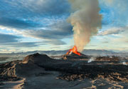
The archipelago of Indonesia consists of more than 13,000 islands, spread over an area that is similar in size to that of the continental United States. It is the country with the greatest number and density of active volcanoes.
Most volcanoes in Indonesia belong to the Sunda Volcanic Arc, streching over 3,000 kilometers from NW Sumatra to the Banda Sea. This volcanic arc results from the subduction of Indian Ocean crust beneath the Asian Plate and includes 76% of the region's volcanoes. To the NNW, the basaltic volcanism of the Andaman Islands results from short spreading centers, and to the east the Banda Arc reflects Pacific Ocean crust subducted westward. North of this arc, the tectonic setting is much more complex: several fragments of plates are converging to form multiple subduction zones, mainly oriented N-S. These produce the Sulawesi-Sangihe volcanoes on the west and Haimahera on the east of the collision zone.
Indonesia leads the world in many volcano statistics. It has the largest number of historically active volcanoes (76), its total of 1,171 dated eruptions is only narrowly exceeded by Japan's 1,274, although not much is know about the volcanic activity in the time before European colonialists arrived from the 15th century on. Indonesia has suffered the highest numbers of eruptions producing fatalities, damage to arable land, mudflows, tsunamis, domes, and pyroclastic flows. Four-fifths of Indonesian volcanoes with dated eruptions have erupted in this century.
Two of the most devastating volcanic eruptinos in historic time took place in Indonesia: the enormous eruption of Tambora in 1815,- the largest known eruption of the world during historical times,- had such far-reaching effects on the climate that for instance Europe was to experience 1816 as the year without summer. In 1883, the disastrous eruption of Krakatau carved itself deeply into the collective memory of mankind. The eruption of Krakatau was followed by severe tsunamis that killed about 30-40,000 people.
In 1920, a volcano survey was established by the Dutch-led government, leading to much improved volcano monitoring and reporting. The Volcanological Survey of Indonesia (VSI) now operates a network of 64 volcano observatories continuously monitoring 59 volcanoes.
---
Freely adapted from: Simkin and Siebert, 1994, Volcanoes of the World: Smithsonian Institution and Geoscience Press, Inc., Tucson, Arizona, 349p.