Contact | RSS | EN | DE | EL | ES | FR | IT | RU

Volcanoes of Guatemala

Acatenango | Agua | Almolonga | Atitlán | Ayarza | Barahona | Cerro Alutate | Cerro Ananopa | Cerro Redondo | Cerro Santiago | Chiquimula Volcanic Field | Cuilapa-Barbarena | Cuxliquel | Fuego | Guistepeque Volcanic Field | Ipala | Ixhuatan | Ixtepeque | Jumay Volcanic Field | Jumaytepeque | Moyuta | Pacaya | Piedra Grande | Pueblo Nuevo Viñas | Quezaltepeque | San Pedro | Santiaguito | Santo Tomas | Siete Orejas | Suchitán | Tacana | Tahual | Tajumulco | Tecuamburro | Tolimán
[menor] [más grande]

Volcano list

Acatenango

(Stratovolcano 3976 m / 13,044 ft)
[más info]

Agua

(Stratovolcano 3760 m / 12,336 ft)
[más info]

Almolonga

(Stratovolcano 3197 m / 10,489 ft)
[más info]

Atitlán

(Stratovolcano 3535 m / 11,598 ft)
[más info]

Ayarza

(Caldera(s) 1409 m / 4623 ft)
[más info]

Barahona

(Caldera(s) 2282 m / 7487 ft)
[más info]

Cerro Alutate

(Stratovolcano 2116 m / 6942 ft)
[más info]

Cerro Ananopa

(Volcanic field 386 m / 1266 ft)
[más info]

Cerro Redondo

(Shield(s) 768 m / 2520 ft)
[más info]

Cerro Santiago

(Volcanic field 1192 m / 3,911 ft)
[más info]

Chiquimula Volcanic Field

(Cinder cones 1192 m / 3,911 ft)
[más info]

Cuilapa-Barbarena

(Volcanic field 1454 m / 4,770 ft)
[más info]

Cuxliquel

(Lava dome(s) 3029 m / 9938 ft)
[más info]

Fuego

(Stratovolcano 3,763 m / 12,346 ft)
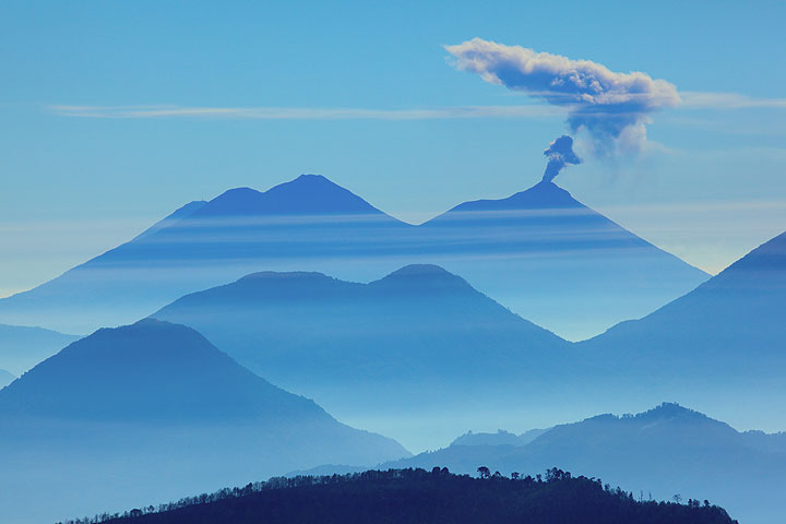
An ash eruption from Fuego volcano seen from the distance
Fuego, one of Central America's most active volcanoes, is one of three large stratovolcanoes overlooking Guatemala's former capital, Antigua. It typically has strombolian activity and sometimes phases of intense lava fountaining, producing tall ash plumes and dangerous pyroclasti... [más info]

Guistepeque Volcanic Field

(Pyroclastic cone(s) 1358 m / 4455 ft)
[más info]

Ipala

(Stratovolcano 1650 m / 5,413 ft)
[más info]

Ixhuatan

(Complex 1675 m / 5495 ft)
[más info]

Ixtepeque

(Lava domes 1292 m / 4,239 ft)
[más info]

Jumay Volcanic Field

(Stratovolcano 2174 m / 7133 ft)
[más info]

Jumaytepeque

(Stratovolcano 1815 m / 5,955 ft)
[más info]

Moyuta

(Stratovolcano 1662 m / 5,453 ft)
[más info]

Pacaya

(Complex volcano 2552 m (8,373 ft))
Pacaya volcano near Guatemala City is one of Guatemala's most active volcanoes, and its frequent eruptions are often visible from Guatemala City. Typical activity in recent years includes strombolian activity, lava flow emission and intermittend violent phases of lava fountaining... [más info]

Piedra Grande

(Stratovolcano(es) 1640 m / 5381 ft)
[más info]

Pueblo Nuevo Viñas

(Stratovolcano 1939 m / 6362 ft)
[más info]

Quezaltepeque

(Volcanic field 1200 m / 3,937 ft)
[más info]

San Pedro

(Stratovolcano 3020 m / 9908 ft)
[más info]

Santiaguito

(Stratovolcano 3772 m (12,375 ft))
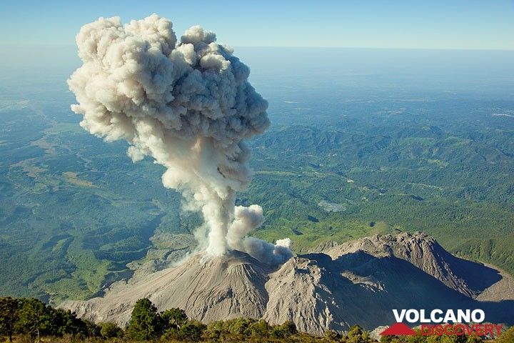
The lava dome complex of Santiaguito volcano seen from Santa Maria's summit
Santiaguito is the name of the dome complex that grew inside the collapse scar left by the catastrophic eruption and partial collapse of Santa María stratovolcano in 1902. Its currently active dome is called Caliente (the "hot one").
Symmetrical, forest-covered Santa María ... [más info]

Santo Tomas

(Stratovolcano(es) 3542 m / 11621 ft)
[más info]

Siete Orejas

(Stratovolcano 3370 m / 11056 ft)
[más info]

Suchitán

(Stratovolcanoes 2042 m / 6,699 ft)
[más info]

Tacana

(stratovolcano 4060 m / 13,320 ft)
Tacaná volcano on the Mexican-Guatemalan border is a symmetrical stratovolcano rising 1800 m above its base and forms the NW end of the Central American Volcanic Belt.
Tacana consists of overlapping volcanic edifices, reflecting a migration of vents from the NE to the SW o... [más info]

Tahual

(Stratovolcano 1716 m / 5,630 ft)
[más info]

Tajumulco

(Stratovolcano 4220 m / 13,845 ft)
[más info]

Tecuamburro

(Stratovolcano 1845 m / 6,053 ft)
[más info]

Tolimán

(Stratovolcano 3158 m / 10,361 ft)
[más info]
Geodynamic setting of Central Americal and active volcanoes
Latest news:
Try our free app!
Volcanoes & Earthquakes - new app for Android
Android | iOS version

Más en VolcanoDiscovery

Why is there advertising on this site?

Support us - Help us upgrade our services!

We truly love working to bring you the latest volcano and earthquake data from around the world. Maintaining our website and our free apps does require, however, considerable time and resources.
We need financing to increase hard- and software capacity as well as support our editor team. We're aiming to achieve uninterrupted service wherever an earthquake or volcano eruption unfolds, and your donations can make it happen! Every donation will be highly appreciated. If you find the information useful and would like to support our team in integrating further features, write great content, and in upgrading our soft- and hardware, please make a donation (PayPal or Online credit card payment).

Planned features:Thanks to your past donations, these features have been added recently:
Download and Upgrade the Volcanoes & Earthquakes app to get one of the fastest seismic and volcano alerts online:
Android | IOS
Thank you!
Sources: VolcanoDiscovery / VolcanoAdventures and other sources as noted.
Use of material: Most text and images on our websites are owned by us. Re-use is generally not permitted without authorization. Contact us for licensing rights.
Volcanoes & Earthquakes
VolcanoDiscovery Home
Volcanes | Sismos | Fotos | News | App
Adventure & Study Travel
Tours to Volcanoes and Volcanic Areas: walking tours, photo tours, study tours
Tours & Dates | FAQ | About us
Get our newsletter!
Company info
Contact | Legal info | Terms & conditions
Follow us
Follow us on facebook Follow us on Instagram Follow us on Twitter Visit our Youtube channel
EN | DE | EL | ES | FR | IT | RU
VolcanoDiscovery GmbH, Germany, Reg. nr.: HRB 103744, EU Tax Id: DE 297 465 123 owned and created by
Dr. Tom Pfeiffer, volcanologist, volcano photographer, tour organizer member of
IAVCEI
IAVCEI
Vulkanologische Gesellschaft
Volcanological Society
Ecotourism Greece
Ecotourism Greece
RUV insurance
Insured by R+V
VolcanoDiscovery © 2004- All Rights Reserved | Privacy - Cookie Settings