| RSS | EN | DE | EL | ES | FR | IT | RU

Turrialba Vulkan

Updated: 22. Apr. 2025 14:30 GMT -
Stratovolcano
Costa Rica, 10.03°N / -83.77°W
Summit height: 3340 m (10,958 ft)
Aktueller Status: normal / ruhend (1 von 5)
Last update: 19 Mär 2025 (Smithsonian / USGS Weekly Volcanic Activity Report)
Turrialba volcano seen from Irazu

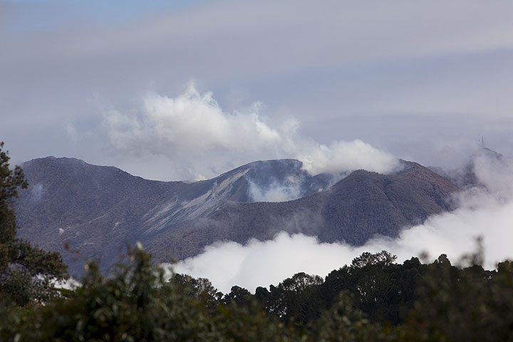
Turrialba (3340 m) is the easternmost of Costa Rica's active volcanoes. It is a large stratovolcano with a complex of 3 summit craters and its flanks mostly covered by farmland and forest. vegetation. After its previous eruption in 1866, signs of unrest started in 2006 and new phreatic activity began on Jan 4, 2010.

[smaller] [larger]
Typische Aktivität: Explosive.
Ausbrüche des Turrialba: 1723(?), 1847(?), 1853, 1855, 1861(?), 1864-65, 1866, 2010 (Jan 4) - ongoing

Letzte Erdbeben in der Nähe

Datum und UhrzeitMag / TiefeDistanz / Ort
13. Apr. 22:24 (GMT -6)
2?

99 km
23 km südwestlich Cartago, 13 km östlich von San Jose, San José, Costa Rica (unbestätigt) Info
13. Apr. 22:24 (Costa Rica)
3.5

75 km
26 km westlich 10 km östlich von San Jose, San José, Costa Rica Info
Sonntag, 13. April 2025 GMT (1 Beben)
13. Apr. 13:50 (Costa Rica)
4.0

11 km
11 km östlich Cartago, 46 km östlich von San Jose, San José, Costa Rica 9 BerichteInfo
Freitag, 11. April 2025 GMT (3 Beben)
11. Apr. 12:34 (GMT -6)
2.4

9 km
20 km westlich 21 km nordöstlich von San Jose, San José, Costa Rica Info
11. Apr. 06:34 (Weltzeit)
2?

23 km
24 km westlich 17 km nordöstlich von San Jose, San José, Costa Rica (unbestätigt) Info
11. Apr. 01:02 (Weltzeit)
2?

1 km
5.8 km südöstlich Cartago, 40 km östlich von San Jose, San José, Costa Rica (unbestätigt) Info

Beschreibung

Turrialba is the easternmost of Costa Rica's active volcanoes and a large vegetated basaltic-to-dacitic stratovolcano. It is located opposite Irazú volcano, both being separated by a broad saddle.
Together with Irazú, Turrialba is one of Costa Rica's largest volcanoes. During the past 3500 years in prehistoric times, it has had at least 5 larger explosive eruptions. The top of Turrialba has 3 craters at the upper SW end of a broad 800 x 2200 m wide summit depression breached to the NE.
Eruptions from Turrialba occurred mostly from the summit craters, although two flank cones are found on the SW flank. During the 19th century, a few eruptions occurred that produced pyroclastic flows. Since an eruption in 1866 and until 2006, Turrialba was quiescent, but showed strong fumarolic activity at the central craters.
Since 2006, increased fumarolic and seismic activity were noted. On Jan 4, 2010, two new vents that later merged into a fissure aligned along the tectonic trend of the summit area opened in its western crater and started to erupt large amounts of sulphur dioxide gas and occasional lithic ash. This phreatic activity was accompanied by strong tremors and continued for a few days, but declined since Jan 8. Ash fall in the surroundings of the volcano and acid rain caused damage to agriculture and prompted evacuation of about 30 inhabitants living in the immediate vicinity of the volcano.

Bedeutende Vulkanausbrüche: Turrialba volcano

In the past 10,000 years, Turrialba has had at least 21 confirmed volcanic eruptions, out of which 14 are documented by historical records, while the others can be inferred from geological evidence.
Additionally, there are 4 uncertain or discredited eruptions from Turrialba volcano.
The table below lists all known eruptions (date in bold face) of Turrialba volcano in historic times and during the past 10,000 years. Updates on the most recent volcanic activity of Turrialba can be found on the news page of Turrialba volcano.
DatumHinweisVEITodesopferSchaden
2022 Jul 17
Hist. dokumentiert
1
unbekannt
2021 Nov 3 - 2022 Feb 28
Hist. dokumentiert
1
unbekannt
2021 Jun 13 - Jul 23
Hist. dokumentiert
1
unbekannt
2020 Jun 18 - Aug 24
Hist. dokumentiert
1
unbekannt
2015 Mär 8 - 2019 Dez 7Cráter Central, Cráter Oeste
Hist. dokumentiert
3
unbekannt
2014 Okt 29 - Dez 8West Crater
Hist. dokumentiert
2
unbekannt
2013 Mai 21 - Jun 4West Crater
Hist. dokumentiert
1
unbekannt
2012 Jan 12 - Jan 18West Crater (SE flank)
Hist. dokumentiert
2
unbekannt
2011 Jan 14West Crater
Hist. dokumentiert
1
unbekannt
?? 2010 Jul 24 - Aug 15
Unsicherer Ausbruch
Hist. dokumentiert
2
unbekannt
2010 Jan 5 - Mär 7 ?SW crater
Hist. dokumentiert
2
unbekannt
1866 Jan - Mai 8Central and SW summit craters
Hist. dokumentiert
3
unbekannt
1864 Aug 17 - 1865 MärCentral and SW summit craters
Hist. dokumentiert
2
unbekannt
?? 1861
Unsicherer Ausbruch
?
unbekannt
1855 Mai
Hist. dokumentiert
2
unbekannt
1853
Hist. dokumentiert
2
unbekannt
?? 1847
Unsicherer Ausbruch
?
unbekannt
?? 1723
Unsicherer Ausbruch
1
unbekannt
1350 ? AD?
unbekannt
640 ±40 y. AD?
unbekannt
40 ±50 y. ADCentral summit crater4
unbekannt
Anmerkung:
Unsere Liste von Vulkanausbrüchen orientiert sich eng an der Datenbank des Global Volcanism Project (GVP) des Smithsonian Instituts, der international anerkanntesten globalen Datenquelle für Vulkanausbrüche. Sie schließt aber auch bedeutende Eruptionsepisoden oder damit zusammenhängende Vulkanereignisse ein. Unter "Vulkanausbrüchen" versteht man in der Regel meist Serien einzelner Eruptionsepisoden, die zeitlich aufeinander folgen oder sich (bei mehreren beteiligten Ausbruchspunkten an einem Vulkan) auch überlappen können und unter Umständen viele Jahre, Jahrzehnte oder noch länger andauern können. So ist z.B. die aktuelle Tätigkeit des Stromboli als ein einziger Ausbruch verstanden, der seit 1934 anhält.
Quellen: NOAA National Centers for Environmental Information (NCEI), Global Significant Volcanic Eruptions Database. doi:10.7289/V5TD9V7K | Global Volcanism Project / Smithsonian Institution

Turrialba Volcano FAQ

+When was the last eruption of Turrialba volcano?

+How often does Turrialba volcano erupt?

+How active is Turrialba volcano at present?

+When was the largest eruption of Turrialba volcano?

Neueste Satellitenbilder

Turrialba Satellitenbild sat1Turrialba Satellitenbild sat2

Turrialba Vulkan Karten

Below is a selection of maps showing the location and surroundings of the volcano at various resolutions based on aerial-imagery / terrain maps. Feel free to use them for non-commercial purposes on your blog or website as long as you credit them with a link back to this page (click to copy it).
Satellite/aerial-type map of Turrialba volcano (world scale)
Terrain-type map of Turrialba volcano (world scale)
Satellite/aerial-type map of Turrialba volcano (region scale large)
Terrain-type map of Turrialba volcano (region scale large)
Satellite/aerial-type map of Turrialba volcano (region scale medium)
Terrain-type map of Turrialba volcano (region scale medium)
Satellite/aerial-type map of Turrialba volcano (region scale small)
Terrain-type map of Turrialba volcano (region scale small)
Satellite/aerial-type map of Turrialba volcano (local scale large)
Terrain-type map of Turrialba volcano (local scale large)
Satellite/aerial-type map of Turrialba volcano (local scale medium)
Terrain-type map of Turrialba volcano (local scale medium)
Satellite/aerial-type map of Turrialba volcano (local scale small)
Terrain-type map of Turrialba volcano (local scale small)
Satellite/aerial-type map of Turrialba volcano (scale of 10s of km)
Terrain-type map of Turrialba volcano (scale of 10s of km)
Satellite/aerial-type map of Turrialba volcano (scale of 20-40 km)
Terrain-type map of Turrialba volcano (scale of 20-40 km)
Satellite/aerial-type map of Turrialba volcano (scale of approx. 10-20 km)
Terrain-type map of Turrialba volcano (scale of approx. 10-20 km)
Satellite/aerial-type map of Turrialba volcano (scale of 5-10 km)
Satellite/aerial-type map of Turrialba volcano (scale of few kilometers)
Volcanoes & Earthquakes - new app for Android
Garantierte Reisen
9.-25. Jun 2025: Volcanoes and Spices - N-Sulawesi + Halmahera (Indonesien)
7.-23. Jul 2025: Volcanoes and Spices - N-Sulawesi + Halmahera (Indonesien)
1.-17. Aug 2025: Volcanoes and Spices - N-Sulawesi + Halmahera (Indonesien)
1.-14. Okt 2025: Wüste, Salz und Vulkane - Danakilwüste (Äthiopien)
4.-12. Okt 2025: Feuerberge Siziliens - vom Stromboli zum Ätna - Äolische Inseln + Ätna
3.-19. Nov 2025: Volcanoes and Spices - N-Sulawesi + Halmahera (Indonesien)
= Plätze frei   = garantiert   = Wenig freie Plätze   = Ausgebucht
Mi, 19. Mär 2025, 15:00

Turrialba volcano (Costa Rica) - Smithsonian / USGS Weekly Volcanic Activity Report for 12 March-18 March 2025 (New Activity / Unrest)

The Observatorio Vulcanológico y Sismológico de Costa Rica-Universidad Nacional (OVSICORI-UNA) reported that a small landslide in Turrialba's West Crater produced a small ash plume at 1545 on 14 March. ... Alles lesen
Mi, 12. Mär 2025, 15:00

Turrialba volcano (Costa Rica) - Smithsonian / USGS Weekly Volcanic Activity Report for 5 March-11 March 2025 (New Activity / Unrest)

The Observatorio Vulcanológico y Sismológico de Costa Rica-Universidad Nacional (OVSICORI-UNA) reported that the seismic network at Turrialba recorded signals during 9-10 March that were likely related to small landslides of material within West Crater. Gas emissions remained at low levels. ... Alles lesen

Auf dieser Seite:

Try our free app!
Volcanoes & Earthquakes - new app for Android
Android | iOS version

More on VolcanoDiscovery

Warum gibt es Werbung auf dieser Seite?

Unterstützen Sie unsere Arbeit!

Diese Webseite und die dazugehörigen Apps und Tools instandzuhalten und kostenlos Nachrichten zu Vulkanen, Erdbeben und anderen Themen bereitzustellen, verschlingt enorm viel Zeit und auch Geld.
Wenn Sie die Infos mögen und uns in der Arbeit dazu unterstützen wollen, würden wir uns über eine Spende (über PayPal) sehr freuen.
Online Zahlung (Kreditkarte)
Damit können wir Ihnen auch in Zukunft neue Features entwickeln und Bestehende laufend verbessern.Vielen Dank!
Sources: VolcanoDiscovery / VolcanoAdventures and other sources as noted.
Use of material: Most text and images on our websites are owned by us. Re-use is generally not permitted without authorization. Contact us for licensing rights.
Volcanoes & Earthquakes
VolcanoDiscovery Home
Vulkane | Erdbeben | Fotos | News | | Shop | App
Adventure & Study Travel
Reisen zu Vulkanen und Vulkangebieten: Wanderreisen, Studienreisen, Fotoreisen
Tours & Dates | FAQ | About us
Get our newsletter!
Company info
Kontakt | Impressum | AGB
Follow us
Follow us on facebook Follow us on Instagram Follow us on Bluesky Follow us on Twitter Visit our Youtube channel
EN | DE | EL | ES | FR | IT | RU
VolcanoDiscovery GmbH, Germany, Reg. nr.: HRB 103744, EU Tax Id: DE 297 465 123 owned and created by
Dr. Tom Pfeiffer, volcanologist, volcano photographer, tour organizer member of
IAVCEI
IAVCEI
Vulkanologische Gesellschaft
Volcanological Society
Ecotourism Greece
Ecotourism Greece
RUV insurance
Insured by R+V
VolcanoDiscovery © 2004- All Rights Reserved | Datenschutz - Cookie Einstellungen