Tajumulco Vulkan
Updated: 13. Mär. 2025 21:19 GMT -
Stratovolcano
Guatemala, 15.03°N / -91.9°W 
Summit height: 4220 m / 13,845 ft
Aktueller Status: normal / ruhend (1 von 5)
[smaller] [larger]
Ausbrüche des Tajumulco: unknown, no recent eruptions
Letzte Erdbeben in der Nähe
| Datum und Uhrzeit | Mag / Tiefe | Distanz / Ort | |||
|---|---|---|---|---|---|
Beschreibung
Tajumulco is Guatemala's highest peak and the highest volcano in Central America. Two summits, one with a 50-70 m wide crater, lie along a NW-SE line. A lava flow from the 4220-m-high NW summit traveled down a deep valley on the NW flank. The andesitic-dacitic volcano was constructed over the NW end of a large arcuate SW-facing escarpment of uncertain origin. Tajumulco has had several unconfirmed reports of historical eruptions. Sapper (1917) considered Tajumulco to have erupted during historical time, but without accurate dates. The volcano was reported to eject many rocks, destroying houses on October 24, 1765, but this may have been a rock avalanche. Juarros reported some eruptions before 1808, and there are unlikely reports of eruptions in 1821 (or 1822), 1863, and 1893 (Incer 1988, unpublished manuscript).---
Smithsonian / GVP volcano information
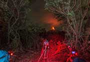
Tajumulco Volcano Photos
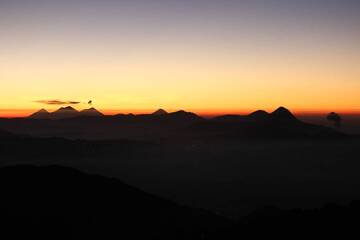
10. Fernsicht auf die Vulkane vom Gipfel des Vulkans Tajumulco 4220 m bei Sonnenaufgang – von rechts nach links – Santaguito (ausbrechend), Santa Maria, Santo Tomas, Zuni...
Bedeutende Vulkanausbrüche: Tajumulco volcano
In the past 10,000 years, Tajumulco has had only one confirmed historic eruption ###WHEN1###|only one confirmed historic eruption ###WHEN1### and one ###WHEN2### inferred from geological evidence|only one confirmed historic eruption ###WHEN1###, but at least ###NUM_INFERRED### eruptions can be inferred from geological evidence|at least ###NUM_CONFIRMED### confirmed eruptions, all documented by historical records or observations|at least ###NUM_CONFIRMED### confirmed volcanic eruptions, out of which ###NUM_HISTORIC### are documented by historical records, while the others can be inferred from geological evidence.
No historic eruptions are known from Tajumulco volcano, but at least one eruption ###WHEN2### can be inferred from geological evidence|evidence from at least ###NUM_CONFIRMED### eruptions during the past 10,000 years can be found in the geological record.
There are only 2 uncertain or discredited eruptions from Tajumulco volcano during the past 10,000 years.
The table below lists all known eruptions (date in bold face) of Tajumulco volcano in historic times and during the past 10,000 years. Updates on the most recent volcanic activity of Tajumulco can be found on the news page of Tajumulco volcano.
| Datum | Hinweis | VEI | Todesopfer | Schaden | |
|---|---|---|---|---|---|
?? | Unsicherer Ausbruch | 2 | unbekannt | ||
?? | Unsicherer Ausbruch | 2 | unbekannt | ||
Anmerkung:
Unsere Liste von Vulkanausbrüchen orientiert sich eng an der Datenbank des Global Volcanism Project (GVP) des Smithsonian Instituts, der international anerkanntesten globalen Datenquelle für Vulkanausbrüche. Sie schließt aber auch bedeutende Eruptionsepisoden oder damit zusammenhängende Vulkanereignisse ein. Unter "Vulkanausbrüchen" versteht man in der Regel meist Serien einzelner Eruptionsepisoden, die zeitlich aufeinander folgen oder sich (bei mehreren beteiligten Ausbruchspunkten an einem Vulkan) auch überlappen können und unter Umständen viele Jahre, Jahrzehnte oder noch länger andauern können. So ist z.B. die aktuelle Tätigkeit des Stromboli als ein einziger Ausbruch verstanden, der seit 1934 anhält.
Quellen: NOAA National Centers for Environmental Information (NCEI), Global Significant Volcanic Eruptions Database. doi:10.7289/V5TD9V7K | Global Volcanism Project / Smithsonian Institution
Neueste Satellitenbilder

Tajumulco Vulkan Karten
Below is a selection of maps showing the location and surroundings of the volcano at various resolutions based on aerial-imagery / terrain maps. Feel free to use them for non-commercial purposes on your blog or website as long as you credit them with a link back to this page (click to copy it).

Satellite/aerial-type map of Tajumulco volcano (world scale)

Terrain-type map of Tajumulco volcano (world scale)

Satellite/aerial-type map of Tajumulco volcano (region scale large)

Terrain-type map of Tajumulco volcano (region scale large)

Satellite/aerial-type map of Tajumulco volcano (region scale medium)

Terrain-type map of Tajumulco volcano (region scale medium)

Satellite/aerial-type map of Tajumulco volcano (region scale small)

Terrain-type map of Tajumulco volcano (region scale small)

Satellite/aerial-type map of Tajumulco volcano (local scale large)

Terrain-type map of Tajumulco volcano (local scale large)

Satellite/aerial-type map of Tajumulco volcano (local scale medium)

Terrain-type map of Tajumulco volcano (local scale medium)

Satellite/aerial-type map of Tajumulco volcano (local scale small)

Terrain-type map of Tajumulco volcano (local scale small)

Satellite/aerial-type map of Tajumulco volcano (scale of 10s of km)

Terrain-type map of Tajumulco volcano (scale of 10s of km)

Satellite/aerial-type map of Tajumulco volcano (scale of 20-40 km)

Terrain-type map of Tajumulco volcano (scale of 20-40 km)

Satellite/aerial-type map of Tajumulco volcano (scale of approx. 10-20 km)

Terrain-type map of Tajumulco volcano (scale of approx. 10-20 km)

Satellite/aerial-type map of Tajumulco volcano (scale of 5-10 km)

Satellite/aerial-type map of Tajumulco volcano (scale of few kilometers)