| RSS | EN | DE | EL | ES | FR | IT | RU

Poas Vulkan

Updated: 22. Apr. 2025 18:53 GMT -
Stratovolcano
Costa Rica, 10.2°N / -84.23°W
Summit height: 2708 m (8,884 ft)
Aktueller Status: Ausbruch (4 von 5)
Last update: 22 Apr 2025 (Volcanic Ash Advisory)

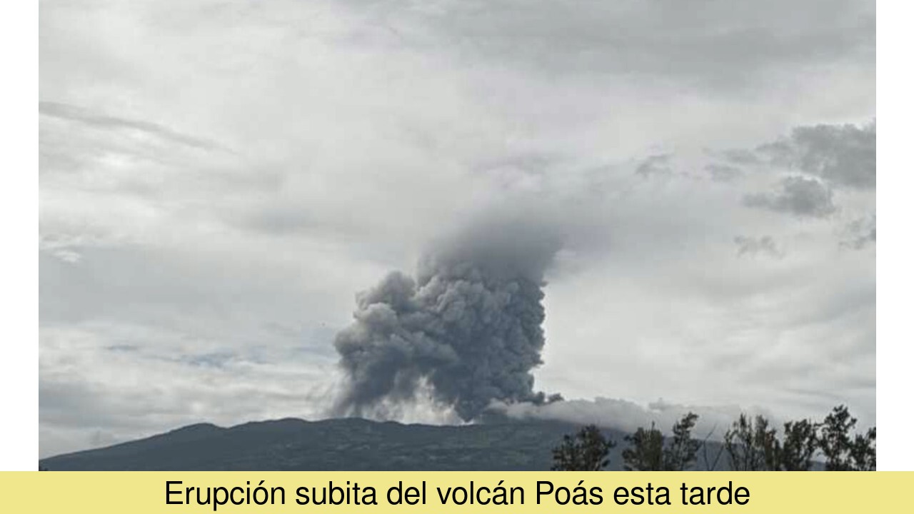
Poás is one of Costa Rica´s most active volcanoes, and one of its most frequently visited and prominent ones. It contains a green acid crater lake and during some of its frequent phreatic eruptions, water from the lake is ejected like a geyser.

[smaller] [larger]
Typische Aktivität: Phreatic eruptions, sometimes geyser-like ejections of water from the acid crater lake.
Ausbrüche des Poas: 1828, 1834, 1838(?), 1860, 1879(?), 1880, 1888-91, 1895, 1898-1907, 1910, 1910, 1914, 1914-15, 1925, 1929, 1941-46, 1948-51, 1952-57, 1958-61, 1963, 1964-65, 1967, 1969, 1970, 1972-73, 1974-75, 1976, 1977, 1977-78, 1978, 1979-80, 1980, 1981, 1987-90, 1991, 1992, 1992-93, 1994, 1996, 2010, 2011, 2012, 2013, 2014, 2016, 2017, 2025

Letzte Erdbeben in der Nähe

Datum und UhrzeitMag / TiefeDistanz / Ort
18. Apr. 21:19 (GMT -6)
3.1

9 km
14 km nordöstlich 37 km nördlich von San Jose, San José, Costa RicaI FELT IT Info
Mittwoch, 9. April 2025 GMT (2 Beben)
9. Apr. 22:27 (Weltzeit)
2?

1 km
1.4 km südlich 19 km nördlich von Alajuela, Provinz Alajuela, Costa Rica (unbestätigt) Info
9. Apr. 21:35 (Weltzeit)
2?

1 km
4.1 km südlich Provinz Alajuela, 30 km nordwestlich von San Jose, San José, Costa Rica (unbestätigt) Info

Beschreibung

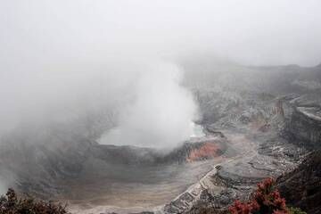
The broad, well-vegetated edifice of Poás has three craters in a N-S line. The 2708-m-high basaltic-to-dacitic complex stratovolcano is cut by a N-S-trending fissure that extends to the lower northern flank, where a parasite volcano (the Congo stratovolcano) and several explosion craters, or maars, most of them lake-filled, have been created.
Poás has two summit crater lakes. The southermost one, Botos, is cold, clear has not eruptied for about 7500 years. The other crater lake is geothermally heated and -after Kawah Ijen in Indonesia - is probably the world's second most acidic natural lake. Its pH is near zero.
---
Source: GVP, Smithsonian Institution
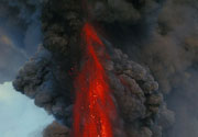
Poas Volcano Photos

Bedeutende Vulkanausbrüche: Poas volcano

In the past 10,000 years, Poas has had at least 61 confirmed volcanic eruptions, out of which 54 are documented by historical records, while the others can be inferred from geological evidence.
Additionally, there are 2 uncertain or discredited eruptions from Poas volcano.
The table below lists all known eruptions (date in bold face) of Poas volcano since around 1900. Updates on the most recent volcanic activity of Poas can be found on the news page of Poas volcano.
DatumHinweisVEITodesopferSchaden
2023 Dez 1 - 2024 Mai 5
Hist. dokumentiert
1
unbekannt
2023 Aug 2 - Aug 11
Hist. dokumentiert
1
unbekannt
2022 Apr 6Crater lake - Fumarola Naranja
Hist. dokumentiert
1
unbekannt
2019 Feb 7 - Sep 30
Hist. dokumentiert
2
unbekannt
2017 Apr 12 - Nov 6Laguna Caliente Crater
Hist. dokumentiert
1
unbekannt
2016 Jun 5 - Aug 16Lake in summit crater
Hist. dokumentiert
1
unbekannt
2009 Nov 16 ±15 d. - 2014 Okt 13
Hist. dokumentiert
1
unbekannt
2009 Jan 12 - Mär 21 ?
Hist. dokumentiert
1
unbekannt
2008 Jan 13
Hist. dokumentiert
1
unbekannt
2006 Sep 25 - Dez 16
Hist. dokumentiert
1
unbekannt
2006 Mär 24
Hist. dokumentiert
1
unbekannt
1996 Apr 8
Hist. dokumentiert
1
unbekannt
1994 Mär 16 ±15 d. - Okt 16 ±15 d.
Hist. dokumentiert
2
unbekannt
1992 Okt 16 ±15 d. - 1993 Sep 16 ±15 d.
Hist. dokumentiert
0
unbekannt
1992 Feb 16 ±15 d. - Mär 16 ±15 d.
Hist. dokumentiert
1
unbekannt
1991 Mär 6 - Sep 16 ±15 d.
Hist. dokumentiert
1
unbekannt
1987 Jun 16 ±15 d. - 1990 Jun 16 ±15 d.
Hist. dokumentiert
2
unbekannt
1981 Mär 16 ±15 d. - Mai 16 ±15 d.
Hist. dokumentiert
1
unbekannt
1980 Dez 26
Hist. dokumentiert
1
unbekannt
1980 Sep 12
Hist. dokumentiert
1
unbekannt
1979 Sep 8 - 1980 Jan 16 ±15 d.
Hist. dokumentiert
1
unbekannt
1978 Sep 22 - Dez 16 ±15 d.
Hist. dokumentiert
1
unbekannt
1977 Dez 18 - 1978 Jun 15
Hist. dokumentiert
2
unbekannt
1977 Mai 16 ±15 d. - Jul 16 ±15 d.
Hist. dokumentiert
1
unbekannt
1976 Jun 21 - Nov 16 ±15 d.
Hist. dokumentiert
2
unbekannt
1974 Sep 11 - 1975 Feb 16 ±15 d.
Hist. dokumentiert
2
unbekannt
1972 Feb 9 - 1973 Sep 8
Hist. dokumentiert
2
unbekannt
1970 Jul 16 ±15 d.
Hist. dokumentiert
1
unbekannt
1969 Mai 3 - Jun 3
Hist. dokumentiert
2
unbekannt
1968 Jul 2 ±182 d.
Hist. dokumentiert
1
unbekannt
1967 Jan 1
Hist. dokumentiert
1
unbekannt
1964 Dez 25 - 1965 Mär 16 ±15 d.
Hist. dokumentiert
2
unbekannt
1963 Mai 23 - Jul 2
Hist. dokumentiert
2
unbekannt
1958 Jul 2 ±182 d. - 1961 Jul 3 ?
Hist. dokumentiert
2
unbekannt
1952 Mär 23 - 1957 Dez 25
Hist. dokumentiert
2
unbekannt
1948 - 1951 Jul 2 ±182 d.
Hist. dokumentiert
1
unbekannt
1946 Nov 4 ±4 d.
Hist. dokumentiert
1
unbekannt
1941 - 1946
Hist. dokumentiert
1
unbekannt
1932 - 1934
Hist. dokumentiert
1?
unbekannt
1929
Hist. dokumentiert
1
unbekannt
1925
Hist. dokumentiert
1
unbekannt
1916
Hist. dokumentiert
2
unbekannt
1914 Okt 8 - 1915 Mai 15 oder danach
Hist. dokumentiert
2
unbekannt
1914 Mai 30
Hist. dokumentiert
2
unbekannt
1910 Sep 12 - Okt 14
Hist. dokumentiert
1
unbekannt
1910 Jan 25 - Feb
Hist. dokumentiert
2
unbekannt
1898 Dez 29 - 1907 Dez 31 ±365 d.
Hist. dokumentiert
1
unbekannt
Anmerkung:
Unsere Liste von Vulkanausbrüchen orientiert sich eng an der Datenbank des Global Volcanism Project (GVP) des Smithsonian Instituts, der international anerkanntesten globalen Datenquelle für Vulkanausbrüche. Sie schließt aber auch bedeutende Eruptionsepisoden oder damit zusammenhängende Vulkanereignisse ein. Unter "Vulkanausbrüchen" versteht man in der Regel meist Serien einzelner Eruptionsepisoden, die zeitlich aufeinander folgen oder sich (bei mehreren beteiligten Ausbruchspunkten an einem Vulkan) auch überlappen können und unter Umständen viele Jahre, Jahrzehnte oder noch länger andauern können. So ist z.B. die aktuelle Tätigkeit des Stromboli als ein einziger Ausbruch verstanden, der seit 1934 anhält.
Quellen: NOAA National Centers for Environmental Information (NCEI), Global Significant Volcanic Eruptions Database. doi:10.7289/V5TD9V7K | Global Volcanism Project / Smithsonian Institution

Poas Volcano FAQ

+When was the last eruption of Poas volcano?

+How often does Poas volcano erupt?

+How active is Poas volcano at present?

+When was the largest eruption of Poas volcano?

Neueste Satellitenbilder
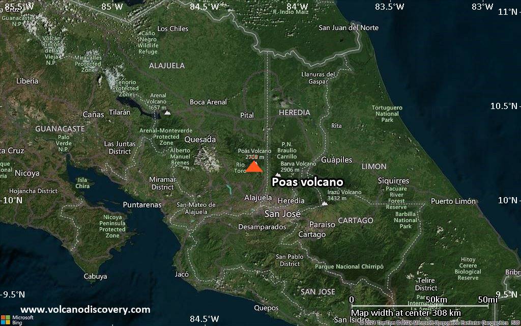
Poas Satellitenbild sat1Poas Satellitenbild sat2

Poas Vulkan Karten

Below is a selection of maps showing the location and surroundings of the volcano at various resolutions based on aerial-imagery / terrain maps. Feel free to use them for non-commercial purposes on your blog or website as long as you credit them with a link back to this page (click to copy it).
Satellite/aerial-type map of Poas volcano (world scale)
Terrain-type map of Poas volcano (world scale)
Satellite/aerial-type map of Poas volcano (region scale large)
Terrain-type map of Poas volcano (region scale large)
Satellite/aerial-type map of Poas volcano (region scale medium)
Terrain-type map of Poas volcano (region scale medium)
Satellite/aerial-type map of Poas volcano (region scale small)
Terrain-type map of Poas volcano (region scale small)
Satellite/aerial-type map of Poas volcano (local scale large)
Terrain-type map of Poas volcano (local scale large)
Satellite/aerial-type map of Poas volcano (local scale medium)
Terrain-type map of Poas volcano (local scale medium)
Satellite/aerial-type map of Poas volcano (local scale small)
Terrain-type map of Poas volcano (local scale small)
Satellite/aerial-type map of Poas volcano (scale of 10s of km)
Terrain-type map of Poas volcano (scale of 10s of km)
Satellite/aerial-type map of Poas volcano (scale of 20-40 km)
Terrain-type map of Poas volcano (scale of 20-40 km)
Satellite/aerial-type map of Poas volcano (scale of approx. 10-20 km)
Terrain-type map of Poas volcano (scale of approx. 10-20 km)
Satellite/aerial-type map of Poas volcano (scale of 5-10 km)
Satellite/aerial-type map of Poas volcano (scale of few kilometers)
Volcanoes & Earthquakes - new app for Android
Garantierte Reisen
9.-25. Jun 2025: Volcanoes and Spices - N-Sulawesi + Halmahera (Indonesien)
7.-23. Jul 2025: Volcanoes and Spices - N-Sulawesi + Halmahera (Indonesien)
1.-17. Aug 2025: Volcanoes and Spices - N-Sulawesi + Halmahera (Indonesien)
1.-14. Okt 2025: Wüste, Salz und Vulkane - Danakilwüste (Äthiopien)
4.-12. Okt 2025: Feuerberge Siziliens - vom Stromboli zum Ätna - Äolische Inseln + Ätna
3.-19. Nov 2025: Volcanoes and Spices - N-Sulawesi + Halmahera (Indonesien)
= Plätze frei   = garantiert   = Wenig freie Plätze   = Ausgebucht
Di, 22. Apr 2025, 08:22

Poás volcano (Costa Rica): near-continuous ash emissions

Eruption of Poás volcano yesterday afternoon (image: OVSICORI-UNA / facebook)
The volcano remains very active, producing near-constant emissions of ash plumes that have been rising to approx. 500-1,000 m above the crater, and creating plumes that have been drifting towards westerly directions at altitudes around 10,000 ft (3 km), as reported by numerous ash advisory warnings from VAAC Washington. ... Alles lesen

Auf dieser Seite:

Try our free app!
Volcanoes & Earthquakes - new app for Android
Android | iOS version

More on VolcanoDiscovery

Warum gibt es Werbung auf dieser Seite?

Unterstützen Sie unsere Arbeit!

Diese Webseite und die dazugehörigen Apps und Tools instandzuhalten und kostenlos Nachrichten zu Vulkanen, Erdbeben und anderen Themen bereitzustellen, verschlingt enorm viel Zeit und auch Geld.
Wenn Sie die Infos mögen und uns in der Arbeit dazu unterstützen wollen, würden wir uns über eine Spende (über PayPal) sehr freuen.
Online Zahlung (Kreditkarte)
Damit können wir Ihnen auch in Zukunft neue Features entwickeln und Bestehende laufend verbessern.Vielen Dank!
Sources: VolcanoDiscovery / VolcanoAdventures and other sources as noted.
Use of material: Most text and images on our websites are owned by us. Re-use is generally not permitted without authorization. Contact us for licensing rights.
Volcanoes & Earthquakes
VolcanoDiscovery Home
Vulkane | Erdbeben | Fotos | News | | Shop | App
Adventure & Study Travel
Reisen zu Vulkanen und Vulkangebieten: Wanderreisen, Studienreisen, Fotoreisen
Tours & Dates | FAQ | About us
Get our newsletter!
Company info
Kontakt | Impressum | AGB
Follow us
Follow us on facebook Follow us on Instagram Follow us on Bluesky Follow us on Twitter Visit our Youtube channel
EN | DE | EL | ES | FR | IT | RU
VolcanoDiscovery GmbH, Germany, Reg. nr.: HRB 103744, EU Tax Id: DE 297 465 123 owned and created by
Dr. Tom Pfeiffer, volcanologist, volcano photographer, tour organizer member of
IAVCEI
IAVCEI
Vulkanologische Gesellschaft
Volcanological Society
Ecotourism Greece
Ecotourism Greece
RUV insurance
Insured by R+V
VolcanoDiscovery © 2004- All Rights Reserved | Datenschutz - Cookie Einstellungen