| RSS | EN | DE | EL | ES | FR | IT | RU

Fuego Vulkan

Updated: 16. Apr. 2025 15:50 GMT -
Stratovolcano
Guatemala, 14.47°N / -90.88°W
Summit height: 3,763 m / 12,346 ft
Aktueller Status: Ausbruch (4 von 5)
Last update: 21 Mär 2025 (Volcanic Ash Advisory)
An ash eruption from Fuego volcano seen from the distance

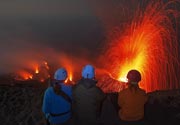
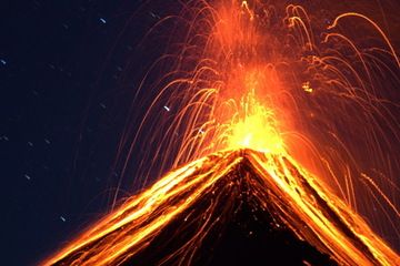
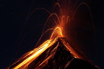
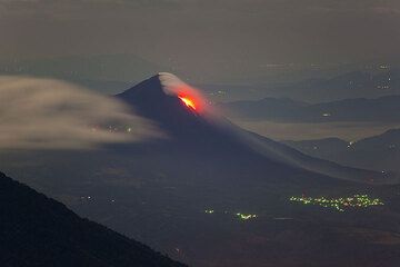
Fuego, one of Central America's most active volcanoes, is one of three large stratovolcanoes overlooking Guatemala's former capital, Antigua. It typically has strombolian activity and sometimes phases of intense lava fountaining, producing tall ash plumes and dangerous pyroclastic flows.

[smaller] [larger]
Typische Aktivität: Dominantly explosive, construction of lava domes and extrusion of viscous lava flows. In near constant activity, at least during the past centuries.
Ausbrüche des Fuego: 1581, 1585, 1586, 1587, 1614, 1617, 1620, 1623, 1629, 1679(?), 1685, 1686, 1689(?), 1699, 1702, 1705, 1706, 1709(?), 1710,1717,1730, 1732, 1737, 1751(?), 1765(?), 1773(?), 1799, 1826, 1829, 1850(?), 1852(?), 1855, 1856, 1857, 1860, 1861(?), 1867(?), 1880, 1896, 1932, 1944, 1949, 1953, 1955, 1957, 1962, 1963, 1966, 1967, 1971, 1973, 1974, 1975, 1977, 1987, 1999, 2002 - ongoing

Letzte Erdbeben in der Nähe

Datum und UhrzeitMag / TiefeDistanz / Ort

Beschreibung

Collapse of the ancestral Meseta volcano about 8,500 years ago produced a massive debris avalanche that traveled about 50 km onto the Pacific coastal plain. Growth of the modern Fuego volcano followed, continuing the southward migration of volcanism that began at Acatenango, the northern twin volcano of Fuego. Frequent vigorous historical eruptions have been recorded since 1524 and have produced major ashfalls, along with occasional pyroclastic flows and lava flows. The last major explosive eruption from Fuego took place in 1974, producing spectacular pyroclastic flows visible from Antigua.

Fuego Volcano Photos

Bedeutende Vulkanausbrüche: Fuego volcano

In the past 10,000 years, Fuego has had at least 61 confirmed volcanic eruptions, out of which 55 are documented by historical records, while the others can be inferred from geological evidence.
Additionally, there are 18 uncertain or discredited eruptions from Fuego volcano.
The table below lists all known eruptions (date in bold face) of Fuego volcano since around 1900. Updates on the most recent volcanic activity of Fuego can be found on the news page of Fuego volcano.
DatumHinweisVEITodesopferSchaden
2002 Jan 4 - anhaltend
Hist. dokumentiert
3
unbekannt
2018 Jun 3
(Ausbruch 2002 Jan 4 - anhaltend)
Hist. dokumentiert
2201
sehr schwer
Info
2017 Jun 6
(Ausbruch 2002 Jan 4 - anhaltend)
Hist. dokumentiert
2
mittel
Info
1999 Mai 21 - 2000 Dez 9 oder danach
Hist. dokumentiert
2
unbekannt
1999 Mai 21
(Ausbruch 1999 Mai 21 - 2000 Dez 9 oder danach)
Hist. dokumentiert
2
unbekannt
Info
1987 Jan 5 ±4 d. - Feb 16 ±15 d.
Hist. dokumentiert
1
unbekannt
1977 Sep 11 - 1979 Aug 8
Hist. dokumentiert
2
unbekannt
1977 Mär 3 - Apr 19
Hist. dokumentiert
1
unbekannt
1975 Mai 28 - Okt 21
Hist. dokumentiert
1
unbekannt
1974 Okt 10 - Dez 4
Hist. dokumentiert
4
unbekannt
1974 Okt 10
(Ausbruch 1974 Okt 10 - Dez 4)
Hist. dokumentiert
41-50 (*)
mittel
Info
1973 Feb 23 - Mär 23
Hist. dokumentiert
2
unbekannt
1971 Sep 14 - Sep 15
Hist. dokumentiert
3
unbekannt
1971 Sep 14
(Ausbruch 1971 Sep 14 - Sep 15)
Hist. dokumentiert
310
unbekannt
Info
1967 Apr 22 - Apr 24
Hist. dokumentiert
2
unbekannt
1966 Aug 12 - Aug 13
Hist. dokumentiert
3
unbekannt
1966 Feb 7 - Mai 1
Hist. dokumentiert
3
unbekannt
1963 Sep 28 - Sep 30
Hist. dokumentiert
3
unbekannt
1963 Sep 28
(Ausbruch 1963 Sep 28 - Sep 30)
Hist. dokumentiert
37
unbekannt
Info
1962 Aug 4 - Nov 9
Hist. dokumentiert
3
unbekannt
1957 Feb 19 - Feb 21 oder danach
Hist. dokumentiert
3
unbekannt
1955 Jul 26 ±5 d.
Hist. dokumentiert
1
unbekannt
1953 Apr 9 - Apr 13
Hist. dokumentiert
3
unbekannt
1949 Nov
Hist. dokumentiert
2
unbekannt
1947
Hist. dokumentiert
2
unbekannt
1944 Dez 1 ±30 d.
Hist. dokumentiert
2
unbekannt
1932 Jan 21 - Jan 22
Hist. dokumentiert
4
unbekannt
1932 Jan 21
(Ausbruch 1932 Jan 21 - Jan 22)
Hist. dokumentiert
41-50 (*)
unbekannt
Info
(*) Geschätzte Zahlen
Anmerkung:
Unsere Liste von Vulkanausbrüchen orientiert sich eng an der Datenbank des Global Volcanism Project (GVP) des Smithsonian Instituts, der international anerkanntesten globalen Datenquelle für Vulkanausbrüche. Sie schließt aber auch bedeutende Eruptionsepisoden oder damit zusammenhängende Vulkanereignisse ein. Unter "Vulkanausbrüchen" versteht man in der Regel meist Serien einzelner Eruptionsepisoden, die zeitlich aufeinander folgen oder sich (bei mehreren beteiligten Ausbruchspunkten an einem Vulkan) auch überlappen können und unter Umständen viele Jahre, Jahrzehnte oder noch länger andauern können. So ist z.B. die aktuelle Tätigkeit des Stromboli als ein einziger Ausbruch verstanden, der seit 1934 anhält.
Quellen: NOAA National Centers for Environmental Information (NCEI), Global Significant Volcanic Eruptions Database. doi:10.7289/V5TD9V7K | Global Volcanism Project / Smithsonian Institution

Fuego Volcano FAQ

+When was the last eruption of Fuego volcano?

+How often does Fuego volcano erupt?

+How active is Fuego volcano at present?

+When was the largest eruption of Fuego volcano?

Neueste Satellitenbilder

Fuego Satellitenbild sat1Fuego Satellitenbild sat2
Fuego Vulkanreisen
11-day volcano tour to Pacaya and Fuego, Guatemala
8-12 days - Mittel bis Anspruchsvoll
Preis $ 3590
5.-15. Mär 2025
25. Nov - 5. Dez 2025

Fuego Vulkan Karten

Below is a selection of maps showing the location and surroundings of the volcano at various resolutions based on aerial-imagery / terrain maps. Feel free to use them for non-commercial purposes on your blog or website as long as you credit them with a link back to this page (click to copy it).
Satellite/aerial-type map of Fuego volcano (world scale)
Terrain-type map of Fuego volcano (world scale)
Satellite/aerial-type map of Fuego volcano (region scale large)
Terrain-type map of Fuego volcano (region scale large)
Satellite/aerial-type map of Fuego volcano (region scale medium)
Terrain-type map of Fuego volcano (region scale medium)
Satellite/aerial-type map of Fuego volcano (region scale small)
Terrain-type map of Fuego volcano (region scale small)
Satellite/aerial-type map of Fuego volcano (local scale large)
Terrain-type map of Fuego volcano (local scale large)
Satellite/aerial-type map of Fuego volcano (local scale medium)
Terrain-type map of Fuego volcano (local scale medium)
Satellite/aerial-type map of Fuego volcano (local scale small)
Terrain-type map of Fuego volcano (local scale small)
Satellite/aerial-type map of Fuego volcano (scale of 10s of km)
Terrain-type map of Fuego volcano (scale of 10s of km)
Satellite/aerial-type map of Fuego volcano (scale of 20-40 km)
Terrain-type map of Fuego volcano (scale of 20-40 km)
Satellite/aerial-type map of Fuego volcano (scale of approx. 10-20 km)
Terrain-type map of Fuego volcano (scale of approx. 10-20 km)
Satellite/aerial-type map of Fuego volcano (scale of 5-10 km)
Satellite/aerial-type map of Fuego volcano (scale of few kilometers)
Volcanoes & Earthquakes - new app for Android
Garantierte Reisen
9.-25. Jun 2025: Volcanoes and Spices - N-Sulawesi + Halmahera (Indonesien)
7.-23. Jul 2025: Volcanoes and Spices - N-Sulawesi + Halmahera (Indonesien)
1.-17. Aug 2025: Volcanoes and Spices - N-Sulawesi + Halmahera (Indonesien)
1.-14. Okt 2025: Wüste, Salz und Vulkane - Danakilwüste (Äthiopien)
4.-12. Okt 2025: Feuerberge Siziliens - vom Stromboli zum Ätna - Äolische Inseln + Ätna
3.-19. Nov 2025: Volcanoes and Spices - N-Sulawesi + Halmahera (Indonesien)
= Plätze frei   = garantiert   = Wenig freie Plätze   = Ausgebucht
Satellite image of Fuego volcano by (c) Google Earth View

Auf dieser Seite:

Warum gibt es Werbung auf dieser Seite?
Sources: VolcanoDiscovery / VolcanoAdventures and other sources as noted.
Use of material: Most text and images on our websites are owned by us. Re-use is generally not permitted without authorization. Contact us for licensing rights.
Volcanoes & Earthquakes
VolcanoDiscovery Home
Vulkane | Erdbeben | Fotos | News | | Shop | App
Adventure & Study Travel
Reisen zu Vulkanen und Vulkangebieten: Wanderreisen, Studienreisen, Fotoreisen
Tours & Dates | FAQ | About us
Get our newsletter!
Company info
Kontakt | Impressum | AGB
Follow us
Follow us on facebook Follow us on Instagram Follow us on Bluesky Follow us on Twitter Visit our Youtube channel
EN | DE | EL | ES | FR | IT | RU
VolcanoDiscovery GmbH, Germany, Reg. nr.: HRB 103744, EU Tax Id: DE 297 465 123 owned and created by
Dr. Tom Pfeiffer, volcanologist, volcano photographer, tour organizer member of
IAVCEI
IAVCEI
Vulkanologische Gesellschaft
Volcanological Society
Ecotourism Greece
Ecotourism Greece
RUV insurance
Insured by R+V
VolcanoDiscovery © 2004- All Rights Reserved | Datenschutz - Cookie Einstellungen