Contact | RSS | EN | DE | EL | ES | FR | IT | RU
Event status: unconfirmed [?]

Unconfirmed earthquake or seismic-like event: Near Cape Town, Western Cape, South Africa, Wednesday, Jun 26, 2024, at 05:52 pm (GMT +2) -

I felt this quake
A possible earthquake might have occurred near Cape Town, Western Cape,  South Africa, in the afternoon of Wednesday, Jun 26, 2024 at around 5.52 pm local time (GMT +2). Details of the quake (if it is one) are so far unkown until confirmed by a seismic agency, but the event was reported felt. We will update the status of the event on this page as soon as more information becomes available. Unconfirmed earthquake or seismic-like event: Near Cape Town, Western Cape, South Africa, Wednesday, Jun 26, 2024, at 05:52 pm (GMT +2) Unconfirmed earthquake or seismic-like event: Near Cape Town, Western Cape, South Africa, Wednesday, Jun 26, 2024, at 05:52 pm (GMT +2)
26 Jun 15:56 UTC: First to report: VolcanoDiscovery after 3 minutes.
I didn't feel it
I felt this quake

Earthquake details

Date & timeJun 26, 2024 15:52:48 UTC -
Local time at epicenterWednesday, Jun 26, 2024, at 05:52 pm (GMT +2)
Statusunconfirmed
Magnitudeunknown
Depth10 km
Epicenter latitude / longitude33.8034°S / 18.5242°E Cape Town, Western Cape, South Africa
Seismic antipode33.8034°N / 161.476°W
Shaking intensityIII Weak shaking near epicenter
Felt117 reports
Primary data sourceVolcanoDiscovery (User-reported shaking)
Weather at epicenter at time of quakeClear Sky 17.5°C (64 F), humidity: 72%, wind: 3 m/s (6 kts) from SSW
[smaller] [bigger]

Nearby places

The closest larger town where the quake might have been felt is Cape Town, a city of 3.4 million people in South Africa, in 16.5 km (10 mi) distance southwest of the epicenter. People likely experienced very weak shaking there.
The following table shows some of the places that might have been affected (or not) by the shaking.
Distance Place Max. shaking intensity(*) Region Country
17 km (10 mi)
SW of epicenter
Cape Town
(pop: 3,433,400)
II: Very weak
Western Cape
18 km (11 mi)
S of epicenter
Rosebank
(pop: 10,000)
II: Very weak
Cape Town, Western Cape
18 km (11 mi)
S of epicenter
Rondebosch
(pop: 15,200)
II: Very weak
Cape Town, Western Cape
19 km (12 mi)
E of epicenter
Kraaifontein
(pop: 57,900)
II: Very weak
Cape Town, Western Cape
20 km (13 mi)
S of epicenter
Claremont
(pop: 14,500)
II: Very weak
Cape Town, Western Cape
27 km (17 mi)
N of epicenter
Atlantida
(pop: 67,500)
II: Very weak
Cape Town, Western Cape
28 km (18 mi)
S of epicenter
Retreat
(pop: 25,700)
II: Very weak
Cape Town, Western Cape
35 km (22 mi)
SE of epicenter
Stellenbosch
(pop: 94,300)
II: Very weak
Cape Winelands, Western Cape
42 km (26 mi)
E of epicenter
Paarl
(pop: 190,000)
II: Very weak
Cape Winelands, Western Cape
42 km (26 mi)
NE of epicenter
Malmesbury
(pop: 35,000)
II: Very weak
West Coast, Western Cape
44 km (27 mi)
S of epicenter
Simon's Town
(pop: 6,570)
II: Very weak
Cape Town, Western Cape
49 km (30 mi)
E of epicenter
Wellington
(pop: 55,500)
II: Very weak
Cape Winelands, Western Cape
60 km (37 mi)
SE of epicenter
Grabouw
(pop: 30,300)
I: Not felt
Overberg, Western Cape
87 km (54 mi)
E of epicenter
Worcester
(pop: 127,600)
I: Not felt
Cape Winelands, Western Cape
87 km (54 mi)
NE of epicenter
Ceres
(pop: 41,600)
I: Not felt
Cape Winelands, Western Cape
95 km (59 mi)
SE of epicenter
Hermanus
(pop: 25,200)
I: Not felt
Overberg, Western Cape
96 km (60 mi)
SE of epicenter
Caledon
(pop: 4,690)
I: Not felt
Overberg, Western Cape
103 km (64 mi)
NW of epicenter
Saldanha
(pop: 68,300)
I: Not felt
West Coast, Western Cape
111 km (69 mi)
SE of epicenter
Stanford
(pop: 4,700)
I: Not felt
Overberg, Western Cape
111 km (69 mi)
NW of epicenter
Vredenburg
(pop: 38,400)
I: Not felt
West Coast, Western Cape
126 km (78 mi)
E of epicenter
Robertson
(pop: 27,700)
I: Not felt
Cape Winelands, Western Cape
148 km (92 mi)
E of epicenter
Montagu
(pop: 15,200)
I: Not felt
Cape Winelands, Western Cape
161 km (100 mi)
SE of epicenter
Bredasdorp
(pop: 14,900)
: Not felt
Overberg, Western Cape
179 km (111 mi)
E of epicenter
Swellendam
(pop: 13,700)
: Not felt
Overberg, Western Cape
184 km (114 mi)
SE of epicenter
Arniston
(pop: 1,270)
: Not felt
Overberg, Western Cape
203 km (126 mi)
E of epicenter
Hardys Memories of Africa
(pop: 7,500)
: Not felt
Overberg, Western Cape
237 km (148 mi)
N of epicenter
Vredendal
(pop: 14,800)
: Not felt
West Coast, Western Cape
Notes:
(*) Shaking intensity according to the Modified Mercalli Intensity Scale (MMI) and estimated using seismic models.

User-reports for this possible quake (164)

The first report about ground shaking reached us after only 3 minutes. We received 164 reports for this unconfirmed quake from  South Africa. Out of these, 117 people indicated they felt it. The quake was reported to have been felt in up to approx. 12.2–30 km (7.6–18.6 mi) distance.


The majority of reports came from Cape Town (107 reports), a city of 3.4 million people in Western Cape in 16.5 km (10 mi) distance southwest of the epicenter, South Africa, Kraaifontein (3 reports), a town with 58,000 inhabitants in 18.5 km (12 mi) distance east of the epicenter, and Retreat (3 reports) (28 km or 18 mi to the south). See the list of places where most people reported this quake further below.
User reports estimate the perceived ground shaking intensity according to the MMI (Modified Mercalli Intensity) scale.
Contribute:
Leave a comment if you find a particular report interesting or want to add to it.
Flag as inappropriate.
Mark as helpful or interesting.
Send your own user report!
Translate
2 malgas road flamingo vlei (4.5 km SW of epicenter) [Map] / Very weak shaking (MMI II) / single vertical bump / 1-2 s : I heard what sounded like a loud bang or explosion then felt a quick shudder. This did not last more than a few seconds but it was very loud. | 3 users found this interesting.  
Sunningdale, Cape Town / Light shaking (MMI IV) / 2-5 s : Very loud bang that sounded like an explosion or something very heavy falling on the floor right next to us, along with the ground shaking. | One user found this interesting.  
Sunningdale, Highcliffe Crescent, Cape town / not felt : I did not feel it, but I heard, what sounded like, a massive explosion, at the reported time of the quake. | One user found this interesting.  
Sunningdale Tableview / not felt : I heard it, a loud rumble for a few seconds . Thought it was the wind but when I looked outside the wind wasn't blowing. | One user found this interesting.  
Table view, Cape Town (3 km SW of epicenter) [Map] / Weak shaking (MMI III) / rattling, vibrating / 1-2 s : Not too sure if it was an earthquake, felt more like an explosion. Windows rattled a little and there was a loud bang. | One user found this interesting.  
Goodwood / not felt : There was a planned blast at Portland Quarry in Durbanville. This was not an earthquake.  
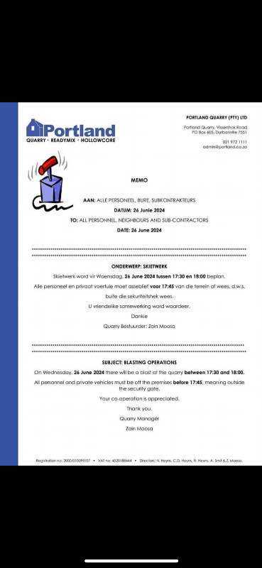
Memo (public domain)
West Beach Bloubergstrand (3.8 km W of epicenter) [Map] / Weak shaking (MMI III) / rattling, vibrating / 1-2 s : Very weak like you feel sound or thunder. It was quite loud though, we thought it was thunder. | 2 users found this interesting.  
Sunningdale, Cape Town / Light shaking (MMI IV) / 2-5 s : Very loud bang that sounded like an explosion or something very heavy falling on the floor right next to us, along with the ground shaking.  
Table view CT / Weak shaking (MMI III) / vibration and rolling / 2-5 s : There was a loud dull thump followed by a vibration which I felt on the floor and the walls of my house rumbled. There was no shaking  
Richwood Cape Town 7441 / not felt : Heard a loud bang. Thought it was blasting at nearby quarries in the area. Previous seismic activity in recent years also resulted in similar bang. Did not feel tremor though.  
Parklanda (2.6 km W of epicenter) [Map] / Weak shaking (MMI III) / single lateral shake / 1-2 s : I was in my living room next to a large window. There was a loud bang and all the windows were shaking.  
Parklands north (3.5 km WNW of epicenter) [Map] / not felt : Loud bang | One user found this interesting.  
Bloubergstrand / Very weak shaking (MMI II) : Light rumble thought it was construction  
Parklands / Weak shaking (MMI III)
Mauritius / not felt
near Cape Town, Western Cape (3.9 km SSW of epicenter) [Map] / not felt (reported through our app)
Table View (3.2 km SW of epicenter) [Map] / not felt / single vertical bump / 1-2 s : Single bang as in an explosion. Slight rattle of glass panels.  
Table View / Weak shaking (MMI III) / rattling, vibrating / 2-5 s : Heard what sounded like a dump truck rumbling past then a loud bang and windows rattled.  
Parklands (1.1 km WSW of epicenter) [Map] / Very weak shaking (MMI II) / single vertical bump / very short : Heard a very loud bang and a shake  
Parklands , cape town (16.5 km S of epicenter) [Map] / Moderate shaking (MMI V) / single vertical bump / 1-2 s : Like a bomb going off. A thud , our windows rattled a bit  
Parklands north, cape town (2.9 km WNW of epicenter) [Map] / Weak shaking (MMI III) / rattling, vibrating / 2-5 s
Parklands (2.5 km WSW of epicenter) [Map] / Light shaking (MMI IV)
Parklands, Milnerton / Moderate shaking (MMI V) : Sudden explosion and all windows were rattling  
West Beach blouberg / Light shaking (MMI IV) / rattling, vibrating / very short
near Kraaifontein, City of Cape Town, Western Cape (2 km ENE of epicenter) [Map] / not felt
near Cape Town, Western Cape (1.3 km W of epicenter) [Map] / not felt / very short : Very loud bang. Sounded like an explosion.  
Flamingo Vlei, Table View / Light shaking (MMI IV) : Felt the shake through the floor tiles, light shake/movement  
near Cape Town, Western Cape (2.8 km SW of epicenter) [Map] / Weak shaking (MMI III) (reported through our app)
Parow / not felt
Durbanville / not felt : Nothing felt in Durbanville  
Sunningdale, cape town / Weak shaking (MMI III) / single lateral shake / very short
Sunningdale (3.6 km WNW of epicenter) [Map] / Light shaking (MMI IV) / rattling, vibrating / very short : Loud bang. Tiles cracked  
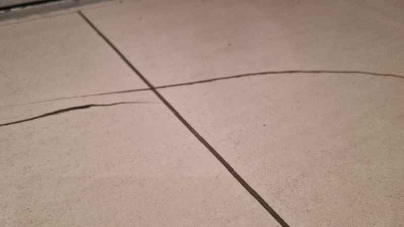
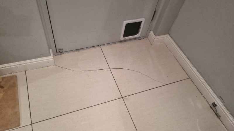
1000176924... .jpg (public domain)
1000176923... .jpg (public domain)
Show more
Show more

List of cities/places with most reports

PlaceDistance from epicenterAverage reported Shaking IntensityNr. of reports
Cape Town, Western Cape, South Africa
(Pop.: 3,433,441)
16.5 km (10 mi)
SW of epicenter
III: Weak shaking107
Kraaifontein, Western Cape, South Africa
(Pop.: 57,911)
18.5 km (12 mi)
E of epicenter
IV: Light shaking3
Retreat, Western Cape, South Africa
(Pop.: 25,745)
28 km (18 mi)
S of epicenter
III: Weak shaking3
Rosebank, Western Cape, South Africa
(Pop.: 10,000)
17.5 km (11 mi)
S of epicenter
IV: Light shaking1
Atlantida, Western Cape, South Africa
(Pop.: 67,491)
27 km (17 mi)
N of epicenter
II: Very weak shaking1
Note: Only reports with latitude/longitude coordinate positions given (162 in total) could be used for statistics.

What is Intensity and the Mercalli Intensity Scale?


The amount of shaking that occurs on the surface due to an earthquake is called the intensity. It is commonly measured on the so-called Modified Mercalli Intensity Scale (MMI) ranging from 1 (not felt) to 10 (extreme shaking), and given in Roman numerals as I,II,...IX, X, and often displayed with color codes ranging from light blue to dark red.
Earthquake intensity depends mainly on the magnitude and depth of the quake as well as the distance from the epicenter: The further away, the less shaking intensity occurs.
Read more about the MMI scale!

Number of reports by intensity

Shaking intensityNumber of reportsMin-Max distance from epicenter (*)Average distance (*)
I: Not felt461.3–113 km (0.8–70 mi)16 km (10 mi)
II: Very weak shaking451.1–28 km (0.7–17.1 mi)12.2 km (8 mi)
III: Weak shaking350–28 km (0–17.1 mi)8.8 km (5.4 mi)
IV: Light shaking250–16.2 km (0–10.1 mi)9.2 km (5.7 mi)
Notes
(*) Reports are filtered to exclude those that are likely highly inaccurate or esaggerated.
Only reports with latitude/longitude coordinate positions given (162 in total) could be used for geographic statistics.
I didn't feel it
I felt this quake
If you were near the epicenter and felt it, please share your experience and submit a short "I felt it" report! Other users would love to hear about it!
If you did NOT feel the quake although you were in the area, please report it as well! Your contribution is valuable to earthquake science and seismic hazard analysis.

Compare Quake Data

Data for the same earthquake as reported by different agencies

The more agencies report about the same quake and post similar data, the more confidence you can have in the data. It takes normally up to a few hours until earthquake parameters are calculated with near-optimum precision.
Mag Depth Time GMT
2024-06-26
Epicenter Agency
3.0 10 km
6.2 mi
(*)
15:52:48 Near Cape Town, Western Cape, South Africa VolcanoDiscovery (User-reported shaking)
Notes:
(*) A depth given as 10 km often means that the the depth of the quake could not determined with sufficient accuracy.

Seismograms

Seismic station: Sutherland, South Africa (SUR/II network) | Distance from quake: 265 km / 165 mi | Show on map | Station Info
Seismic station Sutherland, South Africa: vertical movement plot around time of quake (source: IRIS/BUD)
Seismogram (vertical component) around time of quake. Thin dotted red line indicates time of quake. Seismic waves arrive some time later, depending on distance. Bandpass filter applied: 0.5-10.0 Hz. Source: IRIS Buffer of Uniform Data (BUD) webtool
Show more

Previous quakes in the same area of this earthquake

The possible quake occurred 18 weeks after a magnitude 3.4 earthquake had hit on Wednesday, Feb 21, 2024, at 03:14 pm (GMT +1 local time) in 82 km (51 mi) distance to the west:
Mag. 3.4 earthquake South Africa - Feb 21, 2024 -
The largest quake near the epicenter of this quake during the 10 years before was an event of magnitude 3.7. It had occurred 9 years earlier, on Wednesday, Dec 2, 2015, at 09:14 am local time (Africa/Johannesburg GMT +2) in Western Cape,  South Africa: The strongest-ever (since 1900) recorded quake in this area measured magnitude 6.3. It had occurred 55 years ago earlier, on Monday, Sep 29, 1969, at 10:03 pm local time (Africa/Johannesburg GMT +2) in Western Cape,  South Africa: Below is a list and map of (larger or recent) earthquakes that had occurred in the area of this possible quake previously (within up to 100 km/61 mi distance, up to 300 km/183 mi for very large quakes above mag. 7). Filter the list to limit the number to show, by magnitude or time before.
Date and TimeMag
Depth
DistanceLocationDetailsMap
Feb 21, 03:14 pm (GMT +1)
3.4

10 km
82 km (51 mi) to the W South Africa 127 reportsInfo
Apr 25, 2022 06:57 am (GMT +1)
2.8

10 km
98 km (61 mi) to the SW South Africa Region
Info
Nov 4, 2021 06:28 am (Johannesburg)
2.7

10 km
25 km (16 mi) to the W South Africa Region
Info
Nov 17, 2020 12:27 am (Johannesburg)
3.5

5 km
72 km (45 mi) to the NW 76 km northwest of Cape Town, Western Cape, South Africa 3125 reportsInfo
Sep 27, 2020 09:12 am (Johannesburg)
2.7

10 km
25 km (15 mi) to the E Cape Winelands District Municipality, 8.6 km northeast of Kraaifontein, Western Cape, South Africa 119 reportsInfo
Sep 26, 2020 08:41 pm (Johannesburg)
2.9

10 km
20 km (12 mi) to the NE 15 km southeast of Atlantis, Western Cape, South Africa 111 reportsInfo
Dec 2, 2015 09:14 am (Johannesburg)
3.7

5 km
75 km (46 mi) to the NE 32 km northeast of Malmesbury, Western Cape, South Africa 1 report
Info
Mar 29, 2010 10:54 am (Johannesburg)
2.3

5 km
89 km (55 mi) to the E South Africa
Info
Sep 29, 1969 10:03 pm (Johannesburg)
6.3

15 km
100 km (62 mi) to the NE 13 km northeast of Ceres, Western Cape, South Africa Info

Map of earlier quakes in the area of this quake

[smaller] [bigger]

Map to embed or share

Why is there advertising on this site?
Sources: VolcanoDiscovery / VolcanoAdventures and other sources as noted.
Use of material: Most text and images on our websites are owned by us. Re-use is generally not permitted without authorization. Contact us for licensing rights.
Volcanoes & Earthquakes
VolcanoDiscovery Home
Volcanoes | Earthquakes | Photos | Volcano News | App
Adventure & Study Travel
Tours to Volcanoes and Volcanic Areas: walking tours, photo tours, study tours
Tours & Dates | FAQ | About us
Get our newsletter!
Company info
Contact | Legal info | Terms & conditions
Follow us
Follow us on facebook Follow us on Instagram Follow us on Twitter Visit our Youtube channel
EN | DE | EL | ES | FR | IT | RU
VolcanoDiscovery GmbH, Germany, Reg. nr.: HRB 103744, EU Tax Id: DE 297 465 123 owned and created by
Dr. Tom Pfeiffer, volcanologist, volcano photographer, tour organizer member of
IAVCEI
IAVCEI
Vulkanologische Gesellschaft
Volcanological Society
Ecotourism Greece
Ecotourism Greece
RUV insurance
Insured by R+V
VolcanoDiscovery © 2004- All Rights Reserved | Privacy - Cookie Settings
Cookie-free, privacy-friendly web stats