SEARCH
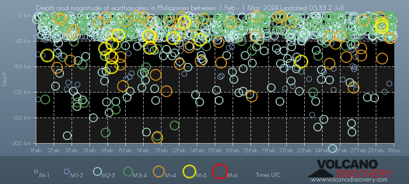
Date and Time | Mag Depth | Nearest Volcano | Location | Details | Map |
|---|---|---|---|---|---|
| Mar 1, 06:17 am (GMT +8) | 3.2 17 km | 58 km (36 mi) to the SE | Info | ||
| Mar 1, 04:41 am (GMT +8) | 3.6 2 km | 109 km (68 mi) to the NW | Info | ||
| Mar 1, 03:12 am (Makassar) | 3.6 10 km | 235 km (146 mi) to the SE | Info | ||
| Mar 1, 01:56 am (Manila) | 3.5 36 km | 8 km (5 mi) to the S | Info | ||
| Mar 1, 01:47 am (GMT +8) | 3.3 1 km | 51 km (32 mi) to the E | Info | ||
| Mar 1, 01:25 am (GMT +8) | 4.8 35 km | 54 km (34 mi) to the SE | Info | ||
| Mar 1, 01:18 am (GMT +8) | 4.6 35 km | 64 km (40 mi) to the SE | Info | ||
| Mar 1, 12:44 am (GMT +8) | 3.8 4 km | 71 km (44 mi) to the SE | Info | ||
| Feb 29, 10:27 pm (GMT +8) | 3.5 12 km | 71 km (44 mi) to the SE | Info | ||
| Feb 29, 10:11 pm (Manila) | 3.8 32 km | 16 km (9.9 mi) to the SE | Info | ||
| Feb 29, 10:08 pm (GMT +8) | 3.5 1 km | 72 km (45 mi) to the SE | Info | ||
| Feb 29, 05:49 pm (GMT +8) | 3.4 18 km | 65 km (40 mi) to the SE | Info | ||
| Feb 29, 10:05 am (GMT +8) | 3.1 18 km | 69 km (43 mi) to the SE | Info | ||
| Feb 29, 09:59 am (Manila) | 3.2 27 km | 19 km (12 mi) to the SE | Info | ||
| Feb 29, 09:53 am (GMT +8) | 3.1 2 km | 76 km (47 mi) to the SE | Info | ||
| Feb 29, 09:40 am (GMT +8) | 4.9 10 km | 74 km (46 mi) to the SE | Info | ||
| Feb 29, 09:05 am (Manila) | 4.8 67 km | 6 km (3.7 mi) to the SE | Info | ||
| Feb 29, 08:31 am (GMT +8) | 3.1 9 km | 73 km (45 mi) to the SE | Info | ||
| Feb 29, 08:23 am (GMT +8) | 5.4 18 km | 49 km (30 mi) to the SE | Info | ||
| Feb 29, 08:10 am (GMT +8) | 5.1 15 km | 54 km (34 mi) to the SE | Info | ||
| Wednesday, February 28, 2024 GMT (8 quakes) | |||||
| Feb 29, 03:58 am (GMT +8) | 4.1 2 km | 62 km (39 mi) to the SE | Info | ||
| Feb 29, 12:55 am (GMT +8) | 3.4 7 km | 76 km (47 mi) to the SE | Info | ||
| Feb 29, 12:28 am (Manila) | 3.2 8 km | Info | |||
| Feb 28, 07:31 pm (GMT +8) | 3.3 1 km | 39 km (24 mi) to the E | Info | ||
| Feb 28, 05:39 pm (GMT +8) | 3.3 1 km | 80 km (50 mi) to the SE | Info | ||
| Feb 28, 04:49 pm (Manila) | 3.3 26 km | 21 km (13 mi) to the SE | Info | ||
| Feb 28, 02:48 pm (GMT +8) | 3.6 20 km | 85 km (53 mi) to the SE | Info | ||
| Feb 28, 12:55 pm (GMT +8) | 3.4 18 km | 80 km (50 mi) to the SE | Info | ||
| Tuesday, February 27, 2024 GMT (11 quakes) | |||||
| Feb 28, 05:59 am (Manila) | 3.2 17 km | 8 km (5 mi) to the N | Info | ||
| Feb 28, 02:08 am (Manila) | 3.8 14 km | 11 km (6.8 mi) to the NE | Info | ||
| Feb 28, 12:58 am (GMT +8) | 3.9 12 km | 45 km (28 mi) to the SE | Info | ||
| Feb 27, 10:29 pm (GMT +8) | 3.4 16 km | 36 km (22 mi) to the SE | Info | ||
| Feb 27, 10:06 pm (GMT +8) | 3.5 6 km | 70 km (43 mi) to the SE | Info | ||
| Feb 27, 08:53 pm (Manila) | 4.2 7 km | Info | |||
| Feb 27, 04:22 pm (Manila) | 4.6 51 km | Info | |||
| Feb 27, 04:22 pm (Manila) | 3.7 19 km | 26 km (16 mi) to the SE | Info | ||
| Feb 27, 04:19 pm (GMT +8) | 3.4 21 km | 32 km (20 mi) to the SE | Info | ||
| Feb 27, 04:00 pm (GMT +8) | 4.4 63 km | 37 km (23 mi) to the SE | Info | ||
| Feb 27, 04:00 pm (GMT +8) | 3.5 15 km | 26 km (16 mi) to the SE | Info | ||
| Monday, February 26, 2024 GMT (9 quakes) | |||||
| Feb 27, 01:04 am (GMT +8) | 4.2 112 km | 102 km (63 mi) to the SE | Info | ||
| Feb 27, 01:04 am (GMT +8) | 3.4 132 km | 129 km (80 mi) to the SE | Info | ||
| Feb 26, 09:04 pm (Manila) | 3.1 9 km | 9 km (5.6 mi) to the SE | Info | ||
| Feb 26, 03:52 pm (GMT +8) | 3.7 20 km | 101 km (63 mi) to the SE | Info | ||
| Feb 26, 01:34 pm (Taipei) | 4.1 18 km | 222 km (138 mi) to the N | Info | ||
| Feb 26, 11:49 am (Manila) | 3.4 34 km | Info | |||
| Feb 26, 11:43 am (Manila) | 3.3 27 km | 19 km (12 mi) to the SE | Info | ||
| Feb 26, 11:40 am (Manila) | 4.9 65 km | 8 km (5 mi) to the SE | Info | ||
| Feb 26, 09:48 am (Manila) | 3.5 47 km | Info | |||
| Sunday, February 25, 2024 GMT (9 quakes) | |||||
| Feb 26, 07:42 am (Manila) | 3.1 25 km | 21 km (13 mi) to the SE | Info | ||
| Feb 26, 07:09 am (GMT +9) | 4.5 10 km | 189 km (117 mi) to the SE | Info | ||
| Feb 26, 01:18 am (Manila) | 3.7 1 km | Info | |||
| Feb 26, 12:38 am (Manila) | 4.1 33 km | 18 km (11 mi) to the W | Info | ||
| Feb 26, 12:23 am (GMT +8) | 3.5 25 km | 119 km (74 mi) to the SE | Info | ||
| Feb 25, 10:39 pm (Manila) | 3.6 1 km | 27 km (17 mi) to the NE | Info | ||
| Feb 25, 06:39 pm (Manila) | 3.3 14 km | 85 km (53 mi) to the SE | Info | ||
| Feb 25, 02:18 pm (GMT +8) | 3.5 2 km | 55 km (34 mi) to the SE | Info | ||
| Feb 25, 02:14 pm (Manila) | 4.6 44 km | Info | |||
| Saturday, February 24, 2024 GMT (12 quakes) | |||||
| Feb 25, 05:39 am (Manila) | 3.8 2 km | 44 km (27 mi) to the SE | Info | ||
| Feb 25, 04:14 am (GMT +8) | 3.1 3 km | 45 km (28 mi) to the SE | Info | ||
| Feb 25, 02:47 am (Manila) | 4.9 75 km | Info | |||
| Feb 25, 02:34 am (Manila) | 3.1 4 km | Info | |||
| Feb 25, 02:28 am (Manila) | 4.7 33 km | Info | |||
| Feb 25, 01:39 am (GMT +8) | 3.3 21 km | 19 km (12 mi) to the SE | Info | ||
| Feb 25, 12:19 am (Makassar) | 4.6 146 km | 151 km (94 mi) to the SE | Info | ||
| Feb 24, 11:59 pm (Manila) | 3.2 3 km | Info | |||
| Feb 24, 06:19 pm (GMT +8) | 3.8 11 km | 42 km (26 mi) to the SE | Info | ||
| Feb 24, 03:49 pm (Manila) | 3.4 19 km | 13 km (8.1 mi) to the SE | Info | ||
| Feb 24, 12:37 pm (Taipei) | 5.0 10 km | 271 km (168 mi) to the N | Info | ||
| Feb 24, 12:19 pm (Makassar) | 4.9 111 km | 168 km (104 mi) to the SE | Info | ||
| Friday, February 23, 2024 GMT (7 quakes) | |||||
| Feb 24, 12:15 am (Manila) | 3.7 13 km | 11 km (6.8 mi) to the SE | Info | ||
| Feb 23, 11:03 pm (Makassar) | 3.4 29 km | 215 km (134 mi) to the SE | Info | ||
| Feb 23, 07:50 pm (Manila) | 3.1 13 km | 12 km (7.5 mi) to the N | Info | ||
| Feb 23, 07:04 pm (Manila) | 3.4 120 km | Info | |||
| Feb 23, 05:44 pm (GMT +8) | 3.4 17 km | 82 km (51 mi) to the SE | Info | ||
| Feb 23, 12:32 pm (Makassar) | 3.6 10 km | 202 km (126 mi) to the SE | Info | ||
| Feb 23, 12:15 pm (Manila) | 3.6 15 km | 17 km (10.6 mi) to the SE | Info | ||
| Thursday, February 22, 2024 GMT (6 quakes) | |||||
| Feb 23, 05:01 am (Manila) | 4.8 383 km | 44 km (27 mi) to the SW | Info | ||
| Feb 23, 04:10 am (Manila) | 3.3 1 km | 2 km (1.2 mi) to the E | Info | ||
| Feb 22, 07:43 pm (Manila) | 5.0 72 km | 4 km (2.5 mi) to the SE | Info | ||
| Feb 22, 01:03 pm (GMT +8) | 3.9 15 km | Info | |||
| Feb 22, 11:48 am (Makassar) | 3.1 26 km | 195 km (121 mi) to the SE | Info | ||
| Feb 22, 08:43 am (GMT +8) | 3.2 5 km | Info | |||
| Wednesday, February 21, 2024 GMT (8 quakes) | |||||
| Feb 22, 04:39 am (GMT +8) | 3.1 9 km | 20 km (12 mi) to the N | Info | ||
| Feb 22, 12:11 am (Manila) | 3.1 30 km | 6 km (3.7 mi) to the SE | Info | ||
| Feb 21, 11:22 pm (GMT +8) | 4.3 10 km | 27 km (17 mi) to the SE | Info | ||
| Feb 21, 11:22 pm (Manila) | 3.8 1 km | 14 km (8.7 mi) to the N | Info | ||
| Feb 21, 10:59 pm (Manila) | 3.1 10 km | 5 km (3.1 mi) to the N | Info | ||
| Feb 21, 08:03 pm (GMT +8) | 3.2 63 km | 113 km (70 mi) to the SE | Info | ||
| Feb 21, 06:07 pm (GMT +8) | 3.1 24 km | 188 km (117 mi) to the SE | Info | ||
| Feb 21, 12:11 pm (Manila) | 3.3 23 km | 13 km (8.1 mi) to the SE | Info | ||
| Tuesday, February 20, 2024 GMT (9 quakes) | |||||
| Feb 21, 04:52 am (Manila) | 4.0 1 km | Info | |||
| Feb 21, 04:15 am (Manila) | 3.2 1 km | Info | |||
| Feb 21, 04:01 am (Manila) | 3.3 17 km | 17 km (10.6 mi) to the E | Info | ||
| Feb 21, 03:48 am (Manila) | 3.8 1 km | Info | |||
| Feb 21, 02:31 am (GMT +8) | 3.5 3 km | Info | |||
| Feb 21, 01:57 am (Manila) | 3.4 1 km | Info | |||
| Feb 21, 12:16 am (Manila) | 4.2 3 km | Info | |||
| Feb 20, 09:44 pm (GMT +8) | 3.4 13 km | 53 km (33 mi) to the SE | Info | ||
| Feb 20, 10:28 am (GMT +8) | 3.2 1 km | 75 km (47 mi) to the N | Info | ||
| Monday, February 19, 2024 GMT (7 quakes) | |||||
| Feb 20, 07:42 am (GMT +8) | 3.4 24 km | 19 km (12 mi) to the SE | Info | ||
| Feb 19, 11:18 pm (GMT +8) | 3.5 10 km | 29 km (18 mi) to the SE | Info | ||
| Feb 19, 07:07 pm (GMT +8) | 3.1 21 km | 85 km (53 mi) to the SE | Info | ||
| Feb 19, 06:26 pm (Manila) | 3.3 2 km | 101 km (63 mi) to the SE | Info | ||
| Feb 19, 04:59 pm (Manila) | 3.1 11 km | 2 km (1.2 mi) to the S | Info | ||
| Feb 19, 04:31 pm (Manila) | 3.4 1 km | 11 km (6.8 mi) to the N | Info | ||
| Feb 19, 10:33 am (GMT +8) | 3.2 241 km | 119 km (74 mi) to the SE | Info | ||
| Sunday, February 18, 2024 GMT (11 quakes) | |||||
| Feb 19, 06:56 am (GMT +8) | 3.5 18 km | 61 km (38 mi) to the SE | Info | ||
| Feb 19, 06:54 am (Manila) | 3.3 13 km | 20 km (12 mi) to the SE | Info | ||
| Feb 19, 06:25 am (GMT +8) | 3.4 14 km | 284 km (176 mi) to the SE | Info | ||
| Feb 19, 04:13 am (Manila) | 4.0 1 km | Info | |||
| Feb 19, 02:22 am (Manila) | 4.6 33 km | 28 km (17 mi) to the N | Info | ||
| Feb 18, 10:34 pm (GMT +8) | 3.2 11 km | 80 km (50 mi) to the SE | Info | ||
| Feb 18, 09:41 pm (GMT +8) | 3.3 18 km | 30 km (19 mi) to the SE | Info | ||
| Feb 18, 07:55 pm (GMT +8) | 3.5 12 km | 68 km (42 mi) to the SE | Info | ||
| Feb 18, 07:48 pm (Manila) | 4.5 127 km | Info | |||
| Feb 18, 07:10 pm (GMT +8) | 3.4 55 km | 36 km (22 mi) to the SE | Info | ||
| Feb 18, 10:02 am (GMT +8) | 3.1 7 km | 90 km (56 mi) to the SE | Info | ||
| Saturday, February 17, 2024 GMT (6 quakes) | |||||
| Feb 18, 04:25 am (GMT +8) | 3.1 78 km | 75 km (47 mi) to the SE | Info | ||
| Feb 18, 01:11 am (Manila) | 3.1 19 km | Info | |||
| Feb 17, 11:37 pm (GMT +8) | 3.1 40 km | 26 km (16 mi) to the SE | Info | ||
| Feb 17, 06:46 pm (GMT +8) | 3.7 306 km | 217 km (135 mi) to the S | Info | ||
| Feb 17, 04:24 pm (GMT +8) | 3.1 33 km | 109 km (68 mi) to the SE | Info | ||
| Feb 17, 02:18 pm (GMT +8) | 3.1 16 km | 52 km (32 mi) to the NW | Info | ||
| Friday, February 16, 2024 GMT (9 quakes) | |||||
| Feb 17, 06:28 am (GMT +8) | 3.3 8 km | 56 km (35 mi) to the SE | Info | ||
| Feb 17, 03:41 am (GMT +8) | 4.5 10 km | 81 km (50 mi) to the SE | Info | ||
| Feb 17, 03:06 am (GMT +8) | 3.3 9 km | 47 km (29 mi) to the SE | Info | ||
| Feb 17, 01:26 am (Manila) | 3.6 16 km | 17 km (10.6 mi) to the SE | Info | ||
| Feb 16, 09:50 pm (GMT +8) | 3.3 15 km | 34 km (21 mi) to the SE | Info | ||
| Feb 16, 06:05 pm (GMT +8) | 3.5 4 km | 40 km (25 mi) to the S | Info | ||
| Feb 16, 04:01 pm (Manila) | 3.7 22 km | 29 km (18 mi) to the SE | Info | ||
| Feb 16, 02:05 pm (Makassar) | 4.6 152 km | 244 km (152 mi) to the S | Info | ||
| Feb 16, 08:26 am (Manila) | 3.2 7 km | Info | |||
| Thursday, February 15, 2024 GMT (10 quakes) | |||||
| Feb 16, 07:58 am (Manila) | 4.5 74 km | 7 km (4.3 mi) to the SE | Info | ||
| Feb 16, 07:16 am (GMT +8) | 3.1 20 km | 21 km (13 mi) to the SE | Info | ||
| Feb 16, 06:01 am (Manila) | 3.2 1 km | 8 km (5 mi) to the N | Info | ||
| Feb 16, 05:55 am (Manila) | 3.8 1 km | 20 km (12 mi) to the N | Info | ||
| Feb 16, 03:47 am (Manila) | 3.4 1 km | Info | |||
| Feb 16, 03:34 am (GMT +8) | 3.3 26 km | 44 km (27 mi) to the S | Info | ||
| Feb 16, 02:53 am (Manila) | 4.6 42 km | 1 km (0.6 mi) to the SE | Info | ||
| Feb 16, 12:00 am (GMT +8) | 3.1 8 km | 68 km (42 mi) to the SE | Info | ||
| Feb 15, 08:02 pm (Manila) | 3.3 26 km | 31 km (19 mi) to the N | Info | ||
| Feb 15, 09:19 am (Manila) | 3.4 1 km | Info | |||
| Wednesday, February 14, 2024 GMT (7 quakes) | |||||
| Feb 15, 04:14 am (Makassar) | 3.9 10 km | 213 km (132 mi) to the SE | Info | ||
| Feb 15, 02:42 am (Manila) | 3.8 48 km | 2 km (1.2 mi) to the SE | Info | ||
| Feb 15, 12:59 am (Manila) | 3.2 5 km | Info | |||
| Feb 14, 10:37 pm (GMT +8) | 3.1 10 km | 53 km (33 mi) to the N | Info | ||
| Feb 14, 09:20 pm (Manila) | 4.5 5 km | 5 km (3.1 mi) to the NW | Info | ||
| Feb 14, 03:59 pm (GMT +8) | 4.8 71 km | 27 km (17 mi) to the SE | Info | ||
| Feb 14, 03:21 pm (Manila) | 5.0 37 km | 4 km (2.5 mi) to the E | Info | ||
| Tuesday, February 13, 2024 GMT (10 quakes) | |||||
| Feb 14, 04:58 am (GMT +8) | 3.6 12 km | 81 km (50 mi) to the SE | Info | ||
| Feb 14, 04:50 am (GMT +8) | 3.1 8 km | 56 km (35 mi) to the N | Info | ||
| Feb 14, 04:09 am (GMT +8) | 3.1 14 km | 14 km (8.7 mi) to the E | Info | ||
| Feb 14, 01:43 am (Manila) | 4.8 17 km | 11 km (6.8 mi) to the SE | Info | ||
| Feb 13, 09:51 pm (GMT +8) | 3.3 122 km | 126 km (78 mi) to the SE | Info | ||
| Feb 13, 06:40 pm (GMT +8) | 3.5 28 km | 22 km (14 mi) to the SE | Info | ||
| Feb 13, 05:00 pm (GMT +8) | 4.7 50 km | 31 km (19 mi) to the SE | Info | ||
| Feb 13, 03:31 pm (GMT +8) | 4.5 50 km | 188 km (117 mi) to the SE | Info | ||
| Feb 13, 02:24 pm (Makassar) | 3.1 133 km | 210 km (130 mi) to the SE | Info | ||
| Feb 13, 08:34 am (GMT +8) | 5.0 10.3 km | 30 km (19 mi) to the SE | Info | ||
| Monday, February 12, 2024 GMT (10 quakes) | |||||
| Feb 13, 07:58 am (Taipei) | 4.0 6.7 km | 293 km (182 mi) to the N | Info | ||
| Feb 13, 03:20 am (Manila) | 3.2 2 km | 14 km (8.7 mi) to the N | Info | ||
| Feb 13, 03:12 am (Manila) | 4.1 2 km | 2 km (1.2 mi) to the NW | Info | ||
| Feb 12, 11:31 pm (Manila) | 4.7 28 km | 17 km (10.6 mi) to the SE | Info | ||
| Feb 12, 11:04 pm (Manila) | 4.4 76 km | 18 km (11 mi) to the SE | Info | ||
| Feb 12, 09:28 pm (Manila) | 3.1 30 km | Info | |||
| Feb 12, 07:55 pm (GMT +8) | 4.8 13 km | 128 km (80 mi) to the N | Info | ||
| Feb 12, 06:00 pm (GMT +8) | 3.1 19 km | 37 km (23 mi) to the N | Info | ||
| Feb 12, 01:32 pm (Manila) | 3.2 172 km | 9 km (5.6 mi) to the SE | Info | ||
| Feb 12, 10:03 am (GMT +8) | 5.3 35 km | 57 km (35 mi) to the SE | Info | ||
| Sunday, February 11, 2024 GMT (6 quakes) | |||||
| Feb 12, 05:30 am (GMT +8) | 4.7 10 km | 64 km (40 mi) to the E | Info | ||
| Feb 12, 03:11 am (GMT +8) | 3.3 1 km | 45 km (28 mi) to the SE | Info | ||
| Feb 12, 02:23 am (GMT +8) | 3.4 4 km | 77 km (48 mi) to the SE | Info | ||
| Feb 11, 09:16 pm (GMT +8) | 4.6 119 km | 101 km (63 mi) to the SE | Info | ||
| Feb 11, 04:00 pm (Manila) | 3.3 10 km | 11 km (6.8 mi) to the SE | Info | ||
| Feb 11, 11:31 am (GMT +8) | 3.3 4 km | 74 km (46 mi) to the SE | Info | ||
| Saturday, February 10, 2024 GMT (13 quakes) | |||||
| Feb 11, 04:04 am (GMT +8) | 3.1 52 km | 97 km (60 mi) to the SE | Info | ||
| Feb 11, 03:58 am (GMT +8) | 4.4 192 km | 92 km (57 mi) to the SE | Info | ||
| Feb 11, 03:58 am (GMT +8) | 3.5 188 km | 58 km (36 mi) to the SE | Info | ||
| Feb 11, 01:03 am (Manila) | 4.6 93 km | 21 km (13 mi) to the SE | Info | ||
| Feb 10, 11:39 pm (GMT +8) | 3.6 150 km | 129 km (80 mi) to the SE | Info | ||
| Feb 10, 05:21 pm (Manila) | 4.6 34 km | 26 km (16 mi) to the E | Info | ||
| Feb 10, 04:07 pm (Manila) | 4.6 37 km | 20 km (12 mi) to the N | Info | ||
| Feb 10, 02:20 pm (GMT +8) | 3.7 19 km | 17 km (10.6 mi) to the SE | Info | ||
| Feb 10, 01:21 pm (Manila) | 5.4 50 km | Info | |||
| Feb 10, 12:22 pm (Makassar) | 3.3 33 km | 236 km (147 mi) to the SE | Info | ||
| Feb 10, 11:36 am (GMT +8) | 4.4 10 km | 118 km (73 mi) to the N | Info | ||
| Feb 10, 11:28 am (Manila) | 3.3 30 km | 16 km (9.9 mi) to the SE | Info | ||
| Feb 10, 11:22 am (Manila) | 5.8 32 km | Info | |||
| Friday, February 9, 2024 GMT (11 quakes) | |||||
| Feb 10, 02:35 am (GMT +8) | 3.2 13 km | 27 km (17 mi) to the SE | Info | ||
| Feb 10, 12:48 am (GMT +8) | 3.6 1 km | 97 km (60 mi) to the SE | Info | ||
| Feb 10, 12:19 am (GMT +8) | 4.0 2 km | 69 km (43 mi) to the SE | Info | ||
| Feb 9, 09:58 pm (Manila) | 3.5 6 km | Info | |||
| Feb 9, 09:49 pm (GMT +8) | 3.1 90 km | 72 km (45 mi) to the SE | Info | ||
| Feb 9, 07:04 pm (GMT +8) | 3.2 12 km | 31 km (19 mi) to the SE | Info | ||
| Feb 9, 06:41 pm (Manila) | 3.5 10 km | 10 km (6.2 mi) to the SE | Info | ||
| Feb 9, 04:54 pm (GMT +8) | 3.4 543 km | 49 km (30 mi) to the S | Info | ||
| Feb 9, 04:24 pm (GMT +8) | 3.5 5 km | 27 km (17 mi) to the SE | Info | ||
| Feb 9, 12:19 pm (GMT +8) | 4.0 1 km | 83 km (52 mi) to the SE | Info | ||
| Feb 9, 09:27 am (Manila) | 3.1 1 km | Info | |||
| Thursday, February 8, 2024 GMT (9 quakes) | |||||
| Feb 9, 06:36 am (Manila) | 3.1 33 km | 12 km (7.5 mi) to the SE | Info | ||
| Feb 9, 01:02 am (GMT +8) | 3.6 11 km | 128 km (80 mi) to the SE | Info | ||
| Feb 9, 12:49 am (GMT +8) | 3.3 305 km | 125 km (78 mi) to the S | Info | ||
| Feb 8, 08:40 pm (GMT +8) | 3.2 1 km | 103 km (64 mi) to the SE | Info | ||
| Feb 8, 08:09 pm (GMT +8) | 3.2 22 km | 53 km (33 mi) to the SE | Info | ||
| Feb 8, 05:30 pm (Manila) | 3.4 18 km | 16 km (9.9 mi) to the N | Info | ||
| Feb 8, 04:38 pm (Manila) | 3.2 12 km | 12 km (7.5 mi) to the NW | Info | ||
| Feb 8, 02:28 pm (GMT +8) | 4.0 9 km | 63 km (39 mi) to the SE | Info | ||
| Feb 8, 09:26 am (GMT +8) | 4.4 111 km | 52 km (32 mi) to the SE | Info | ||
| Wednesday, February 7, 2024 GMT (16 quakes) | |||||
| Feb 8, 05:50 am (GMT +8) | 4.0 10 km | 296 km (184 mi) to the SE | Info | ||
| Feb 8, 04:09 am (Manila) | 4.7 64 km | 26 km (16 mi) to the SE | Info | ||
| Feb 8, 04:09 am (GMT +8) | 3.9 7 km | 42 km (26 mi) to the SE | Info | ||
| Feb 8, 03:49 am (Manila) | 4.6 77 km | 22 km (14 mi) to the SE | Info | ||
| Feb 8, 01:49 am (GMT +8) | 3.1 22 km | 83 km (52 mi) to the SE | Info | ||
| Feb 8, 01:20 am (GMT +8) | 3.3 1 km | 63 km (39 mi) to the SE | Info | ||
| Feb 8, 12:05 am (Manila) | 5.4 31 km | 17 km (10.6 mi) to the N | Info | ||
| Feb 7, 07:45 pm (Manila) | 3.5 24 km | 13 km (8.1 mi) to the NW | Info | ||
| Feb 7, 07:18 pm (GMT +8) | 3.3 147 km | 30 km (19 mi) to the SE | Info | ||
| Feb 7, 01:46 pm (GMT +8) | 4.7 30 km | 102 km (63 mi) to the SE | Info | ||
| Feb 7, 12:05 pm (Manila) | 5.4 44 km | Info | |||
| Feb 7, 11:31 am (Manila) | 3.7 11 km | Info | |||
| Feb 7, 10:57 am (GMT +8) | 5.0 81 km | 49 km (30 mi) to the SE | Info | ||
| Feb 7, 10:52 am (GMT +8) | 3.1 1 km | 66 km (41 mi) to the SE | Info | ||
| Feb 7, 10:44 am (GMT +8) | 5.0 66 km | 44 km (27 mi) to the SE | Info | ||
| Feb 7, 08:09 am (GMT +8) | 4.5 60 km | 51 km (32 mi) to the SE | Info | ||
| Tuesday, February 6, 2024 GMT (12 quakes) | |||||
| Feb 7, 04:16 am (Manila) | 3.2 29 km | 7 km (4.3 mi) to the SE | Info | ||
| Feb 7, 01:36 am (Manila) | 3.6 2 km | Info | |||
| Feb 7, 12:20 am (Manila) | 4.7 2 km | Info | |||
| Feb 6, 11:36 pm (GMT +8) | 3.1 75 km | 124 km (77 mi) to the SE | Info | ||
| Feb 6, 11:09 pm (Makassar) | 3.6 183 km | 44 km (27 mi) to the SE | Info | ||
| Feb 6, 10:37 pm (Manila) | 5.1 52 km | Info | |||
| Feb 6, 09:47 pm (GMT +8) | 3.1 63 km | 56 km (35 mi) to the SE | Info | ||
| Feb 6, 09:17 pm (GMT +8) | 3.7 63 km | 61 km (38 mi) to the SE | Info | ||
| Feb 6, 07:56 pm (Makassar) | 3.4 162 km | 292 km (181 mi) to the S | Info | ||
| Feb 6, 05:16 pm (Manila) | 3.3 11 km | Info | |||
| Feb 6, 03:00 pm (Makassar) | 3.8 18 km | 229 km (142 mi) to the SE | Info | ||
| Feb 6, 12:20 pm (Manila) | 4.6 10 km | Info | |||
| Monday, February 5, 2024 GMT (5 quakes) | |||||
| Feb 6, 07:15 am (Manila) | 3.2 12 km | Info | |||
| Feb 6, 04:04 am (GMT +8) | 4.3 42 km | 283 km (176 mi) to the SE | Info | ||
| Feb 6, 12:29 am (GMT +8) | 3.1 1 km | 87 km (54 mi) to the N | Info | ||
| Feb 5, 02:39 pm (GMT +8) | 3.2 13 km | 31 km (19 mi) to the SE | Info | ||
| Feb 5, 11:43 am (GMT +8) | 3.5 1 km | 78 km (48 mi) to the SE | Info | ||
| Sunday, February 4, 2024 GMT (12 quakes) | |||||
| Feb 5, 03:21 am (Manila) | 3.4 17 km | Info | |||
| Feb 5, 02:35 am (GMT +8) | 3.4 23 km | 77 km (48 mi) to the SE | Info | ||
| Feb 5, 02:11 am (Manila) | 3.8 77 km | Info | |||
| Feb 5, 01:41 am (GMT +8) | 3.1 9 km | 61 km (38 mi) to the N | Info | ||
| Feb 5, 02:02 am (GMT +9) | 3.3 18 km | 129 km (80 mi) to the SE | Info | ||
| Feb 5, 12:14 am (GMT +8) | 3.1 1 km | 78 km (48 mi) to the SE | Info | ||
| Feb 4, 11:58 pm (GMT +8) | 3.1 21 km | 91 km (57 mi) to the SE | Info | ||
| Feb 4, 11:39 pm (GMT +8) | 3.1 1 km | 95 km (59 mi) to the SE | Info | ||
| Feb 4, 10:22 pm (Manila) | 3.4 12 km | Info | |||
| Feb 4, 04:42 pm (GMT +8) | 3.1 136 km | 56 km (35 mi) to the SE | Info | ||
| Feb 4, 09:33 am (GMT +8) | 3.4 41 km | 27 km (17 mi) to the SE | Info | ||
| Feb 4, 09:19 am (Manila) | 4.3 22 km | Info | |||
| Saturday, February 3, 2024 GMT (11 quakes) | |||||
| Feb 4, 06:37 am (Manila) | 4.1 28 km | 11 km (6.8 mi) to the SE | Info | ||
| Feb 4, 02:43 am (Manila) | 4.5 70 km | Info | |||
| Feb 4, 02:38 am (GMT +8) | 3.6 11 km | 66 km (41 mi) to the SE | Info | ||
| Feb 3, 07:38 pm (GMT +8) | 3.2 20 km | 58 km (36 mi) to the SE | Info | ||
| Feb 3, 04:32 pm (GMT +8) | 3.2 3 km | 55 km (34 mi) to the SE | Info | ||
| Feb 3, 02:53 pm (GMT +8) | 3.1 16 km | 24 km (15 mi) to the SE | Info | ||
| Feb 3, 02:01 pm (GMT +8) | 3.7 19 km | 43 km (27 mi) to the SE | Info | ||
| Feb 3, 05:28 am (GMT +0) | 3.6 1 km | 83 km (52 mi) to the SE | Info | ||
| Feb 3, 01:05 pm (GMT +8) | 3.6 12 km | 46 km (29 mi) to the SE | Info | ||
| Feb 3, 11:51 am (Manila) | 3.8 65 km | Info | |||
| Feb 3, 08:59 am (GMT +8) | 4.1 6 km | 66 km (41 mi) to the SE | Info | ||
| Friday, February 2, 2024 GMT (12 quakes) | |||||
| Feb 3, 06:40 am (GMT +8) | 3.3 1 km | 69 km (43 mi) to the SE | Info | ||
| Feb 3, 05:32 am (GMT +8) | 3.4 6 km | 66 km (41 mi) to the SE | Info | ||
| Feb 3, 05:14 am (GMT +8) | 3.5 1 km | 63 km (39 mi) to the SE | Info | ||
| Feb 3, 04:49 am (GMT +8) | 3.7 2 km | 74 km (46 mi) to the SE | Info | ||
| Feb 3, 04:19 am (GMT +8) | 4.0 4 km | 53 km (33 mi) to the SE | Info | ||
| Feb 3, 04:12 am (GMT +8) | 3.5 1 km | 82 km (51 mi) to the SE | Info | ||
| Feb 3, 01:12 am (GMT +8) | 3.5 47 km | 263 km (163 mi) to the SE | Info | ||
| Feb 3, 01:01 am (Manila) | 3.7 17 km | Info | |||
| Feb 3, 12:38 am (Manila) | 4.8 82 km | 2 km (1.2 mi) to the SE | Info | ||
| Feb 2, 10:25 pm (Manila) | 3.1 32 km | 7 km (4.3 mi) to the SE | Info | ||
| Feb 2, 07:59 pm (Manila) | 3.3 6 km | Info | |||
| Feb 2, 03:12 pm (GMT +8) | 3.4 12 km | 56 km (35 mi) to the SE | Info | ||
| Thursday, February 1, 2024 GMT (6 quakes) | |||||
| Feb 2, 07:30 am (GMT +8) | 3.4 8 km | 46 km (29 mi) to the S | Info | ||
| Feb 2, 05:35 am (GMT +8) | 5.1 63 km | 51 km (32 mi) to the SE | Info | ||
| Feb 2, 03:33 am (GMT +8) | 3.3 1 km | 53 km (33 mi) to the SE | Info | ||
| Feb 2, 02:46 am (GMT +8) | 3.2 3 km | 60 km (37 mi) to the SE | Info | ||
| Feb 1, 10:39 pm (GMT +8) | 3.3 8 km | 37 km (23 mi) to the SE | Info | ||
| Feb 1, 09:24 pm (GMT +8) | 4.0 119 km | 111 km (69 mi) to the SE | Info | ||
| or | ||
Look up quakes! | ||